
|
Cryptome DVDs are offered by Cryptome. Donate $25 for two DVDs of the Cryptome 12 and a half-years collection of 47,000 files from June 1996 to January 2009 (~6.9 GB). Click Paypal or mail check/MO made out to John Young, 251 West 89th Street, New York, NY 10024. The collection includes all files of cryptome.org, jya.com, cartome.org, eyeball-series.org and iraq-kill-maim.org, and 23,100 (updated) pages of counter-intelligence dossiers declassified by the US Army Information and Security Command, dating from 1945 to 1985.The DVDs will be sent anywhere worldwide without extra cost. | |||
May 1997
Source: Printed publication, 161 pp.
Prepared by
Maj Michael J. Muolo
Air University Air Command and Staff College
Compiled by
Maj Richard A. Hand
Edited by
Maj Richard A. Hand
Maj Bonnie Houchen
Maj Lou Larson
Air University Press
Maxwell Air Force Base, Alabama 36112-6428
December 1993
Disclaimer
This publication was produced in the Department of Defense school environment in the interest of academic freedom and the advancement of national defense-related concepts. The views expressed in this publication are those of the author and do not reflect the official policy or position of the Department of Defense or the United States government.
This publication has been reviewed by security and policy review authorities and is cleared for public release.
To the Reader
As with any published work, the material immediately dates itself, thus at times becoming less relevant. These two volumes have been written with the expressed intent of remaining valid for as many years as possible--with the hope of imparting an educational framework to build upon rather than current and specific facts that often change quickly. We hope the reader will learn principles and be stimulated in thought, rather than struggle with errata induced by rapid change.
Submit changes to:
Maj Michael J. Muolo
ACSC/DEAC 225
Chennault Circle
Maxwell AFB AL 36112-6426
"The space support for Desert Storm [and] Desert Shield will probably be the minimum support expected in any future crisis."
Vice Adm W. A. Dougherty, USN
Deputy Commander, US Space Command
15-21 April 1991
Space News
"The Gulf War 'was the first space war . . . it was the first war of the space age.' "
Gen Merrill A. McPeak
Air Force Chief of Staff
8 April 1991
Aviation Week & Space Technology
"Our technology superiority, particularly in space, was essential to our ability to prosecute the war quickly, safely and successfully."
Donald Atwood
Department of Defense Deputy Secretary
22 April 1991
Military Space
"This was the first war in which space played a central part, and DSP was a very important part of it."
Henry Cooper
Director of US Strategic Defense Initiative Organization
1-7 April 1991
Space News
"Space systems have become an integral part of all battle resources."
Lt Gen James S. Cassity, Jr., USAF
Director of Command, Control, and Communications for the Joint Chiefs of Staff
1-7 April 1991
Space News
"Imaging and SIGINT satellites played a very major role in the success of the air war and as a result, the success of the ground war, just in terms of providing a comprehensive target list, target base, for planning the air war, [and] allowing the assessment of damage."
Jeffrey T. Richelson
National Security Archive
Washington D.C.
4 March 1991
Aerospace Daily
Chapter
DISCLAIMERFOREWORD
PREFACE
ACKNOWLEDGMENTS
1 SPACE HISTORY: THE EVOLUTION OF SPACE POWER
Truman Years: 1945-1952Eisenhower Years: 1953-1960
International Geophysical Year
National Aeronautics and Space Administration
Missile Gap
Military Space SystemsCommunication and Navigation
Antiballistic Missiles
Antisatellites
X-20
Missile Warning and Space Surveillance
Program496L
North American Aerospace Defense Command and the Missile Warning NetworkKennedy and Johnson Years: 1961-1968
Military Space SystemsMilitary Satellites
Vela
Antisatellites
Antiballistic Missiles
Fractional Orbit Bombardment SystemMissile Warning and Space Surveillance Network
National Aeronautics and Space AdministrationNixon and Ford Years: 1969-1976
Soviet Threat
Antiballistic Missiles
Military Space SystemsAntisatellites
Missile Warning and Space Surveillance NetworkNational Aeronautics and Space Administration
Apollo X
Apollo/Soyuz Test ProgramCarter Years: 1977-1980
Military Space SystemsAntisatellite Weapons
Satellite Survivability
Directed Energy Weapons
Missile Warning and the Space Surveillance NetworkNational Aeronautics and Space Administration
Reagan Years: 1981-1988
Arms NegotiationsStrategic Defense Initiative and the Antiballistic Missile TreatyMilitary Space Systems
Antisatellites
Missile Warning and Spacetrack NetworkNational Aeronautics and Space Administration Shuttle Program
Bush Years: 1989-1992
Notes
2 SPACE LAW, POLICY, AND DOCTRINE
International Space LawDomestic Space Law
National Space Policy
Early Policy
Intervening Years
Carter Administration Space Policy
Reagan Administration Space Policy
Bush Administration Space Policy
Department of Defense Space Policy
Air Force Space PolicySpace Doctrine
Joint Space Doctrine
Air Force Space DoctrineNotes
3 SPACE SUPPORT TO THE WAR FIGHTERS: SPACE MISSIONS AND MILITARY SPACE SYSTEMS
Force Support--Air Force Satellite Control NetworkDedicated and Common-User Elements
Types of Satellite Support
Satellite Operations Centers
Space Vehicle Support--Pass/Contact Description
Remote Tracking StationsRemote Tracking Station Communications
Remote Tracking Station--Mission Unique InterfacesCommand Centers
Network Control System
Communications System--Major Components
Additional SystemsForce Enhancement
Spacelift
Surveillance and ReconnaissanceDefense Support Program
LandsatNavigation Systems
Communications SystemsDefense Satellite Communications System
NATO III
Fleet Satellite Communications SystemMeteorology
Aerospace Control
Space Surveillance
Space Surveillance NetworkDedicated Sensors
Collateral Sensors
Contributing SensorsProtection
NegationForce Applications
Global Protection against Limited StrikesAccidental and Unauthorized Strikes
Elements of Global Protection against Limited StrikesGlobal Protection against Limited Strikes Architecture
Brilliant Pebbles
US Ground-Based DefenseFollow-on Systems
Notes
The Launch CentersVandenberg Air Force Base
Cape Canaveral Air Force StationCurrent Launch Vehicles
SCOUT
Pegasus
Delta
Atlas
Titan
Space Transportation SystemThe Launch Process
Notes
5 MILITARY SPACE STRATEGY AND EVOLVING SYSTEMS
Space Force SupportSpace Force Enhancement
Evolving Systems
Space-Based Wide Area Surveillance
Multispectral Imagery
Milstar
Ultra High Frequency Follow-On
Tactical Satellites
National Launch System
National Aerospace Plane
Single Stage to Orbit
Global Protection against Limited StrikesNotes
Classified Annexes (under separate cover)
[Not here]
Annex
A Space Support to Desert Storm (U)B Passive Surveillance System (U)
C Defense Support Program and Follow-on Early Warning System (U)
Illustrations
Figure
1 Satellite Support Functional Flow
2 Remote Tracking Station Locations
3 Current Third Country Ballistic Missile Capability
4 GPALS Integrated System and Key Elements
5 GPALS Architecture: Space-Based Protection against
Ballistic Missiles with a Range Greater than 600 Kilometers
6 GPALS Architecture: Ground-Based Protection against Strategic Ballistic Missiles
7 GPALS Architecture: Protection against SLBMs
8 Complete GPALS Architecture
9 Launch Base Processing Flow
10 Typical Delta II Mission Profile
11 National Launch System Vehicle Specifications
12 Single Stage to Orbit
Table
1 International Agreements that Limit Military Activities in Space
2 Launch Capability in California
3 Launch Capability in Florida
Photograph [Not with text; separate hyperlinked files]
Echo Balloon
Mercury Capsule (Artist's Conception)
Mercury Capsule Dimensions
MR-3 Lift-off
Mercury-Atlas 9
Gemini IX Lift-off
GT-3 Lift-off
Saturn S-IVB Engine
Apollo 15 Rollout
Skylab
Apollo/Soyuz Test Project Spacecraft
Voyager Spacecraft
Landsat C
Landsat D
Global Positioning System Satellite
Defense Satellite Communications System III Satellite
Fleet Satellite Communications System Satellite
Defense Meteorological Satellite Program Satellite
PAVE PAWS
Pegasus
Delta II
Atlas
Atlas-Centaur
Titan II
Titan IV
Space Transportation System
Space-Based Wide Area Surveillance Satellite
National Aerospace Plane
Foreword
For over 30 years, space has been integral to the security of the United States and its allies. Secretary of the Air Force Donald B. Rice said, "Space forces are a central element of our global reach, the principal attribute of the Air Force' s aerospace operations of the future."
Recent conflicts have underscored the role space now plays in our combat capability. Our navigation satellites provide instant pinpoint positioning and targeting information to aircraft, ground forces, ships, and command centers. Communications satellites provide global connectivity between all levels of our national security infrastructure. Weather satellites report meteorological data in near real time directly to forces in the theater. Early warning satellites, which detect and report ballistic missile launches, serve strategic objectives as well as tactical purposes. These and other space systems will continue to be essential to the success of future military operations. Whenever and wherever American men and women fight, space will forevermore be critical to their success.
Air Force policy states, "Spacepower will assume as decisive a role in future combat operations as airpower has today." As we move toward this goal, educating our future leadership becomes even more critical. Air Force Space Command has collaborated with Air University to produce this new edition of the Space Handbook. It is an excellent two volume instructional and reference manual. Volume 1 discusses space system organizations, roles and missions, policy, and space applications. Volume 2 provides an introduction to the physical laws and principles of space.
This handbook will provide new students of space a sound basis from which to grow and will stimulate experienced professionals. It is your guide to space and your invitation to all the excitement and opportunity therein.
[Signature]JAY W. KELLEY
Lieutenant General, USAF
Commander, Air University
One of the primary efforts of all space advocates is to integrate, fully and effectively, the tremendous force enhancement capabilities of space-related assets into our national war-fighting capabilities. Lt Gen Thomas S. Moorman, Jr., states that Air Force Space Command's focus should relate to learning what the war-fighting commands need in the way of space systems. Part and parcel of this job is to demystify space and develop new applications for our space products.
Recent military operations have shown that the immense tactical application possibilities of current space systems are underused. The reason is that the war fighters are not familiar with space assets or capabilities and therefore do not have the tools or training to use them. The primary focus of this volume is to educate and begin to convince war fighters that space systems can do so much more for them than simply let them watch the fight. If the vast potential of space systems is fully understood and effectively applied, space can have a tremendous impact on mission planning and execution, saving friendly lives and increasing weapon effectiveness.
Support from space assets has been successful in several recent operations. For example: Desert One (Iran), Urgent Fury (Grenada), El Dorado Canyon (Libya), and Just Cause (Panama). Prior to the massive effort to integrate space into the Desert Storm theater, most efforts using space had limited success and focused mostly on communications and intelligence. Primarily, this focus was due to a lack of knowledge and understanding of space systems capabilities within the war-fighting community. Most requests were ad hoc reactions and piecemeal efforts, not fully coordinated between users and providers of space systems.
Classified Annex A to this handbook covers in-depth space support to Operation Desert Storm. Even though Desert Storm was tremendously successful, it showed the need for better space understanding and applications. Gen Norman Schwarzkopf echoed this idea when he briefed Congress on problems with battle damage assessment and intelligence dissemination. Better space applications can greatly improve these areas as well as other missions.
We have not fully exploited the expansive potential of space systems. We have extremely sophisticated and capable space systems that have the advantages of high volume collection and relay of global data in real time or near real time. These advantages allow our forces to see, measure, and proactively respond to a threat. However, among other problems, the users have prototype equipment operated by untrained personnel which results in a trickle of noncurrent information to the unit and aircrew level. Also, there is the continuing problem of overclassifying the output and products of some space systems. Space asset owners and operators must capitalize on the enormous amount of money already spent on space systems and maximize their capabilities in supporting combat execution.
Desert Storm featured a great improvement in space system utility, giving us a new baseline from which to grow. According to Lt Gen Thomas S. Moorman, Jr., "We proved our worth in the Persian Gulf, and in the future we will prove our worth as we continue to enhance combat effectiveness with space systems." Space provided critical support to all the services in navigation, communications, weather, and intelligence. In an encouraging article from Air Force Magazine, James Canan writes, "In military circles, space is losing its high-flown, R&D aura and is taking on a down-to-earth, operational look. Warfighting commanders are fast becoming sold on space systems." The information that space systems provide to tactical forces is extremely well received and changes the way we plan a lot of missions. We are making a difference! This difference is an example of what needs to happen, but we must also improve our education process.
According to Lt Gen Thomas S. Moorman, "Our goal [as space advocates] is to create a climate where the flying commands are comfortable with space, and think of space solutions to their operational problems." The space community needs to sell the utility and value of space to the war fighters and thereby increase their comfort index on space. Lt Col Randy Peixotto, Air Force Special Operations Command (AFSOC) states, "AFSOC forces use space capabilities on a daily basis and on every operational mission, but like most organizations, we do not normally recognize the extent to which we are dependent on satellites." War-fighting commands have to become familiar with what is available and practice using it. We need to ensure they have continuous hands-on access to hardware even during peacetime. The phrase "train as we fight" applies here and lies at the heart of the Space Handbook. This text is a training tool or a stepping stone for the uninitiated and is for use by neophytes who need to be aware of the capabilities and potential of space. We must educate our leaders and war fighters on space, and the Handbook is a means to help.
The bottom line is that Air Force Space Command and the Space Handbook focus on space as a force enhancer to war-fighting operations. The objective is to provide better understanding which will capitalize on the billions of dollars invested in space systems to allow us to execute combat operations more effectively.
As with most work, many people are responsible for this project's success. There are many to thank--some for considerable help and a few for their superlative efforts--without whom I could not have completed this project! There are so many to acknowledge that I can list only their names. I hope they will forgive this brevity. They know what they have accomplished, how helpful they have been, and that I am truly grateful !
The following individuals made most meaningful contributions in many areas, including helping to: organize, provide information, consult, support, coordinate, edit, advise, approve, assist, empathize, suggest, and more.
   Col Jack Harris        Col Sandy Mangold       Col Rod Payne
   Dr "Buck" Grinter      Ms Emily Adams          Capt Robert Freeman
   Maj Ted Burgner        Capt Jim Wolf           Mr John Jordan
   Maj Joe Squatrito      Maj Dale Madison        Maj Ron Del Gizzi
   TSgt Dennis Sanchez    Maj Jerry Rand          Maj Dwight Rauhala
   Lt Col Ken Henry       Maj Laurie Reh          Maj Jeff Walters
   Maj Robin Squatrito    Maj Daryl Tomczyk
There were three standouts in terms of support on this effort. These three individuals kept pushing me onward and upward towards what I hope and believe is a useful document. These individuals helped in such areas as typing, coordinating, editing, correcting, cheerleading, admonishing, encouraging, consulting, listening, and advocating. My deepest and sincerest thanks go to my wife Shirley Hand and to my friends and coworkers Andrea Pollitt and Bonnie Houchen! I am forever indebted to you.
To any whom I may have omitted, my apologies, but thank you nonetheless.
_____________________________________________________
The seeds of American rocket science sprouted haphazardly in a climate of apathy and ridicule. Due to a lack of interest in research and development before World War II, America's early rocket pioneers found few, if any, financial sponsors. Thus, European rocketeers took a substantial lead in rocket science.
Robert Goddard, the earliest and arguably the greatest American scientist in rocketry, was born in 1882. Inspired by the writings of H. G. Wells, Goddard began experimenting with solid-propellant rockets during World War I and, with the help of the Smithsonian Institution,l published his first thesis on rocket propulsion, "A Method of Obtaining Extreme Altitudes" in 1919.2 He began experimenting with liquid rocket engines in 1923.
Goddard conducted more than 100 static tests, 48 live flight tests, and developed the first functional gyroscopic attitude control system for rockets. Other firsts included the first liquid propellant rocket in 1926 and pressure and pump feed systems. These were tremendous accomplishments by amateur standards, which is the way he should be rated when compared to the highly organized German efforts of the same period. His one-man-show methods were totally outdated by 1940, and his secrecy left his later and most important writings unpublished.3
Goddard was not the only American interested in rockets. The American Interplanetary Society (AIS), founded in 1930, sponsored liquid propellant rocket experiments on a farm in New Jersey. AIS changed its name to the American Rocket Society (ARS) in 1934.4 Of greater significance than ARS's rocket experiments was the founding of Reaction Motors, Incorporated (the first American private firm devoted to rocketry) by four ARS members.5
During World War II, the Allies became increasingly aware of the tremendous technological edge the Germans had in rocket development.6 The Allies began laying plans as early as 1942 to plunder German technology after the war, and a new type of military unit, the scientific intelligence unit, appeared in British and US services.7 The Soviets also demonstrated an interest in German technologies, and all these units worked to uncover as many Nazi secrets as possible because their respective governments were anxious to create their own rocket programs.8 In the United States too, there was high-level government interest in German rockets. The National Defense Research Committee became the Office of Scientific Research and Development, a very powerful organization with direct access to the president. Headed by Vannevar Bush, chairman of the National Advisory Committee on Aeronautics (NACA),9 this organization worked loosely with similar British organizations gathering scientific intelligence.10 Towards this end, the British and Americans on one hand and the Soviets on the other tried to keep as much of this information from each other as possible.11
Late in the war, the Germans used their rockets as vengeance weapons against the Allies. The German's greatest achievement, the A-4 or V-2--the first medium-range ballistic missile--had a length of 46.1 feet and a 56,000-pound-thrust engine powered by alcohol and liquid oxygen. Driven by its liquid propellant engine, the V-2 had a range of approximately 200 miles. Its warhead consisted of 2,000 pounds of amatol. For the most part, the V-2 and the earlier V-1 Buzzbomb had little immediate effect, but Hitler's weapons did exact a vengeance of sorts after the war by touching off a major international competition to secure the spoils of the Peenemunde rocket center.12
On 11 April 1945, US Army intelligence units reached the Mittelwerke, the secret underground V-2 factory in the Harz Mountains.13 (The Germans had moved production of the V-2 there after Allied bombing heavily damaged Peenemunde.14) As part of Operation Hermes (an American plan to secure rocket expertise), US personnel searched for German scientists to help with US rocket development and to get them out of the area before the Soviets arrived.15 (Both Peenemunde and the Mittelwerke were in the Soviet zone of occupation.) The Army immediately shipped enough parts to the US to assemble 100 V-2s for testing at White Sands Proving Grounds (now White Sands Missile Range [WSMR]) in New Mexico.16 Then on 2 May 1945, the Peenemunde rocket group (including Maj Gen Walter Dornberger, military chief of the rocket program, and Wernher von Braun, the chief scientist) surrendered to the US Seventh Army. By 30 September 1947, the US had recruited and contracted 457 German scientists and technicians who helped put the US in space faster than might otherwise have been possible.17
As World War II ground to a close, President Harry S Truman was faced with a decision that was to have far graver consequences for the postwar world than German V-2 development. This was the decision to use the atomic bomb in an effort to end the war against Japan quickly and at a lower cost in American lives than an invasion would require. The atomic bomb was to have a significant effect on the cold war between the Western Allies and the Soviet Union after World War II. The cold war manifested itself as a series of political, military, and propaganda confrontations characterized by limited wars, wars by proxy, the nuclear arms race, and the threat of nuclear war. In the end, the cold war encouraged competition, both friendly and unfriendly, and helped accelerate the pace of the coming space race.
In 1946, the US government began Project MX-774 to research and develop a 5,000-mile-range intercontinental ballistic missile (ICBM). Convair, the prime contractor, flew three experimental vehicles in 1948, largely at its own expense. These vehicles tested such advanced concepts as gimbal-mounted engines, separable nose cones, and stainless steel skin rolled so thin that it had to be inflated to keep its unsupported structure from collapsing (the balloon tank concept).18
Also in 1946, another US program, Project Bumper, began. This program gave the US much needed experience in the handling and design of large rockets and involved launching captured German V-2 rockets. Sixty-four V-2 rockets flew from White Sands, some as modified two-stage upper-atmospheric test vehicles employing the WAC-Corporal second stage. Two V-2s were launched from the Long Range Proving Ground (now the USAF Eastern Test Range on Cape Canaveral, Florida). The US Navy even launched a V-2 from an aircraft carrier, the USS Midway.19
The Hermes Project, the first major US ballistic missile program, was based at Fort Bliss, Texas. German scientists led by von Braun tested many rocket components and concepts. The Hermes Project laid the groundwork for what was to come. After Hermes ended in 1950, von Braun and his team moved to the Redstone Arsenal near Huntsville, Alabama, and worked for the Army Ballistic Missile Agency.20
Meanwhile, many top US military and scientific leaders, including Gen Henry H. ("Hap") Arnold, Vannevar Bush, Theodore von Karman, Hugh L. Dryden, and the Army Air Force Scientific Advisory Group, were skeptical of mating nuclear weapons with long-range missiles. In December 1945, Dr Bush told a congressional committee: "In my opinion, such a thing is impossible, I don't think anybody in the world knows how to do such a thing [put nuclear weapons on long-range missiles] and I feel confident it will not be done for a very long time to come.''21
As a result of such expert testimony, US ICBM research stopped in 1947. The argument was strong. No existing rocket could carry the atomic bomb of the day which weighed 10,000 pounds. Also at that time there was no way to guide such a weapon to a target halfway around the world.22 Experts said it would take at least 10 years to develop the systems necessary to make such a missile practical.23 The Air Force opted to design and test a number of cruise missile weapons that could carry the "bomb" better and farther with existing technology.24 Of these, only the Snark cruise missile reached the deployment stage in the late 1950s, and the Air Force deactivated it in 1961 after the Atlas ICBM came on line.25 In the meantime, development continued on shorter-ranged weapons, while the Atomic Energy Commission (AEC) tried to make nuclear weapons smaller.
In 1946, the RAND Corporation first proposed a military satellite system. A 2 May 1946 RAND study stated that a "satellite offers an observation aircraft which cannot be brought down by an enemy who has not mastered similar techniques," but mastering the techniques to build such a vehicle proved to be difficult.26 Electronics of the day were the roadblock as they were based on vacuum tubes. Electronic components were large, heavy, and needed lots of power. In 1948, a major breakthrough occurred when Bell Telephone Labs invented the transistor. The transistor was smaller and lighter than tubes and made lighter electronics possible for the first time. Likewise, an extremely important breakthrough in the 1950s would be development of long-range boosters. These boosters coupled with upper stages would be able to launch heavy satellites.27
From the RAND recommendations, the Air Force initiated Operation Feedback in April 1951. This program researched the possibility of using satellites for military observation and other purposes. Operation Feedback was the first US military satellite program. By 1954 it was the plan for weapon system (WS)-117L, a full-scale research and development (R&D) effort for space observation.28
At the time of the 1952 presidential election, technology was changing rapidly. The testing of the first US hydrogen bomb on 1 November 1952 and the first Soviet H-bomb detonation the next August changed the outlook for ICBM development. The new H-bomb, smaller and more powerful than the A-bomb, could be carried by a smaller, less accurate rocket.29Due to this breakthrough, the US restarted its ICBM programs in 1954.
As these programs started again, concern about a thermonuclear-armed and potentially hostile Soviet Union became more intense. Because of the closed nature of the Soviet state, little concrete information was available on its state of readiness, military capabilities, or intentions. US military planners could not even draw up a reasonable war plan because they did not know the location of Soviet military targets. Lack of solid information on Soviet intentions meant that a misunderstanding might trigger a nuclear war, while the same lack of knowledge left the US vulnerable in a surprise attack.
Because of a fervent desire to avoid "a nuclear Pearl Harbor," President Dwight D. Eisenhower proposed Open Skies to the world in July 1955.30 Written by Nelson Rockefeller with inspiration from Henry Kissinger, Open Skies proposed that the US and USSR exchange information on their military establishments and allow uninhibited overflights of their territory for verification. This proposal would lessen the fear of a surprise attack. Although highly regarded by the European community, Open Skies was rejected by the Soviets.31
The scientific scene changed along with the world military picture in the early 1950s. The big event of the decade was the International Geophysical Year (IGY), a worldwide scientific extravaganza lasting from 15 July 1957 through 31 December 1958. During the IGY, scientists coordinated high altitude scientific research activities on a worldwide scale. The United Nations Special Committee for the IGY invited world governments to launch satellites in the interests of global science.32
However, in launching a satellite, there was more at stake for the US than just science. There were such goals of high national importance as establishing the legality of overflight in accordance with Eisenhower's Open Skies or Freedom of Space doctrine and being first in space.33
On 28 July 1955, the US announced its intention to launch a satellite during the IGY. The US program would follow National Security Council (NSC) recommendations (laid out in NSC Directive 5520, dated 26 May 1955) and was not to interfere with existing military missile development programs. The NSC recommendations created a de facto separation of the US space effort into military and civilian sectors.34 The Soviets also announced the intention to launch a satellite and claimed that they would better any attempt made by the US. No one took them seriously at the time.35
The Stewart Committee (formed by the assistant secretary of defense to review proposals and pick a US satellite program for launch related to IGY) reviewed Project Vanguard, a Naval Research Laboratory (NRL) proposal based on the Viking upper atmospheric research rocket. The scientific (nonmilitary) nature of the rocket pleased the committee as did the NRL's scheme for tracking the satellite, a radio network called Minitrack. In August 1955, the Stewart Committee chose Vanguard for the IGY based almost completely on its separation from the military. Thus, the committee seemed to ignore the national goal of being first in space. Von Braun's promise to launch his group's satellite, Orbiter, in 90 days did not sway the committee.36 The government sanctioned the IGY program in the hope of legalizing satellite overflight with a civilian scientific satellite with no military or political implications.37
By late 1955, the changing political and military situation relegated Vanguard to the back burner. To match newly revealed Soviet missile programs, Eisenhower made the US ICBM programs a top priority, and to gain intelligence on the Soviet R&D effort, did the same with the US spy satellite program.
Meanwhile, the Glenn L. Martin Company (now Martin Marietta), the Viking builder, logically became the Vanguard contractor.38 It also got the contract for the Titan I ICBM shortly after the Vanguard program started. Martin moved its best people to the military project leaving the Vanguard program with little support.39 Vanguard became a bureaucratic orphan because the armed services had little interest in a nonmilitary project.
Martin finished the Vanguard vehicle design in February 1956 and began construction shortly thereafter. Martin and NRL conducted a number of successful flight tests from December 1956 through October 1957 and scheduled launch of a small test satellite for December 1957.40
At this time, the Soviets were making considerable headway with a missile development program drawing heavily on German expertise obtained after World War II. Years ahead of US expectations, the Soviets created the world's first ICBM, the SS-6 Sapwood. Development of this missile began in 1955 as an attempt to redress the perceived arms imbalance brought on by US preponderance in manned bombers.41 Designed before the technology breakthroughs, the primitive, first-generation nuclear bomb the SS-6 was to carry dictated its immense size.42 News of the Soviet missile tests leaked to the West and caused the first twinges of what became the missile gap scare.
[Image 16K]
Echo Balloon
After a successful test flight on 3 August 1957, the Soviets announced that they alone possessed an ICBM.43 However, the missile did not reach initial operational capability (IOC) until 1959, by which time US ICBMs had rendered it obsolete.44 Although some Western reaction to these events was understandably grim, most experts did not take the threat seriously. This view changed radically on 4 October 1957 when the Soviets stunned the world with the launch of Sputnik I, the world's first artificial satellite. Since the Soviets had no aversion for interlacing the military with space, they used their new SS-6 ICBM as the booster allowing faster development than with the US's "from scratch" approach. Shock swept across the US, even though the Soviets had made numerous claims that they were very nearly ready to launch their satellite. Now many scientists, engineers, and military officials were convinced the rocket that put the 184-pound Sputnik into orbit had serious military potential. The launch seemed to validate Soviet claims of a massive military launch capability including ICBMs. If nothing else, Sputnik aided Eisenhower' s attempts to legalize satellite overflight since no nation protested the overflight of its territory by the Soviet satellite.
The launching of Sputnik pushed Vanguard to the forefront of US public attention while it was still an underfunded and highly experimental system. Without the launch of Sputnik, the subsequent failure of Vanguard would probably have left little impression on the nation. Unfortunately, because of the Soviet success, the country expected Vanguard to work immediately.
On top of these expectations, the media whipped the public into a frenzy over the Sputnik launch.45 Then a 9 October White House press release, misinterpreted by the press, seemed to indicate that the December Vanguard test flight was an operational launch when the statement said it was just another test.46 Finally on 3 November, the Soviets launched Sputnik II, the first bio-satellite, with the dog Laika aboard. The 1,200-pound Sputnik II was "proof" that the Soviets possessed a fully capable launch system. Thus expectations for Vanguard ran even higher.
On 6 December 1957, with the whole world watching, Vanguard exploded on the launch pad.47 This disaster became the symbol of failure for the US space program. The Soviets took advantage of the propaganda opportunity by offering to assist the US through the UN program for technological assistance to primitive nations.48
After the Vanguard failure, the US government seemed to scramble for a quick solution to this embarrassment and chose to go with a modified version of von Braun's Project Orbiter. In fact, this decision had been made in November, well before the failure. The Juno launch vehicle, topped by a small scientific satellite called Explorer I lifted off on 31 January 1958, and the US had a satellite. Explorer I discovered the presence of radiation belts around the Earth, undoubtedly the most important discovery of the IGY.49
The Sputnik launch and the Vanguard fiasco were tremendous blows to US prestige as predicted by von Braun in his 1954 "A Minimum Satellite Vehicle." These events alarmed the US public who pressured the government for action. Eisenhower, bowing in part to congressional and public pressure, recognized the need for a centralized space program and policy. Moreover, the IGY events were major contributors to the growing missile gap scare because of concern among US military and political leaders that they had drastically underestimated Soviet potential. The more tangible reactions were accelerated--US ICBM programs, expanded U-2 overflights, and the beefed-up spy satellite R&D programs.
To avoid the difficulties experienced with Vanguard, which many blamed on faulty management and lack of unified direction, the government created a new agency to solidify national space policy. The National Aeronautics and Space Act created the National Aeronautics and Space Administration (NASA) in July 1958.50 The act essentially codified the NSC directive of May 1955 by officially dividing the civilian and military sectors. NASA would solidify policy on peaceful uses of space.51 It absorbed the resources and facilities of NACA and other space-related agencies (such as the Army Ballistic Missile Agency and the Advanced Research Projects Agency [ARPA]).52 NASA was the brainchild of James R. Killian, presidential scientific advisor, and opened its doors on 1 October 1958.53
As Killian and Eisenhower had devised it, NASA would be a strictly civilian enterprise, thereby limiting the military's role in the national space program. Within its original charter, there was only a vaguely defined relationship with the military. Congress, on the other hand, envisioned a strong military role in space and wished to modify NASA's relationship with the military. To this end, Congress created the Civilian-Military Liaison Committee (to coordinate NASA and Department of Defense [DOD] activities) and the National Aeronautics and Space Council (chaired by the president as commander in chief of the US military to create national space policy).54
NASA's first major project, the Mercury Program, began as a result of the 1958 Space Task Group recommendations.55 Mercury, a stepping stone to the Moon mission later known as Apollo, was to send a man into low-Earth orbit and return him safely. Additionally, Mercury was to discover some of man's capabilities and limitations in space.56 In mid-1959, after the most extensive physiological and psychological testing ever performed on humans, NASA selected seven astronauts to take part in Mercury.57
[Image 28K]
Mercury Capsule (Artist's Conception)
[Image 16K]
Mercury Capsule Dimensions
Long-term planning for Apollo, the US Moon program, began simultaneously with Mercury. By late 1960, Eisenhower became disenchanted with the tremendous estimated cost of putting someone on the Moon. T. Keith Glennan, NASA chief, told the president, "If we fail to place a man on the moon before twenty years from now, there is nothing lost." Glennan planned to go public with this view when Eisenhower saved him the trouble by stopping the funding for Apollo.58
In the 1950s the overriding theme in US strategic thinking was that the Soviets had the "bomb," and no one knew what they might do with it. Sputnik increased apprehension about the subject. The US government needed facts to quell the rising anxiety. As the Soviets were rejecting Open Skies, US intelligence services were trying desperately to peer over the iron curtain into the Soviet Union. As an early and partial solution to the information need, the US, like many other Western nations, employed agents to collect information. These agents were only marginally successful due to the closed nature of the Soviet state. Although the US gained useful information, American intelligence agencies could not see all that was going on in the Soviet Union.59
Another method of intelligence gathering employed during this period used large, high-altitude balloons (similar to the Skyhook scientific research balloon) to carry a camera across the USSR. The camera payload was designated WS-119L and code-named Moby Dick. The US released balloons from West Germany, Turkey, and Norway to ride the prevailing winds across the USSR. The Soviets captured many of the balloons, displayed them to the world, and vehemently protested the illegal overflights. The US stopped the flights in March 1956, not because of the protests, but because of poor results. Since the balloons flew at the mercy of the winds, the US could not control or anticipate their speed and direction which made specific targeting impossible.60
Surveillance aircraft also flew into Soviet airspace, but before the mid-1950s these aircraft could not penetrate deep enough into the USSR to see facilities far from the border and generally could not fly high enough or fast enough to avoid detection and interception by Soviet fighters.61 Thus, the Air Force began a new R&D program for a specially designed, high-altitude strategic reconnaissance aircraft, the U-2. Built by Lockheed, it first flew on 4 August 1955. The U-2 could fly above 80,000 feet, well above the service ceiling of all contemporary fighters.62 However, even before the U-2' s first flight, the Air Force had begun serious work on reconnaissance satellites under Project Feedback.
On 16 March 1955, Air Research and Development Command (ARDC), later Air Force Systems Command, requested studies for a strategic satellite system, designated WS-117L, code-named Pied Piper.63 The satellite was to carry a camera designed to develop its pictures on board the satellite, scan them with a TV camera, and send images back to Earth. ARDC selected three contractors--Martin, Lockheed, and RCA--for these studies.64
Meanwhile the Missile Gap controversy received an added boost from the 1957 report of the Gaither Committee, who had been tasked to evaluate the feasibility of civil defense during a nuclear attack but had broadened its scope to include survivability of US nuclear forces. The committee' s final report pointed out the extreme vulnerability of US forces to nuclear attack due to lack of a fast-reaction bomber force and the means to detect missile attack before the missiles impacted. These obvious problems greatly concerned Congress. The controversy centered on Soviet missile production rates and when these missiles would be operational.65
This missile controversy pitted USAF Intelligence against the Central Intelligence Agency in a debate over Soviet capabilities. These organizations made differing estimates of Soviet missile production and the number of operational missiles. Moreover, none of the US intelligence services knew where the Soviet factories were, much less their capacity for manufacturing the necessary electronics and other "high-tech" materials required for large-scale missile production.66Because of the lack of concrete information, US intelligence agencies turned to their best performer, the U-2.
The U-2s searched for Soviet ICBMs. By summer 1957, U-2s flying out of Pakistan returned with the first pictures of the Tyuratam SS-6 test site. However, analysis of the photos seemed to show that, other than at this one site, there were no ICBMs deployed at all.67 This finding should have alleviated fears about a missile gap, but the secrecy surrounding the program prevented the public and even some political leaders from seeing this evidence, so the outcry continued.68
By March 1958, with reconnaissance satellites now well along in their development, Eisenhower wanted to keep U-2 flights to a minimum to avoid provoking the Soviets. But by this time, U-2s provided 90 percent of US intelligence on the USSR, and the information was literally priceless.69 Therefore, the US reluctantly continued the U-2 flights at ever-increasing risk of being shot down. On 1 May 1960, a Soviet air force surface-to-air missile shot down a U-2 flying from Turkey. The pilot, Francis Gary Powers, failed to activate the destruct mechanism, and the Soviets recovered both the pilot and the aircraft.70 The president immediately suspended overflights and the US lost all information that U-2s had been providing. But, in less than three months, the US again had photos of Soviet missile installations, this time the photos came from space.71
Because it now wished to use reconnaissance satellites, the US had to modify its policy on the peaceful use of space. What had started out as "nonmilitary" became "nonaggressive" use of space. Military observation from space was likened to military observation from the high seas. The right of free passage through space and the denouncement of rights to sovereignty over space became the major cornerstones of US space policy, in part to protect military satellite overflights.72
While the U-2s were hunting ICBMs, the fledgling US space reconnaissance program struggled along, underfunded and ignored. Then the Soviets launched Sputnik, and attitudes changed overnight. By late November 1957, Pied Piper funding quadrupled. In January 1958, Eisenhower approved reorientation of the program towards a simpler reentry capsule approach that seemed more promising in the short term. The government depicted this new program, code-named Corona and later known as Discoverer in public news releases, as a scientific research program.73
Discoverer used the Thor intermediate range ballistic missile (IRBM) as the booster and the Lockheed Agena upper stage. Launching into polar orbit allowed photographs of the whole Soviet landmass. Discoverer carried a reentry/recovery capsule designed to detach, deorbit, and be recovered at sea or by an airborne capture method.74
The new Discoverer satellite first flew on 28 February 1959 from Vandenberg Air Force Base (AFB) using the Thor-Agena A in the first test of the WS-117L program. The flight failed when the stabilization system malfunctioned.75
The Discoverer program's first success came with Discoverer 13 which was launched 10 August 1960 with no instrumentation aboard. It made 17 orbits and reentered smoothly. US Navy frogmen retrieved it near Hawaii after the recovery aircraft missed the parachute. Discoverer 13 was the first man-made object recovered from space. Discoverer 14 was the first satellite to carry cameras and bring back pictures. Launched 18 August 1960, Discoverer 14 restored much of the intelligence capability lost by the cancellation of U-2 flights.76
Communication and Navigation. The importance of space support for communications was recognized earlier in the space era. As a military follow-on to NASA's Score satellite (early repeater communication satellite), the Army built the first military communication satellite, Courier lB. Launched on 4 October 1960, Courier weighed 500 pounds and was powered by 20,000 solar cells. Like Score, Courier was a delayed repeater satellite, capable of storing and retransmitting up to 68,000 words a minute. The satellite operated only 17 days due to a power failure.77 Another use for satellites is navigation. For centuries mankind had navigated using the stars as guides. Celestial navigation has certain limitations since stars could not be seen in daylight or inclement weather. A method of overcoming this problem is the use of artificial stars emitting radio waves rather than light so that they can be detected in all conditions. Navigation satellites also provide increased positional accuracy and are less affected by weather, interference, or distance from the station.78
The Navy was the first service to become interested in navigation satellites. The first launch of the experimental Transit lA satellite in September 1959 initiated the world's first military navigational satellite system. Use of Transit to fix locations enabled Polaris submarines to improve the accuracy of their missiles to about one mile.
Antiballistic Missiles. When the ICBM became a reality, military planners began to look for a method to counter the new threat. In the mid-1950s, both the Army and the Air Force began to work in earnest on antiballistic missile (ABM) systems. The first US ABM program, the Army's Nike Zeus, began in 1955. In 1958, the government selected this program for development. The system's nuclear warhead had less than a one megaton yield and was guided to the target by two radars.79 These radars fed data to the target intercept computer which calculated the steering commands for the missile.80 The first Nike Zeus launch took place on 16 December 1959. In 1960, the Army ran tests at Ascension Island against Atlas reentry vehicles. Later, the Army conducted successful tests and built an entire Nike Zeus launch complex at Kwajalein Missile Range (KMR). Although the tests continued, DOD canceled the Nike Zeus ABM program in May 1959 because the mechanical tracking radars were too slow and the computer's target processing was unsatisfactory due to inadequate memory. The system also needed a high acceleration missile interceptor for last-ditch defense within the atmosphere (terminal phase interception).81
Antisatellites. Virtually as soon as the Soviets vanquished the dreaded U-2 from their skies, they were faced with a new reconnaissance platform, Discoverer. As with the U-2, they threatened to shoot down US satellites and worked hard to develop an antisatellite (ASAT) weapon. The Soviets developed several systems in the 1960s and tested them many times with varied, though promising, results.82
Meanwhile, half-veiled Soviet threats to orbit nuclear weapons made US development of an ASAT system imperative. Such a system would be a countermeasure to space weapons and, as such, could enforce any agreement banning orbital weapons. ASATs would also provide a means to destroy such a weapon before it could reach its target. Since no one knew how far along the Soviets were in their development program, little time was available for development in the US program. Therefore the US decided to adapt existing hardware.83
The Air Force's satellite interceptor (SAINT) was the first US antisatellite program. SAINT developed from ARDC studies on defense against hostile satellites in 1956. ARPA took over the project in 1957 under ARDC oversight. On ll June 1959, the Air Force let a contract to RCA for research into ASAT techniques, and the Air Force Ballistic Missile Division began development on 20 August when DOD gave final approval for full-scale development of SAINT.
SAINT was to employ the orbital rendezvous technique of interception. The Air Force also envisioned the system as an active defense against Soviet ASATs. It was to defend US satellites, search for orbital nuclear weapons, and rendezvous with and inspect suspect satellites via a TV camera. Not only would the satellite look for nuclear weapons but it also was to differentiate between weather satellites and reconnaissance satellites. Satellites found to be benign would be left alone. Those found to he hostile would be earmarked for destruction.84
SAINT used much off-the-shelf equipment to keep costs and development time down. In phase I, SAINT was strictly a satellite inspector using the Atlas-Agena B combination.85 Air Force planned phase II to include a "kill" capability, perhaps using small, spin-stabilized rockets. However, in July 1960, DOD directed the Air Force to stop referring to a kill capability for SAINT. Once operational, SAINT was to transmit its data to the North American Air Defense Command (NORAD).86
X-20. Although unmanned space systems were the dominant theme in the 1950s, the dream of manned space flight was ever present. In the late 1950s, Walter Dornberger, working with Bell Aircraft, suggested to the Air Force the construction of a manned space vehicle called BoMi (bomber missile). This craft would be capable of bombing and reconnaissance from low-Earth orbit. In 1955 Bell received approval to begin research for this program, conceived as a follow-on to the X- 15 program. The program' s emphasis changed to strictly reconnaissance, and in October 1957, the Air Force combined all efforts to create the X-20. NACA joined the program in May 1958, and the government let contracts to Martin and Boeing for weapon system definition studies.87
A version of the Titan rocket launched the X-20. Achieving speeds up to 25,000 feet per second, the X-20 would orbit the Earth at a mission altitude of 60 miles. When its mission was complete, it would reenter the atmosphere and land as a glider.88 In April 1960, DOD gave approval for the first step (suborbital) of a three-step development program for the X-20 with 1966 as the probable date for full operation. However, DOD expressed the opinion that there was no clear-cut need for the X-20, and it remained a contingency program while the Air Force tried to develop a real military mission for it. The lack of a clear mission, along with competition for funds, led to the X-20's eventual demise.89
Missile Warning and Space Surveillance. The launch of Sputnik I triggered more than just apprehension and a response in kind (i.e., the launch of US satellites). It also created an entirely new field of endeavor, tracking of objects in space using the Space Tracking System.90 The first US system, Minitrack, was already in existence at the time of the Sputnik launch, but the US quickly discovered that Minitrack could not reliably detect and track satellites. The US Navy designed Minitrack to track the Vanguard satellite, and so long as satellites followed the international agreement on satellite transmitting frequencies, Minitrack could track any satellite.91 However, the Soviets chose not to use the international satellite frequencies. Thus, a major limitation of this system became visible. Minitrack could not detect or track an uncooperative or passive satellite.92
Concurrent with Minitrack was the use of the Baker-Nunn satellite tracking cameras. These systems used modified Schmidt telescopes of great resolution to photograph and identify objects in space.93 The cameras first became operational in 1956 and eventually operated at sites worldwide. The Air Force ran five sites, the Royal Canadian Air Force ran two, and the Smithsonian Institution's Astrophysics Observatory operated a further eight sites.94 The Baker-Nunn system, like Minitrack, provided little real-time data and was limited to night, clear weather operations.95
Beyond the problems in acquiring data on satellites, it became obvious that the US tracking network would soon be overwhelmed by the tremendous number of satellites that followed Sputnik and Vanguard. The huge amounts of satellite tracking data accumulated required creation or expansion of organizations and equipment just to sift through and catalog the objects. The need for real-time detection and tracking information to deal with Soviet satellite launches led on 19 December 1958 to ARPA's implementation of Executive Order 50-59 to establish a spacetrack network. This spacetrack network, Project Shepherd, began with the Space Track Filter Center at Bedford, Massachusetts, and an operational space defense network (i.e., a missile warning network). ARDC took up the spacetrack mission in late 1959 and in April 1960 set up the Interim National Space Surveillance Control Center at Hanscom Field, Massachusetts, to coordinate observations and maintain satellite data.96 At the same time, DOD designated the Aerospace Defense Command (ADCOM), formerly Air Defense Command, as the prime user of spacetrack data. ADCOM formulated the first US plans for space surveillance.97
Program 496L. In time, radar largely replaced other tracking methods and provided precise and timely tracking and identification information. A number of new radar sites were built under the direction of the 496L System Program Office. ARPA created this office in late 1959 to develop techniques and equipment for military surveillance of satellites with the "immediate objective of detecting and identifying all man-made satellites."98
Authorized under 496L, the Naval Space Surveillance (NAVSPASUR) system has three transmitter sites and six receiver sites dispersed at equal intervals along the 33d parallel in the southern United States. NAVSPASUR projects a detection fence of radio frequency energy far out into space to detect and track all objects passing over the United States. This continuous wave detection radar provides precise satellite position data.99 With its processing center at Dahlgren, Virginia, NAVSPASUR forms an integral part of the space detection and tracking network.
North American Aerospace Defense Command and the Missile Warning Network. New technology created new challenges for military planners. In the early 1950s, the primary air defense problem was the manned bomber. By the late 1950s, fear of ICBM attack prompted studies (e.g., the Gaither Committee) to determine how the US could react to such attack. Military planners soon realized that there was, at that time, no way to detect an ICBM attack until the weapons hit the ground, which would be too late. To detect and report an attack in time to mount a retaliatory strike, the US constructed a series of interconnected radar sites, each reporting to NORAD.100
NORAD became operational 12 September 1957 with the mission of air defense of the North American continent. Headquartered at Ent AFB, Colorado Springs, Colorado, NORAD was and still is a combined US and Canadian command, the first two-nation, joint-service military organization on this continent. In October 1960, NORAD assumed the space defense mission with the formation of the space detection and tracking system. ADCOM became the US Air Force component of NORAD. NORAD's missions were (1) warning of ballistic missile attack, (2) defense against manned bomber attack, and (3) space surveillance.101
The first radar systems to come on-line to fulfill the missile warning role were part of the Ballistic Missile Early Warning System (BMEWS) built under the direction of the 496L office. BMEWS provided early warning of an over-the-pole ICBM attack and provided timely and accurate space surveillance data to the NORAD Space Surveillance Center. BMEWS gave 15 minutes warning of an ICBM attack.102 The first BMEWS operational site was the 12th Missile Warning Squadron at Thule AFB, Greenland, which began operating in January 1960.103
President John F. Kennedy's administration began its term of office with the traditional policy review. DOD discovered confusion in the military space R&D sector because each service had its own space programs. In March 1961, Secretary of Defense Robert McNamara sought to correct this duplication of effort with DOD Directive 5160.32, Development of Space Systems. This directive allowed all of the services to conduct preliminary R&D on space technology. Then, on 28 March, McNamara made the Air Force the lead agency for R&D and operations of DOD satellites and their ground support. Although McNamara's decision made the Air Force the primary DOD space agency, it did not satisfy the Air Force completely by making it the sole military agency in space.104
Within months after the national election, the Kennedy administration began to withhold information on military space systems. In November 1961, the administration issued an order that there would be no press coverage of military launches, no published orbital characteristics, and no government officials would even admit that many of the programs existed. The reasons were obvious--to prevent the Soviets from learning anything that might help them counter the satellites, to keep from embarrassing the Soviets by publicizing US space achievements (thereby causing the Soviets to attempt to shoot down US military systems), and to avoid compromise of these important satellites. After November 1961, the government did not announce launches or vehicle and program names.105 In time, the US canceled the early programs and deorbited and replaced the satellites associated with them with more sophisticated and capable, though more clandestine, systems. The military programs sank into obscurity, known only to a select few, while NASA's up and coming manned programs seized and held the spotlight for the next decade.
During 1963 space systems played a tremendous supporting role in the Cuban missile crisis. Although they did not locate missiles in Cuba, US satellites told Kennedy that the capabilities of Soviet nuclear forces were quite limited. Knowing the threat enabled Kennedy to call Khrushchev's bluff. Soviet counterpart systems told Khrushchev that the US was positioning forces to attack Cuba and that the US Navy was moving into position to stop Soviet ships. The message was clear: The US meant business. The Soviets backed down, and the crisis was averted.
Despite the large sums of money the Air Force allocated for its manned X-20 R&D program, many civilians involved with the program (including McNamara) refused to see X-20 as a weapon system. At the same time, the success of the NASA manned systems, Mercury and Gemini, led some military planners to look seriously at military applications for man in space. Placing a human being in a space station to carry out military tasks seemed to have a number of advantages over unmanned spacecraft. People possess intelligence, reasoning ability, the ability to improvise, and the ability to recognize an unexpected pattern. With a person in a spacecraft, a system would no longer be limited to following a program blindly.106
The first studies for manned military space missions began in the early 1960s. These studies stressed orbital rendezvous, the use of winged spacecraft for reentry, and the justification of a manned versus an automated system. The NASA study program of the same time period developed into Gemini, an advanced version of Mercury. In June 1962, Air Force Space Systems Division developed the concept of using a modified Gemini as a military system. The first step in the program, called the Manned Orbital Development System, would demonstrate man ' s capabilities in space with a space station and four crew members. The program would use either the Gemini or Apollo capsules as the reentry vehicle, but was not planned to be an operational system.107 In August 1962, the program expanded to include six Gemini missions with Air Force astronauts under the code name Blue Gemini, but it engendered serious political problems.108
When McNamara's defense analysts showed that Gemini would be able to do the X-20 military missions cheaper, DOD cut X-20 funding and postponed the first flight to 1966. Subsequently, McNamara insisted on an equal or dominant role for the Air Force in the Gemini program. NASA claimed that this level of Air Force involvement would jeopardize its ability to meet the lunar landing schedule and would signal the militarization of the US civilian space program. Later NASA agreed to carry some DOD experiments piggyback on Gemini.109 In July 1963, NASA suggested to DOD a space station program to look for a possible military mission for man in space. This program became the Air Force Manned Orbital Laboratory (MOL). The X-20 lost out in the funding battle with MOL, and in October 1963, McNamara bypassed the X-20 altogether and obtained funding for MOL. In December 1963, the Air Force made a last bid to save the X-20, suggesting that it be a supply ship for MOL. McNamara answered by canceling the X-20 outright and announcing MOL to the press.110
The MOL would be a modified Gemini capsule called Gemini B and a large cylindrical orbital module housing a lab 41 feet long. A Titan IIIC would be the MOL launch vehicle.111 MOL would determine man's usefulness in space in a cost-effective manner using off-the-shelf equipment and eliminating the need to rendezvous and dock. In a polar orbit, the station would be operational for 30 days. It would test military missions for man in space with 25 experiments including Earth observation via a large orbital optics package, determination of man's ability to survive on orbit for extended periods, and large-structure assembly (such as a radar array) in space.112
In January 1965, McNamara reviewed a NASA space station proposal, called Apollo X, because both the Air Force and DOD saw it as direct competition for MOL with all the added expense and duplication that would entail. NASA insisted that since MOL was a short-term program intended to fly in the late 1960s and Apollo X would not be funded until the early 1970s, the two programs were not mutually exclusive. On 25 August 1965, the government gave the formal go-ahead for development of MOL. The five planned flights would begin in 1968.113
As the Vietnam War heated up in 1965, DOD reallocated funds to cover the war' s costs. Concurrently, development problems delayed the MOL schedule, and the first launch was rescheduled for late 1970.114 On 3 November 1966, NASA flight-tested a modified Gemini 2 capsule fitted with a Gemini B hatch in the heat shield. In this unmanned test, the hatch survived without problems. In fact, recovery crews found it welded shut. This test turned out to be the only flight of the MOL program.115
Military Satellites. As technology advanced in the late 1960s, the first viable military communication satellites were built. The Defense Satellite Communications System (DSCS) involved three spacecraft phases to provide a reliable network of secure strategic communication satellites with global coverage. Managed by the Air Force, the DSCS satellites were developed by Thompson-Ramo-Wooldridge, Inc. (TRW). The first phase, called the Initial Defense Satellite Communications System (IDSCS) or DSCS I, flew in June 1966. The IDSCS satellite weighed 99 pounds and was 33.5 inches in diameter. This phase involved launching 26 spacecraft into subsynchronous orbits.116 Launched eight at a time on a Titan IIIC, the satellites stayed in view of a ground station for about four days.117 Subsequent phases have increased capabilities and survivability.118
The military became involved with weather satellite systems when it became apparent that the civilian systems could not meet many of unique DOD requirements. Thus, in 1965 the USAF began the Defense Meteorological Satellite Program (DMSP).119 DMSP provides timely global visual and infrared cloud imagery and other meteorological data along with space environment information to the Air Force Global Weather Central, the Fleet Numerical Oceanography Center, and the Air Force Space Forecast Center to support strategic missions.120
Vela. The Vela Program monitored the Limited Test Ban Treaty of 1963 by detecting nuclear explosions.121 Vela studies began in 1959 in an AEC and ARPA program. This program also provided information on natural phenomena such as solar flares. On 16 October 1963, the first Vela launch using an Atlas-Agena booster put up two Vela R&D satellites. With their 68,000 mile orbits, the TRW-built Velas were the highest orbiting satellites of their time. The high orbit allowed one satellite to view an entire hemisphere of the Earth at once. Therefore, two satellites could cover the whole Earth at once. On 8 April 1970, the last two Velas launched. The Air Force Satellite Control Facility shut down the last Vela satellite on 27 September 1984 as all functions had been taken over by other systems.122
Antisatellites. On 9 August 1961, Premier Nikita Khrushchev openly threatened the West with a new and terrifying weapon, the orbital H-bomb. "You do not have 50- or 100-megaton bombs, we have bombs more powerful than 100 megatons. We placed Gagarin and Titov in space, and we can replace them with other loads that can be directed to any place on Earth.''123 Although the US had hypothesized orbital bombs and had developed countermissions for systems like SAINT, this was the first public indication that the Soviets were actively pursuing this course of action. Within a few months, however, analysis of the threat diminished its proportions. In the light of this analysis, the US cut back the SAINT program in December 1962 and then canceled it outright. Off-the-shelf hardware proved inadequate, and the resultant system reliability was questionable. DOD also doubted SAINT's usefulness against disguised weapons and decoys.124
In March 1961, the Navy presented to Congress an extremely advanced ASAT system, Early Spring. This ASAT, based on the Polaris missile, did not use a nuclear weapon as its kill mechanism.125 R&D work continued into 1964 with researchers investigating several system configurations.126
Theoretically, a missile submarine parked itself under the path of the target satellite. The crew launched a missile that had a booster with just enough power to attain the desired altitude. Attached to a restartable upper stage, the payload would hover at the target altitude for up to 90 seconds waiting for the satellite to arrive. An optical scanning system, sensitive enough to see an object that the unaided eye would strain to see, first located the target with a wide field of view and then, once it had identified the target, tracked it with a narrow field for precise guidance. The missile relayed data to the submarine for real-time control. Once it had identified the target, the vehicle maneuvered onto a collision course, and a proximity fuse detonated the warhead releasing thousands of steel pellets. The impact of even one pellet would destroy the satellite. A submarine could launch several missiles at one target.127 A major advantage of Early Spring was that the Polaris submarines could go almost anywhere to get at a satellite. Although the Navy successfully tested the optical tracker in the late 1960s, it canceled Early Spring because of funding difficulties and problems of real-time command and control at sea.128
Another, less versatile system was Program 505, the US Army ASAT program based on the Nike Zeus ABM, code-named Mudflap. McNamara approved the Army's request to restructure the Nike Zeus ABM program into an ASAT in May 1962. Program 505 was the world's first operational ASAT. Modifications gave the missile increased range to do the ASAT mission. The Army based 505 at Kwajalein Missile Range at the facility built for the Nike Zeus ABM tests. In December 1962, the first Nike Zeus ASAT, launched from White Sands Missile Test Range against an imaginary target, succeeded. Many other tests over the next year had fairly good results. After a 27 June 1963 ASAT policy meeting, McNamara directed the Army to complete the Nike Zeus facility at KMR (including its nuclear warheads).129
At the same time, the Air Force's second ASAT, Program 437, began on 9 February 1962 as Advanced Development Objective 40 (ADO-40). It was intended as a "demonstration of the technical feasibility of developing a nonorbital collision-course satellite interceptor system capable of destroying satellites in an early time period.''130 The program stressed system effectiveness, simplicity, short reaction time, economy of support and maintenance, and use of both nuclear and nonnuclear warheads. The war- fighting capability of the system was a major consideration.131 On 8 May 1963, President Kennedy directed the DOD to develop an ASAT capability as soon as possible.132
The Air Force based the system at Johnston Island, a small island 715 miles south of Honolulu, Hawaii. The launch complex had all the necessary support facilities for full operations. The remoteness of the island assured safety and security. Program 437 employed the Thor IRBM with an intercept range of 700 miles. The Thor ASAT employed a nuclear warhead as the kill mechanism and produced a five-mile kill radius. System reaction time started out at two weeks, although the Air Force had desired a two-to-three-day reaction time to achieve a kill.133
In March 1963, DOD made the Thor ASAT a high priority and directed Air Force to support it fully. Air Force Systems Command and Aerospace Defense Command jointly controlled the program for some time. Air Force Space Command's (AFSC) 6595th Test Squadron conducted the system tests. On 15 February 1964, the squadron launched the first Program 437 rocket. The test succeeded with a simulated warhead passing within easy kill distance of the target, a Transit 2A rocket body. By 10 June 1964, the missiles were fully operational and on 24-hour alert. From 1966 through 1970, the Air Force conducted many successful test launches.134
McNamara believed that Program 505 competed directly with the Air Force ASAT, and that DOD could maintain only one program. Program 437 had higher altitude capability while Program 505 had faster reaction time (solid versus liquid propellants). Program 437 received top priority, but the Army still kept the 505 missiles ready at KMR as a fast-reaction ASAT missile for low-altitude satellites. In May 1966, McNamara declared Program 505 redundant and directed its phaseout.135
Antiballistic Missiles. By 1960 the threat posed by the growing numbers of ICBMs and decoys rendered the Nike Zeus system obsolete even before it started. In January 1963, the government authorized a new program called Nike X. The Army developed this system to counter the threat posed by depressed trajectory submarine-launched ballistic missiles (SLBM) (for which reaction time was far more critical) as well as ICBMs. A low-altitude nuclear burst would be the kill mechanism for the system. Unfortunately, the burst to destroy the reentry vehicle could be as harmful to friendly soft targets as the explosion of the enemy device.136
By October 1965, the Army finalized the Nike X design, which consisted of 12 sites with the mission of protecting civilian and military targets against an all-out Chinese or Soviet ICBM/SLBM attack. The program included two missiles, the exoatmospheric Spartan and the endoatmospheric Sprint. The long-range Spartan's first flight was in March 1968. The hypersonic Sprint carried a nuclear warhead of low-kiloton yield and zipped from zero to Mach 10 in less than five seconds. Sprint's first flight was in November 1965.137
To complement these missiles, the Army developed new radars. The perimeter acquisition radar (PAR), a phased array radar located at Concrete, North Dakota, detected incoming missiles and provided targeting data. The multifunction array radar, tested at WSMR in July 1964, proved inadequate and the Army replaced it with the improved missile site radar (MSR). The new radar first operated at KMR in September 1968. Located at the missile site, the MSR could discriminate targets at 700 miles and provided terminal phase guidance and targeting information for Spartan and Sprint. An ABM complex consisted of a long-range PAR, a short-range MSR, and Spartan and Sprint missiles with four remote Sprint launch sites about 25 miles from the MSR. Total cost was about $6 million.138
McNamara, long against ABM systems, believed that the offense could always overwhelm such a defense at a lower cost. Thus there was really no hope of protecting the general population. Therefore, on 15 September 1967, McNamara announced that there would be no nationwide ABM system (that is Nike X) because an ABM system only prompted the opponent to build more missiles to overwhelm it. In its place would be a "thin" ABM system called Sentinel, covering only major US cities. It would be designed primarily as a precaution against a limited Soviet or Chinese attack. However, the change of administrations would bring yet another change in thinking.139
Fractional Orbit Bombardment System. In the early 1960s, the Soviets needed a way to overcome the West's geographic advantages (forward bases in Turkey, Europe, and Asia from which shorter range missiles and bombers could attack the USSR). The Soviet attempt to place missiles in Cuba would have been a partial remedy. When the Cuban venture did not go as planned, they moved to other technological possibilities. The Soviets demonstrated the technology necessary to orbit a space vehicle and then land it in a specific place with the Vostok launches. It was thus logical to assume they could place nuclear weapons in orbit and return them to Earth at any time and place.140 Khrushchev made this suggestion in 1961, but on 15 March 1962, as part of the rhetoric proceeding the Cuban crisis, he made yet another, more ominous suggestion.
We can launch missiles not only over the North Pole, but in the opposite direction, too.... Global rockets can fly from the oceans or other directions where warning facilities cannot be installed. Given global missiles, the warning system in general has lost its importance. Global missiles cannot be spotted in time to prepare any measures against them.141
This statement was the first hint of a new concept called the fractional orbit bombardment system (FOBS). This weapon, a modified upper stage launched by the SS-9 Mod 3, Scarp, carried a one- to three-megaton warhead and went into low-Earth orbit, giving the ICBM unlimited range and allowing it to approach the US from any direction, avoiding US northern-looking detection radars and, therefore, giving little or no warning. The reentry vehicle came down in less than one revolution, hence the "fractional" orbit.142
After the failure of their first two tests in 1966, the Soviets tested their FOBS with nine launches between 25 January and 28 October 1967. All missions followed the same distinct flight profile--launching in the late afternoon into an elliptical, near-polar low-Earth orbit and deorbiting over the Soviet landmass before one complete orbit. This profile allowed the Soviets to monitor the deorbit, reentry, and impact. US planners viewed FOBS as a pathfinder system intended to precede a conventional ICBM attack. FOBS could destroy ABM radars, disrupt US retaliatory capability, destroy command posts, the White House, and the command and control network. But, due to its limited accuracy and payload, FOBS was ineffective against hardened targets.143
As new strategic threats appeared, the missile warning and spacetrack network expanded to meet these challenges. BMEWS grew to include three sites: Clear AFS, Alaska; Royal Air Force Fylingdales Moor, England; and Thule, Greenland. These BMEWS sites provided an unavoidable detection fence across the entire northern approach to the North American continent.144 For spacetrack, the Air Force built a totally new type of system, the AN/FPS-85, a prototype phased array radar at Eglin AFB, Florida. The radar reached initial operational capability (IOC) in 1968 with the 20th Surveillance Squadron (SURS) specifically assigned to do the space surveillance mission.145 Looking to the south, the AN/FPS-85 can see up to 80 percent of all the objects in space each day. This system greatly enhanced NORAD' s space surveillance capability.
From the late 1960s and throughout the 1970s, the Soviet missile threat increasingly came from the oceans as the Soviets developed and deployed SLBM-carrying submarines. To counter this new threat, the USAF planned the SLBM detection and warning system with new radar sites along the coasts and improvements to existing systems to provide warning of missile attack from the sea.146
While NASA geared up for its first manned space launch, the Soviets again beat the US into space. On 12 April 1961, the Soviets launched Vostok 1 with cosmonaut Yuri Gagarin aboard. He made one orbit and landed safely. Here was a blow to US prestige on a par with Sputnik. The situation seemed to galvanize the American public. On 31 January 1961, a chimpanzee named Ham survived launch and reentry aboard the Mercury Redstone 2 (MR-2) rocket. Had a man been aboard this capsule, the US would have beaten the Soviets by two and one-half months. On 5 May 1961, US Navy Commander Alan B. Shepard became the first American to go into space with a suborbital flight aboard MR-3. Twenty days later, President Kennedy took advantage of the ground swell of emotion after Shepard's flight to call for putting a man on the moon by the end of the decade.147 The loss to the Soviets and the immediate US response made the American people willing to support a program of Apollo's magnitude.
[Image 22K]
MR-3 Lift-off
There were five more Mercury flights, the last four using an Atlas rocket as booster. With this Mercury-Atlas (MA) combination, Marine Lt Col John Glenn became the first American in orbit (three revolutions) aboard MA-6. The last Mercury flight by USAF Maj Gordon Cooper aboard MA-9 was the longest, 22 revolutions (34 hours, 20 minutes).148
[Image 16K]
Mercury-Atlas 9
NASA was virtually dependent on the Air Force for trained launch personnel, launch vehicles, and facilities. All NASA manned launches were carried out by Air Force personnel with Air Force vehicles and facilities until completion of the Apollo Pad 39 launch complex in 1966. However, as NASA's requirements and Air Force involvement grew to meet the challenge of the Moon launch, the Air Force's influence over NASA actually decreased. Many Air Force manned projects were in direct competition with NASA projects. The Moon project, and the stepping stones that led to it, developed a momentum of their own which the Air Force could neither redirect nor reduce.149
[Image 20K]
Gemini IX Lift-off
NASA's Mercury follow-on, Project Gemini, developed procedures and practiced orbital maneuvers, rendezvous and docking, and extra-vehicular activity (EVA), and allowed US astronauts to gain experience needed for longer missions. Too massive for an Atlas rocket launch, Gemini flew atop a man-rated version of the Titan II ICBM. Gemini achieved many successes. In March 1965, Gemini Titan 3 (GT-3), the first manned flight, performed the first orbital plane change. In June 1965, Edward White performed the first US EVA aboard GT-4. GT-6 and GT-7 conducted the first US dual flight in December 1965. GT-7 set the space endurance record (to that date) of 330 hours 35 minutes. In July 1966, GT- 10 performed the first hard docking of two spacecraft when it docked with the Agena docking target vehicle (ADTV). In September 1966, GT-11 accomplished the first one-orbit rendezvous with ADTV only 94 minutes into the flight.150
[Image 23K]
GT-3 Lift-off
By 1966 NASA's Moon project was well under way. The system designed to take men to the Moon and back was huge and massively complex. Its three-stage Saturn V rocket was the largest launch vehicle to date. The first stage, with five Rocketdyne F-1 engines, developed more than 7.5 million pounds of thrust at lift-off. The first flight of the Saturn V took place on 9 November 1967. The smaller Saturn lB rocket launched early test missions into near-Earth orbit.151
[Image 32K]
Saturn S-IVB Engine
On 27 January 1967, the Apollo flight test program started in tragedy as three astronauts died in a capsule fire during a launch pad rehearsal. The cause of the fire is still unknown, but the pure oxygen environment of the capsule was a major contributing factor. Astronauts Virgil ("Gus") Grissom, Ed White, and Roger Chaffee died in the fire. The accident set the first Apollo launch back to 11 October 1968 due to the need for extensive capsule redesign.152
[Image 32K]
Apollo 15 Rollout
On 13 February 1969, President Richard M. Nixon formed a space task group (STG) to examine future US space activities. Its September 1969 report recommended several changes for the national space program, including comprehensive cost reduction. The STG stressed the need for practical applications and international cooperation in space.153 The group recommended a reusable space system to provide low cost-per-pound to orbit. This system, with its envisioned 100-flight lifetime, developed into the National Space Transportation System (STS).154 Regarding military programs, the group recommended that new programs be considered within the context of the threat, economic constraints, and national priorities. Such programs would only be authorized when shown to be more cost effective than other methods.155
In 1969 the Nixon administration approached the Soviets with the idea of mutual limitations on strategic nuclear arms. These Strategic Arms Limitation Talks (SALT) would last for eight years, produce three arms limitation treaties, and lay much of the groundwork for later arms negotiations. The Treaty on the Limitation of Anti-Ballistic Missile Systems limited systems to those meant to counter strategic ballistic missiles. This treaty was a product of the SALT I talks but was negotiated separately from the Interim Agreement (IA) on Strategic Nuclear Arms. Signed on 26 May 1972, the ABM Treaty entered into force for the US on 3 October 1972. Its provisions included limits on ABM systems to curb the strategic arms race and decrease the risk of nuclear war. Under the provisions of the treaty:
1. Each nation could have no more than 15 ABM launchers at test ranges for R&D purposes (Article IV).2. Both parties agreed not to develop, test, or deploy ABM systems or components that are sea-based, space-based, or mobile land-based (Article V).
3. Neither nation could have rapid reload capability (Article V).
4. Both parties agreed not to give missiles, launchers, or radars--other than ABM missiles, ABM launchers, or ABM radars--the capability to counter strategic ballistic missiles and not to test them in an ABM mode (Article VI).
5. In the future there would be no deployment of early warning radars for strategic missile attack except for those along the periphery of the national territory and oriented outward (Article VI).
6. Both countries may use national technical means of verification to assure compliance as in the IA (Article XII).
7. The treaty, of unlimited duration, is subject to review every 5 years (Article XIV).
Under the 1974 Protocol, each nation could build and operate only one ABM system to protect the national capitol or one of its ICBM fields. This single ABM system could contain no more the 100 launchers and no more than 100 ABM interceptors.
By 1968 the Soviets' FOBS program settled into a two-flight-per-year pattern which indicated an operational status, although they only deployed FOBS in 18 silos.156 Also that year, the Soviets began testing what appeared to be a co-orbital ASAT. Little attention was paid to these events because they occurred during the national election and at a time when Vietnam had all the headlines. Almost two years passed between the second and third ASAT tests. There was little public recognition of the hiatus or the resumption of testing.157
However in 1970, NSC requested DOD to take a look at the mysterious Soviet satellite program and its potential impacts. Consensus was that this program. was a form of antisatellite system although no one was quite sure why the Soviets were building such a system, why they had chosen a co-orbital system (unlike the US Nike Zeus or Thor ASATs), or indeed, what the ASAT's target might be. DOD recommended US space systems and procedures be modified to reduce their vulnerability to the Soviet "killer satellite." As for whether the US should develop a similar capability as a response or deterrent, DOD felt that a US counter would not deter Soviet use of an ASAT because of greater US dependency on its space assets. In such a contest, the US would be hurt by an ASAT more than the Soviets would be.158
The new administration thoroughly reviewed the ABM system the previous administration had reluctantly initiated. The size and disposition of the system was not a major point of concern, but the philosophy of its employment was. On 14 March 1969, Nixon announced that the US would replace Sentinel with the new Safeguard program. With the same strength and sites as Sentinel, Safeguard would cover the Strategic Air Command' s ICBM fields to protect the US nuclear deterrent instead of major cities. Nixon said that the only true way to protect the US population was to prevent a nuclear war by keeping a viable deterrent. The first two of the six sites would be at Grand Forks, North Dakota, and Malmstrom AFB, Montana.159
After the signing of the ABM Treaty, work proceeded on only the ABM site at Grand Forks AFB. The Grand Forks site reached completion in fall 1975. On 1 October 1975, the site became operational, but on 2 October, Congress ordered it closed. The reasons for closure are numerous. The cost of the one system was staggering.160 The cost of the entire system (six sites) would have been almost $40 billion. The SALT I treaties had limited defensive systems, and the Soviet introduction of multiple independently targetable reentry vehicle warheads on their missiles could simply confuse and overwhelm any US ABM system just as McNamara said it would.161 Therefore, the US limited all ABM activities to research until the Strategic Defense Initiative began in 1983.162
Even before the publishing of the Strategic Task Group report, new DOD leadership began implementing cost-cutting measures in line with the STG recommendations. On 10 June 1969, DOD cut the MOL program that had been carried over from the Kennedy and Johnson years.163
DOD stated that due to budget restrictions, it had the choice of drastically cutting several smaller projects or deleting one large R&D project.164 MOL, like so many other programs, was a victim of the tight DOD budget and other problems.165
Antisatellites. While the Soviets were getting their ASAT system going, the US ASAT, Program 437, was falling on hard times. Back in 1962, the Starfish High Altitude Nuclear Test released sizable amounts of radiation into space. This radiation, trapped by the Earth's magnetic field, created artificial radiation belts 100 to 1,000 times stronger than background levels and damaged a number of satellites. The conclusion reached from this experience was that if Program 437 were ever used in anger, it would destroy friend and foe alike. Compounding this problem, the Soviets put up so many military satellites that there were too many potential ASAT targets. Also, there were major funding cuts in the program due to the Vietnam War. To make matters worse, the Air Force was simply running out of Thors. Therefore, in October 1970, DOD moved Program 437 to standby status as an economy measure. Thirty days were now needed to prepare for an interception, which totally destroyed the system's credibility as a weapon.166
On 19 August 1972, Hurricane Celeste delivered another major setback for Program 437 by destroying most facilities on Johnston Island. The facilities were repaired and back in service by September 1972, but because of undetected damage, the system went down again on 8 December and, after more repairs, returned to service on 29 March 1973. The satellite intercept mission for the Johnston Island facility ended with a program management directive for Program 437 (10 August 1974). NORAD notified the JCS of program termination on 6 March 1975.167 On 1 April 1975, DOD terminated the program altogether.168
In August 1974, President Gerald R. Ford reassessed the Soviet ASAT threat and US capability to respond to it. The Soviets were pursuing an "adventurist policy" by deploying an ASAT that could disrupt US communications and other systems. The 1975 Slichter Report pointed out tremendous vulnerabilities in US space systems while US dependence on these systems was growing. The apparent Soviet "blinding" of two US satellites in October and November 1975 and resumption of ASAT testing in February 1976 created considerable concern in the White House. In response, the president issued National Security Decision Memorandum (NSDM) 333 in the fall of 1976. It directed DOD and others to take steps to redress satellite vulnerability. Air Force Systems Command's Space Division set up a system program office to conduct studies in this area.169
In December 1976, another report, by the Buchsbaum Panel, echoed the concern over the growing US dependency on satellites for communications, intelligence, and warning functions and the glaring vulnerability of satellites and ground stations. The report insisted that immediate measures be taken to correct this situation. The Buchsbaum group and DOD agreed that a US ASAT could not function as a deterrent to Soviet use. However, they stated that a US ASAT could be used against Soviet intelligence systems and as a bargaining chip to induce the Soviets to enter ASAT arms control negotiations. Verification of a limit on ASAT weapons would be a difficult task since a very small number would have a significant impact. Also it would be very easy to hide a residual capability. Eventually, such an agreement would have to stop R&D as well as deployment and possibly seek to dismantle all ASAT-capable systems.170
President Ford was not impressed with the low priority DOD gave to the ASAT matter. DOD stated that the US should use restraint with regard to space weapons in the hope that the Soviets would reciprocate. President Ford did not agree and in light of the turn of events (the Buchsbaum Report and the Soviets' 27 December 1976 ASAT test) decided to redress this situation. On 18 January 1977, just two days before he left office, Ford signed NSDM 345 directing DOD to develop an operational ASAT capability while studying options for ASAT arms control. He left it up to his successor to carry out this directive.171
Missile Warning and Space Surveillance Network. Reacting to impending limits set by SALT on their land-based ICBMs, the Soviets expanded their nuclear missile submarine fleet dramatically. In response, DOD upgraded and enhanced the SLBM warning network. The Air Force installed eight mechanical, pulsed conical scan tracker radars, designated AN/FSS-7, at strategic points along the US coast. These radars were on-line by April 1972. Also in 1972, the Air Force' s AN/FPS-85 space surveillance radar at Eglin AFB, Florida, received computer software changes to convert the system to the SLBM detection mission in addition to its spacetrack mission.
The Grand Forks AFB, North Dakota, Safeguard ABM site closed in February l976. However, in January 1977, the Air Force took over the perimeter acquisition radar located at Concrete, North Dakota, for use in the Missile Warning and Spacetrack Network and renamed the AN/FPQ-16 (phased array radar) the Perimeter Acquisition Radar Characterization System (PARCS). With modifications, the system operated again as an SLBM/ICBM detection site watching the polar regions and Hudson Bay. Operated by the 10th Missile Warning Squadron, PARCS provided space surveillance data as a tertiary mission.172
While DOD canceled many military space programs and scrutinized space policy, NASA's manned space program rode high as the decade neared its close. In December 1968, Apollo 8 performed the first manned flight to the vicinity of the Moon, and Apollos 9 and 10 conducted tests in Earth and lunar orbit in early 1969. Then Apollo ll provided the first manned landing on the Moon on 19 July 1969. Astronaut Neil Armstrong became the first man to set foot on the Moon. The Moon crew deployed a large number of scientific experiments and collected several pounds of rocks.173
Although the enthusiasm for the space program was high and NASA would land on the Moon five more times in the next two years, the first Moon landing was the high water. There would soon be drastic NASA budget reductions.
Apollo X. The MOL cancellation early in the Nixon presidency left only NASA's Apollo X program to carry on space station development. By late 1972, NASA was completing this station, now called Skylab. Skylab used the first and second stages of a Saturn V rocket to get into orbit. The station had 11,700 cubic feet of space for the crew, a length, with Apollo spacecraft attached, of 118.5 feet, and a weight of 168,100 pounds or 84 tons (Skylab only).174 Skylab tested long-term weightlessness and the ability of humans to adapt to it, and conducted experiments in solar physics, astronomical observation (unencumbered by the Earth's atmosphere), and space manufacturing. Crews also conducted experiments and observations related to Earth resources studies, and they conducted space medicine research.175
[Image 29K]
Skylab
NASA launched Skylab 1, unmanned, on 14 May 1973. It suffered serious damage during launch when the meteoroid shield tore away, one solar panel ripped off, and the other jammed shut. This damage resulted in the loss of electrical power and caused severe overheating because of the loss of the reflective shielding. NASA launched three manned Skylab missions to dock with Skylab on 25 May, 28 July, and 16 November 1973. Skylab' s orbit decayed and it reentered in 1979.176
Apollo/Soyuz Test Program. Limited US and USSR cooperation in space occurred during the 1960s. The cooperation consisted of information exchange between the space agencies. With improved relations in the 1970s, the possibility for greater cooperation grew. Talks on the subject of astronaut/cosmonaut safety and use of common docking technology began as early as 1969, but specific joint working groups were not formed until October 1970. At the Moscow Summit in May 1972, the US and Soviet Union signed the five year Agreement on Cooperation in the Exploration and Use of Outer Space for Peaceful Purposes, the SALT IA, and the ABM treaties. The agreement scheduled a joint US/USSR space flight in 1975. This agreement was the beginning of the Apollo/Soyuz Test Program (ASTP), which developed rescue systems for saving astronauts and cosmonauts in emergencies in space (like Apollo 13 and Soyuz 11). Joint task groups designed and built a compatible docking module with the Soviet-style docking apparatus on one end and American type on the other. Both nations launched vehicles on 15 July 1975. On 18 July, Apollo 18 docked with the Soviet Soyuz 19 spacecraft. The two spacecraft remained docked until 21 July and carried out joint scientific and medical experiments. Although the joint flight was a success and added measurably to the US and Soviet relationship, it remains the only joint US/USSR spaceflight venture to date.177 ASTP was the last US space flight for almost six years.
[Image 17K]
Apollo/Soyuz Test Project Spacecraft
ASAT arms control keenly interested the Carter administration. President Jimmy Carter approached the Soviets on the subject in March 1977. While negotiating, the US continued to work on its own ASAT. DOD intended to develop the US ASAT in an orderly fashion and did not plan a crash program to get the system on-line. The Carter administration believed that even the threat of an operational US ASAT could be used as a bargaining chip to provide the Soviets incentive to negotiate. This method of arms negotiation and simultaneous ASAT R&D came to be called the Two-track Policy.178
On 11 May 1978, Carter signed the Presidential Decision on National Space Policy 37 which laid out the founding principles of US space policy. Carter' s space policy principles included US sovereign rights over its space objects and the right of passage into and through space. A new principle was added, fueled by Soviet testing of their ASAT system--the right of self defense in space. This principle would bring about a major change in US space policy because it recognized space as a possible war-fighting medium. The presidential memorandum directed DOD to formulate plans to use civil, military, and commercial space assets in wartime or other emergencies as determined by the president. DOD was also to take actions to make US space systems survivable in the event of a conflict and to develop an operational ASAT. DOD was to create an integrated attack warning, notification, verification, and contingency reaction capability for space defense. The US would continue to exercise restraint in the use of space weapons and recognized that negotiations on the subject of space arms control were desirable. As a result of this rethinking of the traditional roles of space systems and the reevaluation of the medium, the influence of the R&D world of Air Force Systems Command in space matters began a slow but steady decline. At the same time, the space operations world increased its power and influence as war-fighting capability (survivability, reliability, responsiveness, etc.) became the new order of business for space systems.
[Image 21K]
Voyager Spacecraft
In October 1977, Secretary of Defense Harold Brown announced that the Soviets had an operational ASAT system. This fact was the prime consideration in the Carter administration's change in US space policy and the redirection of the US military space program. DOD initiated the Space Defense Program in 1977 to perform research into ASAT technology, satellite survivability, and improved space surveillance.179
Antisatellite Weapons. Ford's administration had rekindled large-scale ASAT weapon research although considerable work had been done from the early 1970s under the Missile and Space Defense Program. Research centered on the miniature homing vehicle (MHV) with nonnuclear kill capability. In September 1977, Vought contracted to build the MHV. The MHV's intercept sequence began with launch aboard a ground-launched booster or from a high-altitude aircraft. The MHV maneuvered to the calculated vicinity of the target, where its sensors locked on and tracked the target. The MHV then homed in on the target and destroyed it via collision.180
The Air Force dropped the ground-launched option which used a modified Minuteman III ICBM in favor of air-launch from an F-15 fighter. The air-launched booster was a Boeing short-range attack missile first stage and a Vought Altair III second stage. Air-launch provided the advantages of flexibility, mobility, and "more attacks per day." MHV's biggest advantage over the old Program 437 and 505 systems was that it did not have to wait for the target to come to it.
In May 1978, the Joint Chiefs of Staff (JCS) published a report containing a prioritized listing of potential Soviet target satellites for the MHV. At the same time, JCS directed DOD to work on another ASAT system, termed the conventional ASAT, as a low-risk alternative system using off-the-shelf technology. This system, employing pellets as its kill mechanism, was intended as a backup in case the MHV proved too difficult.181
Satellite Survivability. The Space Defense Program also conducted satellite survivability research. Studies showed that satellites were extremely vulnerable to countermeasures. The US ASAT system might, in time, provide some measure of defense for some satellites in a contingency situation, though that was not its intended purpose. The satellites and their command and control network needed serious attention to allow them to function in a hostile environment. Efforts to improve the battle worthiness of these systems were directed at three areas--the orbital segment, the link segment, and the ground segment.182
The command and control facilities were in particular need of attention. The Air Force Satellite Control Facility at Sunnyvale, California, was, and still is, an unhardened, above-ground facility located on the San Andreas Fault. (It is in serious danger in case of an earthquake.) The Air Force began construction of a modern, survivable facility east of Colorado Springs, Colorado. This facility, the Consolidated Space Operations Center, is designed to control most DOD space assets. Also, the Air Force envisioned ground-mobile satellite command and control units to ensure survivability through mobility and proliferation.183
Although measures to improve the survivability of US space assets made sense, the US implemented them in a piecemeal fashion. Budgetary constraints were much to blame. Payload limitations also restricted the amount of satellite redundancy and hardness. Probably the leading reason for the haphazard treatment of survivability was the low priority placed on space systems despite their unquestioned value. The low priority was the result of the lack of a single constituency advocating change.184There was no single unified view of space and its place in the military structure. During the Reagan administration this problem would be given major consideration.
Directed Energy Weapons. Since the late 1960s, the services and ARPA, now called the Defense Advanced Research Projects Agency (DARPA), did considerable work on directed energy weapons (DEW), which are lasers and particle beams. However, only towards the end of Ford's tenure did such exotic technologies begin to show promise as weapons. The laser blinding incidents in 1975 (previously mentioned) showed that the Soviets were moving in this direction and had the potential for building a usable system. This increased US interest in this type of system, but considerable controversy existed over the direction of any project involving DEW and the level of funding to be given to these programs.185
The Carter administration was skeptical of DEW programs and felt that these were not mature technologies. It viewed conventional methods for ASAT, ABM, and ground target destruction (e.g., ICBMs) as more cost effective, and all DEW efforts remained exploratory in nature.186
Missile Warning and the Space Surveillance Network. The Air Force constructed an advanced radar site on the remote Aleutian island of Shemya in the northern Pacific. Construction of the system, the AN/FPS-108, Cobra Dane phased array radar, started in 1973, and it became operational in August 1977. The 16th Surveillance Squadron operates the radar, conducts surveillance of foreign missile launches, provides missile warning of ICBM and SLBM attack, and supports the Air Force Space Surveillance Network.187
In 1978, the Air Force initiated the Spacetrack Improvement Program which led to the construction of new systems and integration of existing systems into a larger and more effective surveillance network. The Air Force created the Pacific Radar Barrier including sites at Kwajalein, Guam, and the Philippines.188 The 17th Surveillance Squadron which was located on Luzon Island at the San Miguel Naval Communications Station, Republic of the Philippines, was a typical example of these systems. Activated in 1980, its mission was the detection and tracking of foreign missile launches and the identification of selected payloads and space debris. The 17th's AN/GPS-10 radar reached IOC in April 1983. In June 1990, the 17 SURS ceased operations and was supplanted by a new surveillance facility, Detachment 5, 18 SURS at Saipan.189
Another improvement was the conversion and integration of DARPA's space object identification facility on the Hawaiian island of Maui with the Air Force's planned ground-based electro-optical deep space surveillance (GEODSS) sites.190 The GEODSS system was the successor to the Baker-Nunn camera system.191 MIT Lincoln Lab developed and tested GEODSS at Experimental Test Site 1 at Socorro, New Mexico, near WSMR.192 GEODSS used powerful telescopes, electro-optic cameras, and high-speed computers to gather tracking and identification data on deep space satellites.
A major improvement made to space operations command and control took into account the wartime role of space systems envisioned by Carter' s space policy. Originally conceived as the NORAD Combat Operations Center, the Space Defense Operations Center (SPADOC) was to be the hub of Air Force wartime space activities. The SPADOC would consolidate all US ASAT, space surveillance, and satellite survivability operations in a single operations center. The SPADOC became operational on 1 October 1979 for limited development operations at the NORAD Cheyenne Mountain Complex.193
During the spacetrack network upgrades, the missile warning net received new systems as well with the introduction of PAVE PAWS, the AN/FPS-115, advanced phased array radars built by Raytheon Corporation and designed for the SLBM warning mission. PAVE PAWS provides improved radar coverage and detection capability as well as additional warning against ICBM attack as a secondary mission and space surveillance as a tertiary mission.194
The Space Shuttle Program continued to be NASA's chief area of interest when the Carter administration took office in January 1977. NASA tentatively scheduled the first orbital test flight for March 1978. In February 1977, NASA began the first of the STS approach and landing test program flight tests with the shuttle Enterprise at the Dryden Flight Research Center at Edwards AFB, California. A modified Boeing 747 airliner carried the shuttle piggyback. The first free-flight occurred on 12 August 1977 with astronauts Fred Haise and Gordon Fullerton aboard. The last such flight was on 26 October 1977.195 Enterprise never went into space.
After many hours of structural testing with Enterprise, NASA declared the orbiter design structurally flightworthy in April 1979.196 Meanwhile Columbia, the first shuttle intended to fly into space, arrived at the Kennedy Space Center in March 1979, already a year behind schedule, and sat for more than two years. The delay was caused by problems with the 30,922 tiles of the thermal protection system and the space shuttle main engines which were also two years behind schedule. NASA rescheduled the first flight for 10 April 1981.197
The new president tasked NSC to review US launch vehicle needs; the adequacy of the current administration policy to meet continued US civil, commercial, and military needs; NASA/DOD space shuttle organizational responsibilities and capabilities; and potential legislation on space policy. The NSC space policy review began in August 1981. DOD performed an internal space policy study at the same time.198
On 4 July 1982, President Ronald W. Reagan spoke at Edwards AFB at the fourth space shuttle landing. In this, his first speech on space policy, the president called for "a more permanent presence in space" for the US and said that steps must be taken to provide "assured access to space.''199 On the same day as his speech, the White House issued National Security Decision Directive (NSDD)-42, which reiterated the principles of Carter's PD/NSC-37. However, there were significant differences. NSDD-42 emphasized the US ASAT as a deterrent to Soviet use of their system with eventual deployment as a goal of the program. The ASAT would deny the enemy the use of space and space assets in time of war or crisis. The directive went on to say that the administration would study and consider treaties on weapons in space compatible with US national security interests. This statement was somewhat less positive than Carter's assertion that such agreements were desirable. Like PD/NSC-37, NSDD-42 also extended the principle of sovereign rights over a nation's space assets to include the right to defend those assets in space.200
The DOD space policy review contained "no new directions in space weaponry.''201 However, deterrence was now the primary role of the US ASAT program despite the fact that many experts said that this role was unworkable in light of the disparity in dependence and launch capacity between the US and USSR. DOD would explore technological avenues for prompt space support and projection of force in and from space and to assure free access while denying the same to the enemy.202 As such, NSDD-42 laid the groundwork for use of space as an arena for military operations by asserting the right of self-defense, and it opened the way for development of assets to fighting in and from space.
On 23 March 1983, President Reagan made his now famous Star Wars Speech announcing the Strategic Defense Initiative (SDI). The president called for increased military spending to meet US military requirements and commitments. Then, to the surprise of most everyone (including members of his staff), Reagan called for defensive measures to render Soviet missiles obsolete. This call was a direct move away from the old policy of mutual assured destruction towards a policy of strategic defense as a means of deterrence. Secretary of Defense Caspar Weinberger stated, "The defense systems the President is talking about are not designed to be partial. What we want to try to get is a system which will develop a defense that is thoroughly reliable and total." This "system" grew into a series of systems forming a layered ballistic missile defense.203
Two days after the speech, the Reagan White House released NSDD-85, "Eliminating the Threat from Ballistic Missiles." The NSDD directed "an intensive effort to define a long term research and development program aimed at an ultimate goal of eliminating the threat posed by nuclear ballistic missiles." The directive was a total commitment to a long-range R&D program for ballistic missile defense. The White House set up committees to study technological, political, and strategic considerations of such a system.204
In August 1981, the US rejected a Soviet offer to discuss a draft space weapons control treaty (Draft Treaty on the Prohibition of the Stationing of Weapons of Any Kind in Outer Space), which the Soviets had presented to the UN General Assembly as a supplement to the Outer Space Treaty of 1967.205 The US offered no counterproposal and gave no indication that it was interested in talks on the subject.206 The Soviets introduced another draft of the treaty which even went so far as to offer to dismantle the existing Soviet ASAT system. Although the draft covered many US concerns about space weapons, the US rejected it because it also prohibited the use of the space shuttle as a military system, while verification (always a sticking point) was still questionable. The US was also concerned over ground-based laser attacks (which were hard to trace to a source) and residual Soviet ASAT capability in their existing ABM systems.207
Considerable criticism focused on the administration's refusal to negotiate an ASAT treaty. Congress threatened to withhold funds for US ASAT development unless some legitimate justification could be provided. The administration briefed Congress on its problems with this or any such treaty: It was virtually impossible to verify; there were diverse sources of threats to US systems; and there was the threat posed by Soviet surveillance systems that could not be negated without an ASAT.208 In the end, despite considerable lobbying, the administration did not succeed in keeping funds for ASAT testing intact.209
From 1983 to 1987, US position on the Strategic Defense Initiative and the ABM Treaty was that Article V of the treaty limited all SDI work to research, that is, lab work and tests of subcomponents. This interpretation limited the primary debate to what constituted testing of components (which was prohibited) and what constituted testing of subcomponents (which was not). All other debates centered on what constituted research and development and employment of dual-use technologies (such as an antitactical missile or antiaircraft missile used as an ABM).
In 1988 the DOD took a different slant and employed a lawyer to look at the legal side of the question. Thereafter DOD proposed a new interpretation. First of all, Article V applied only to systems and components that were current at the time of the treaty negotiations. Agreed Statement D, which prohibited deployment but did not address testing and development, governed new technologies. The complication in all this was that the US had tried to ban futuristic technology during the original ABM negotiations, but the Soviets were unwilling to agree to such restrictions. The Reagan administration now proposed that since the Soviets had not agreed to these restrictions, the US was not bound by these restraints either. This reasoning left the US free to deploy anything it wanted in a full-scale test. Politics became the only constraint on US actions. The US did not take advantage of this new interpretation due to European and congressional protests.
The Strategic Modernization Program, revealed on 5 October 1981 by Caspar Weinberger, had many provisions for improving the US strategic posture including deployment of the B-1 bomber, MX ICBM, and Trident SLBM. Weinberger also stated that the US would "continue to pursue an operational antisatellite system.''210 Under the Reagan administration, military space programs received increased attention across the board. There was a perceived need for effective and survivable systems for early warning, communications, and attack assessment to allow the US to fight and "prevail" in modern conflicts to include nuclear war.211
Antisatellites. The US ASAT, by now called the prototype miniature air launched system (PMALS), was in an advanced development stage by October 1981 when Reagan announced US commitment of $418 million in contracts to Vought and Boeing. Ground testing of the missile and the MHV began in 1981 although the program was behind schedule.212 The Air Force moved the initial operational capability date back from 1985 to 1987 due to developmental problems. The Air Force conducted the first captive flight tests with the F- 15 launch aircraft in December 1982. Despite obvious progress, in January 1983 the General Accounting Office (GAO) criticized the system's complexity and price of tens of billions of dollars and called for a new assessment of other alternatives, particularly ground-based options and air- and space-based laser systems.213 GAO also criticized the system for its apparent lack of growth potential and its inability to attack up to 70 percent of its intended targets or the Soviets' ASAT system. Other sources also attacked PMALS for its dependence on existing space surveillance networks, which had limited capabilities relative to this task and which were not very survivable. DOD countered that the target list was a wish list with no monetary constraints attached and that the system would not cost as much as GAO alleged. It would cost only $3.6 billion.214
As if to lend credence to the Reagan administration's assertions that the US needed an ASAT device to counter threatening Soviet activities, the USSR tested its ASAT system again in February 1981, the 18th such test, and again in March 1981. The Soviet ASAT flew yet again, for the last time, in June 1982. The last flight was apparently as part of a major Soviet strategic forces exercise in which they launched two ICBMs, two ABMs, one SLBM, and one SS-20 IRBM as well as a navigation and a reconnaissance satellite. In August 1983, in a surprising demonstration of restraint, Soviet President Yuri Andropov announced a unilateral moratorium on ASAT testing. This action came at a time when there was growing US concern over the possible use of such large Soviet boosters as the Proton to launch an attack on our geosynchronous satellites. The Soviets were reportedly even developing a 300,000- to 400,000-pound lift (to low-Earth orbit) booster that could lift a prototype laser ASAT device.215
In February 1984, Reagan announced that the US would study follow-ons (such as a high-altitude ASAT) to meet all objectives on the target list.216 The MHV test program had conducted two successful point-in-space intercepts by the time Congress imposed budgetary restrictions on the program. When the congressional ban on ASAT testing of the MHV lapsed for a brief period in September 1985, the Air Force took advantage of the opportunity for a live-fire test of PMALS. On 13 September, a USAF F-15 piloted by Maj Wilbert Pearson launched an ASAT missile at the P78-1 solar observatory satellite, Solwind. The MHV struck the satellite, shattering it into 250-350 pieces. A stiffer congressional ban was imposed after the test. The Air Force could not test the US ASAT unless the Soviets tested theirs. In December 1985, Air Force SCOUT rockets launched two instrumented target vehicles from Wallops Flight Center. Both reentered before they could be used.
Missile Warning and Spacetrack Network. On 21 June 1982, Air Force Chief of Staff Gen Lew Allen, Jr., announced the impending formation of Air Force Space Command, a single Air Force command that would consolidate and coordinate all Air Force space assets and activities. There had been considerable lobbying for a change in the military space organization and creation of an operational space command within the Air Force for some time. In September 1982, Space Command established its headquarters at Colorado Springs, near the headquarters for NORAD. The establishment of Air Force Space Command was the largest of the space organizational changes during the 1980s, all of which reflected the shift in policy recognizing space as a war-fighting medium.
In June 1983, the Navy announced that it was creating US Naval Space Command, which it activated on 1 October 1983 and headquartered at Dahlgren, Virginia. Although it consolidated naval space activities, the new Navy command also was intended to ensure the Navy a role in controlling DOD space programs in a unified command at a later date.217 On 23 September 1985 DOD activated the US Space Command (USSPACECOM) at Colorado Springs as a unified command composed of Air Force Space Command, Naval Space Command, and the newly created Army Space Agency (which later became Army Space Command). USSPACECOM has the task of consolidating all assets affecting US space activities.
The Air Force established ground based electro-optical deep space surveillance sites. MIT Lincoln Lab's Experimental Test Site 1 at Socorro, New Mexico, became Air Force property in April 1981 and reached IOC on 30 July 1982. Other GEODSS sites opened at ChoeJong San, Republic of Korea; Maui, Hawaii; and Diego Garcia, British Indian Ocean Territories; under the Spacetrack Improvement Program.218
The Air Force also expanded the SLBM network. It completed two AN/FPS-121, modified PAVE PAWS systems, located in the southeastern and southwestern US. The first site is at Robins AFB, near Warner Robins, Georgia, and attained IOC in November 1986. The 9th Missile Warning Squadron (MWS) operates it.219 The second, operated by the 8 MWS, is at Eldorado AFS, near San Angelo, Texas, and became operational on 8 May 1987.220 These radars provide improved radar coverage and detection capability for southern approaches to the US. After activation of the new PAVE PAWS southeast radar, the Air Force deactivated the last of the old AN/FSS-7 radars operated by Detachment 1, 20 MWS, at MacDill AFB, Florida.221 Later, the Air Force reclassified the AN/FPS-85 radar at Eglin AFB, Florida, as a space surveillance radar no longer responsible for the missile warning role.
Two years behind schedule, the space shuttle approached its launch date of 10 April 1981. However when the day arrived, NASA canceled the flight due to a computer malfunction. The first flight finally got under way on 12 April 1981 as Columbia lifted off from launch pad 39A at the Kennedy Space Center, 20 years to the day after Gagarin's first manned flight. Astronauts John Young and Robert Crippen made the historic first flight and landed successfully on the runway at Edwards AFB on 14 April.222
Over a year later, Reagan's NSDD-42 designated the space shuttle as the primary launch system for the US national security space program. It directed DOD and NASA to develop the shuttle into a fully operational, cost-effective system. All government payloads were to be compatible with the shuttle, and DOD was given priority on shuttle launches. DOD and other government agencies were to continue to develop and use expendable launch vehicles (ELV) only until the shuttle could meet all their launch needs. This directive essentially placed all of DOD's launch eggs in one basket--the shuttle.
By making the shuttle the primary launch vehicle for all government payloads, NSDD-42 guaranteed NASA all the launch business it could handle. NASA's goal was to achieve a two-flight-per-month routine that would make satellite launches cheaper and make the shuttle a self-sustaining venture. To achieve this goal, NASA needed more shuttles. In the next four years, NASA acquired three more shuttles, Challenger which first flew on 4 April 1983, Discovery which first flew on 30 August 1984, and Atlantis which first flew on 3 October 1985. Even with all four shuttles going at once, NASA was unable to meet its schedule because of technical problems and other delays. Far from the goal of 24 flights a year, the best NASA ever managed was nine flights in 1985.
By January 1986, NASA had flown only 24 shuttle missions in 57 months. The backlog of payloads on the manifest was growing steadily. There were few, if any, ELVs available for launch because they were being phased out, and production lines had closed. The pressure on NASA to get the shuttle up when scheduled was tremendous. Then disaster struck on 28 January 1986. The shuttle Challenger exploded some 70 seconds into the 25th flight because of a solid rocket booster (SRB) failure that ruptured the main propellant tank. All seven astronauts aboard were lost as was the $100 million NASA tracking and data relay system satellite. The effect on the US civilian and military space programs was devastating. Virtually all US launch capability was crippled. Two Titan 34D failures and a Delta 3920 failure within the same period only compounded the problem. Instead of having assured access, the US had virtually no access to space. The shuttle was down for over two years for an in-depth accident investigation and redesign of the faulty SRBs. During this time, there were virtually no ELVs available.
This dire situation continued until the return of the space shuttle in September 1988, the first flight of the Delta II medium launch vehicle in February 1989, and the successful first flight of the new Titan IV booster (originally designed to complement the shuttle) in June 1989. (More information on these and other launch systems is in chapter 4.) DOD instituted full-scale or expanded development of these ELV systems immediately after the Challenger accident and redirected almost all of its payloads to ELVs. The result has been that now there are virtually no DOD payloads scheduled for flights on the shuttle, and NASA now faces tremendous competition for US civilian and foreign payloads.
The focus on and the transition of space policy from Reagan to Bush began when President Reagan signed the NASA Authorization Bill for 1989, which wrote the requirement for a space council into law. The National Space Council (NSpC) came into being when President George H. Bush signed Executive Order No. 12675 on 20 April 1989. In signing the order, the president said that "space is of vital importance to the nation's future and to the quality of life on Earth."223 He charged the council to keep America first in space.
The council is chaired by the vice president, who serves as the president's principal advisor on national space policy and strategy. Other members of the council include: the secretaries of state, treasury, defense, commerce, transportation, and energy; the director of the Office of Management and Budget; the chief of staff to the president; the assistant to the president for national security affairs; the assistant to the president for science and technology; the director of central intelligence; and the administrator of the National Aeronautics and Space Administration.
The vice president invites the participation of the chairman of the Joint Chiefs of Staff, the heads of other departments, and other senior officials in the Executive Office of the President when the topics under consideration by the council so warrant. The council's charter is to advise and assist the president on national space policy and strategy, much as the National Security Council does in its area of responsibility. The council carries out activities to integrate and coordinate civil, commercial, and national security space activities. One of the first tasks for the council was to develop a national space policy planning process for development and monitoring of the implementation of the national space policy and strategy.
The planning process the council adopted consists of four phases:
This planning process will guide future space activities and will ensure an integrated national space program by strengthening and streamlining policy for civil and commercial space activities as well as for DOD.
The council has also identified five key elements that will form the basis of the US national space strategy. Those elements are: transport, exploration, solutions, opportunity, and freedom.225 These elements highlight the space program objectives of preserving the nation's security; creating economic opportunity; developing new and better technologies; attracting students to engineering, math, and science; and exploring space for the benefit of mankind.226
Development of the nation's space launch capability and related infrastructure as a national resource is one area under review by the council. Launch capability and infrastructure must accommodate the current and future needs of the space program. A second element the council is investigating is opening the frontier of space by manned and unmanned programs. The commitment is to ensure a balanced scientific program that will emphasize human activities as well as scientific excellence and research.227 A third area is intensification of the use of space to solve problems on Earth such as environmental concerns, treaty verifications, and satellite communications to link people around the globe. Opportunity is the fourth element in the council' s plan for space. Space exploration is crucial to the nation's technological and scientific development and economic competitiveness.228 Capitalizing on the unique environment of space to produce and investigate new materials, medicine, and energy could result in private investment and new jobs. The last element is ensuring that the space program contributes to the nation's security. Ensuring freedom to use space for exploration, development, and security for the United States and all nations is an inherent right of self-defense and of US defense commitments to its allies.
The space program needs open-mindedness, practicality, and the willingness of the space establishment to get behind a feasible plan. The National Space Council is an important vehicle for the administration's national space policy.
Despite ongoing funding limitations, the space community continues to progress. Space organizations and missions are continuing to evolve and have had modest growth. Recent experience with Operation Desert Storm has highlighted the invaluable contributions of space systems. In fact, Desert Storm was a watershed event for the advancement of space information to the war-fighting personnel. Such systems as the Global Positioning System, Defense Satellite Communication System, Defense Support Program, and Defense Meteorological Satellite Program provided unprecedented levels of data support to the theater. Desert Storm proved that growing reliance on space systems for warning, intelligence, navigation, targeting, communications, and weather was merited. In subsequent chapters and annexes, this volume discusses the effect of space systems support in wars and the role the NSpC will play in shaping our current and future space policy and doctrine.
1. Walter A. McDougall, The Heavens and the Earth: A Political History of the Space Age (New York: Basic Books Inc., 1985), 76.
2. Ibid., 26.
3. Ibid., 77.
4. Ibid., 26, 78.
5. Ibid., 78.
6. Tom Bower, The Paperclip Conspiracy: The Hunt for the Nazi Scientists (Boston: Little, Brown, and Co., 1987), 27-45.
7. Ibid., 86.
8. Ibid., 108-9, 127-28.
9. McDougall, 78-79.
10. Bower, 71.
11. Ibid., 116.
12. McDougall, 141.
13. Bower, 107.
14. Ibid., 111.
15. Ibid., 123.
16. Ibid., 108-9.
17. Ibid., 169.
18. McDougall, 98.
19. Kenneth Gatland, The Illustrated Encyclopedia of Space Technology (New York: Harmony Books, 1981), 265.
20. McDougall, 99.
21. Curtis Peebles, Battle for Space (New York: Beaufort Books, Inc., 1983), 48 49.
22. Ibid., 48.
23. McDougall, 98.
24. Ibid., 48.
25. Bill Gunston, The Illustrated Encyclopedia of the World's Rockets and Missiles (New York: Crescent Books, 1979), 58-59.
26. Curtis Peebles, Guardians: Strategic Reconnaissance Satellites (Navato,Calif.: Presidio Press, 1987), 44.
27. Ibid., 44-45.
28. Paul B. Stares, The Militarization of Space: US Policy (Ithica, N.Y.: Cornell University Press, 1985), 29-30.
29. McDougall, 106.
30. Peebles, Guardians, 13.
31. McDougall, 127.
32. Ibid., 118.
33. Ibid., 119-20.
34. Stares, 121.
35. McDougall, 121.
36. Ibid., 122.
37. Ibid., 123. 38. Fred Reed, "The Day the Rocket Died," Air and Space Smithsonian 2, no. 4 (October/November 1987): 49
39. McDougall, 130.
40. Reed, 49-50.
41. Peebles, Battle, 52.
42. Ibid.
43. Ibid.
44. Gunston, 51.
45. Reed, 50-51.
46. Ibid., 51.
47. McDougall, 154.
48. Reed, 52.
49. Ibid.
50. McDougall, 172.
51. Stares, 42-43.
52. McDougall, 198.
53. Ibid., 176.
54. Ibid., 173.
55. Ibid., 223.
56. Gatland, 62.
57. McDougall, 223.
58. Ibid., 225.
59. Peebles, Guardians, 1.
60. Ibid., 8-13.
61. Ibid.,7-8.
62. Ibid., 17-20.
63. McDougall, 111.
64. Peebles, Guardians, 45.
65. Ibid., 33.
66. Ibid., 33-35.
67. McDougall, 219.
68. Peebles, Guardians, 36-37.
69. Ibid., 30-31.
70. Ibid., 39.
71. Ibid., 43-44.
72. Stares, 54-57.
73. Peebles, Guardians, 46.
74. Ibid.
75. McDougall, 190.
76. Peebles, Guardians, 49-51.
77. Gatland, 81, 86.
78. Peebles, Battle, 40.
79. Gunston, 172.
80. McDougall, 82.
81. Gunston, 172-73.
82. Peebles, Battle, 96-99.
83. Ibid., 77, 80.
84. Ibid., 99-101.
85. Ibid.
86. Stares, 115.
87. McDougall, 339-4.0.
88. Jay Miller, The X-Planes (Arlington, Tex.: Aerofax, 1988), 149-51.
89. Stares, 130.
90. Peebles, Battle, 8.
91. Reed, 48.
92. Detachment (Det) 2, 3391 School Squadron, "Space Systems Operations Textbook," Peterson AFB, Colo., November 1980, 2-4.
93. Ibid., 5-32.
94. Stares, 132.
95. Det 2, 3391 School Squadron, 2-20.
96. Stares, 131-32.
97. Det 2, 3391 School Squadron, 2-5.
98. Ibid.
99. Ibid., 2-21.
100. Ibid., 2 4.
101. Ibid., 2 6.
102. Ibid., 2-13.
103. US Air Force Fact Sheet, "12th Missile Warning Squadron," Peterson AFB, Colo., 3d Space Support Wing, Site Support Public Affairs, January 1989, 1.
104. Stares, 60 61.
105. Peebles, Guardians, 70.
106. Ibid., 237.
107. Ibid., 238.
108. Ibid.
109. McDougall, 340.
110. Ibid., 341.
111. Peebles, Guardians, 244.
112. Ibid., 251-52.
113. Ibid., 242, 244.
114. Ibid., 248.
115. Ibid., 246-48.
116. Bill Yenne, The Encyclopedia of US Spacecraft (New York: Exeter Books, 1985), 38.
117. Gatland, 81-82.
118. Yenne, 38.
119. US Air Force Fact Sheet, "Defense Meteorological Satellite Program," Washington, D.C., Secretary of the Air Force, Office of Public Affairs, October 1988, 1.
120. Yenne, 37-38.
121. Ibid., 157.
122. Peebles, Guardians, 332-36.
123. Peebles, Battle, 101.
124. Ibid.
125. Ibid., 81-82.
126. Stares, 110.
127. Peebles, Battle, 81-82.
128. Ibid.
129. Ibid., 82-83.
130. Stares, 120.
131. Peebles, Battle, 85.
132. Stares, 120.
133. Peebles, Battle, 87.
134. Ibid., 87-88.
135. Ibid., 85.
136. Gunston, 173.
137. Ibid.
138. Ibid.
139. Ibid.
140. Peebles, Battle, 58-59.
141. Ibid., 62.
142. Ibid., 64-65.
143. Ibid., 65-69.
144. Robert S. Freeman, "Space Program Overview: History," Lowry AFB, Colo., 3301 Space Training Squadron, March 1991,1.
145. US Air Force Fact Sheet, "20th Surveillance Squadron," Peterson AFB, Colo., 3d Space Support Wing, Site Support Public Affairs, January 1991,1.
146. Det 2, 3391 School Squadron, 2-8.
147. Gunston, 268-69.
148. Gatland, 64-65.
149. Stares, 61 62.
150. Gatland, 67-71.
151. Ibid., 153-59.
152. Ibid., 71.
153. Stares, 158-59.
154. Gatland, 206-7.
155. Stares, 159.
156. Peebles, Battle, 73-74.
157. Stares, 162.
158. Ibid., 164 65.
159. Gunston, 173.
160. Ibid.
161. Peebles, Battle, 14.
162. Gunston, 173.
163. Peebles, Guardians, 253.
164. Stares, 160.
165. Peebles, Guardians, 253-54.
166. Ibid., 92-94.
167. Stares, 201-3.
168. Ibid., 94.
169. Stares, 169-71.
170. Ibid., 170-71.
171. Ibid., 171.
172. US Air Force Fact Sheet, "10th Missile Warning Squadron," Peterson AFB, Colo., 3d Space Support Wing, Site Support Public Affairs, January 1989, 1.
173. Gatland, 155-63.
174. Ibid., 168-72.
175. Ibid., 168-81.
176. Ibid., 168-69.
177. Ibid., 190-97.
178. Stares, 180-83.
179. Ibid., 183.
180. Ibid., 206.
181. Ibid., 206-7.
182. Ibid., 210.
183. Ibid., 211 .
184. Ibid.
185. Ibid., 213.
186. Ibid., 213-14.
187. US Air Force Fact Sheet, "16th Surveillance Squadron," Peterson AFB, Colo., 3d Space Support Wing, Site Support Public Affairs, January 1989, 1.
188. Stares, 212.
189. US Air Force Fact Sheet, " 17th Surveillance Squadron," Peterson AFB, Colo., 3d Space Support Wing, Site Support Public Affairs, January 1989, 1.
190. Stares, 212.
191. US Air Force Fact Sheet, "Ground-Based Electro-Optical Deep Space Surveillance," Peterson AFB, Colo., 3d Space Support Wing, Site Support Public Affairs, January 1989, 1.
192. US Air Force Fact Sheet, "Detachment 1, 1st Space Wing," Peterson AFB, Colo., 3d Space Support Wing, Site Support Public Affairs, January 1989, 1.
193. Stares, 212.
194. US Air Force Fact Sheet, "PAVE PAWS Radar Systems," Peterson AFB, Colo., 3d Space Support Wing, Site Support Public Affairs, January 1989, 1-2.
195. Gatland, 210-13.
196. Ibid., 211.
197. Ibid., 213.
198. Stares, 217.
199. Ibid.
200. Ibid., 218-19.
201. Ibid., 219.
202. Ibid., 218-19.
203. Ibid., 225.
204. Ibid., 225-26.
205. Ibid., 229.
206. Ibid., 217.
207. Ibid., 231-32.
208. Ibid., 232-34.
209. Ibid., 234.
210. Ibid., 217.
211. Ibid.
212. Ibid., 220 21.
213. Ibid., 221.
214. Ibid., 221-22.
215. Ibid., 222-23.
216. Ibid., 222.
217. Ibid., 220.
218. US Air Force Fact Sheet, "Ground-Based," 1.
219. US Air Force Fact Sheet, "9th Missile Warning Squadron," Peterson AFB, Colo., 3d Space Support Wing, Site Support Public Affairs, January 1989, 1.
220. US Air Force Fact Sheet, "8th Missile Warning Squadron," Peterson AFB, Colo., 3d Space Support Wing, Site Support Public Affairs, January 1989, 1.
221. US Air Force Fact Sheet, "12th Missile Warning Squadron," 3.
222. Gatland, 213.
223. Brochure, The National Space Council, Washington D.C., undated, 1.
224. Ibid., 2.
225. Ibid.
226. Ibid., 5.
227. Dan Quayle, vice president, remarks to the American Astronomical Society, Arlington, Va., 10 January 1990.
228. Ibid.
_____________________________________________________
Space policy and doctrine define the overarching goals and principles of the US space program. International and domestic laws and regulations, national interests, and security objectives shape the US space program. Furthermore, fiscal considerations both shape and constrain space policy. Space policy formulation is a critical element of the US national planning process because it provides the framework for future system requirements.1
This chapter examines the international and domestic legal parameters within which the US must conduct its space programs and outlines the basic tenets of US policy and doctrine. The chapter details Department of Defense (DOD) and Air Force space policies, which are derived from national space policy, and concludes with an analysis of the doctrinal principles that guide the conduct of military space activities.2
The term space law refers to a body of law drawn from a variety of sources and consisting of two basic types of law: international and domestic. The former refers to rights and obligations the US has agreed to through multilateral or bilateral international treaties and agreements. The latter refers to domestic legislation by Congress and regulations promulgated by executive agencies of the US government.3
Table 1 summarizes key international treaties and agreements that affect the scope and character of US military space activities. Listed below are some of the more important basic principles and rules.
Table 1
International Agreements that Limit
Military Activities in Space
Agreement |
Principle/Constraint |
| United Nations Charter (1947)
|
Made applicable to space by the Outer Space Treaty of 1967.
Prohibits states from threatening to use, or actually using, force against the territorial integrity or political independence of another state (Article 2(4)). Recognizes a state's inherent right to act in individual or collective self- defense when attacked. Customary international law recognizes a broader right to self-defense, one that does not require a state to wait until it is actually attacked before responding. This right to act preemptively is known as the right of anticipatory self-defense (Article 51). |
| Limited Test Ban Treaty (1963)
|
Bans nuclear weapons tests in the atmosphere, in outer space, and underwater.
States may not conduct nuclear weapon tests or other nuclear explosions (i.e., peaceful nuclear explosions) in outer space or assist or encourage others to conduct such tests or explosions (Article 1). |
| Outer Space Treaty (1967)
|
Outer space, including the Moon and other celestial bodies, is free for
use by all states (Article I).
Outer space and celestial bodies are not subject to national appropriation by claim of sovereignty, use, occupation, or other means (Article II). Space activities shall be conducted in accordance with international law, including the UN Charter (Article III). The Moon and other celestial bodies are to be used exclusively for peaceful purposes (Article IV). Nuclear weapons and other weapons of mass destruction (such as chemical and biological weapons) may not be placed in orbit, installed on celestial bodies, or stationed in space in any other manner (Article IV). A state may not conduct military maneuvers; establish military bases, fortifications, or installations; or test any type of weapon on celestial bodies. Use of military personnel for scientific research or other peaceful purpose is permitted (Article IV). States are responsible for governmental and private space activities, and must supervise and regulate private activities (Article IV). States are internationally liable for damage to another state (and its citizens) caused by its space objects (including privately owned ones) (Article VII). States retain jurisdiction and control over space objects while they are in space or on celestial bodies (Article VII). States must conduct international consultations before proceeding with activities that would cause potentially harmful interference with activities of other parties (Article IX). States must carry out their use and exploration of space in such a way as to avoid harmful contamination of outer space, the Moon, and other celestial bodies, as well as to avoid the introduction of extraterrestrial matter that could adversely affect the environment of the Earth (Article IX). Stations, installations, equipment, and space vehicles on the Moon and other celestial bodies are open to inspection by other countries on a basis of reciprocity (Article XII). |
| Antiballistic Missile (ABM) | Between the US and USSR. Treaty (1972) -- Prohibits development, testing,
or deployment of space-based ABM systems or components (Article V).
Prohibits deployment of ABM systems or components except as authorized in the treaty (Article I). Prohibits interference with the national technical means a party uses to verify compliance with the treaty (Article XII). |
| Liability Convention (1972)
|
A launching site is absolutely liable for damage by its space object
to people or property on the Earth or in its atmosphere (Article II).
Liability for damage caused by a space object, to persons or property on board such a space object, is determined by fault (Article III). |
| Convention on Registration (1974)
|
Requires a party to maintain a registry of objects it launches into Earth
orbit or beyond (Article II).
Information of each registered object must be furnished to the UN as soon as practical, including basic orbital parameters and general function of the object (Article IV). |
| Environmental Modification Convention (1980) |
Prohibits military or other hostile use of environmental modification techniques as a means of destruction, damage, or injury to any other state if such use has widespread, long-lasting, or severe effects (Article 1). |
Source: Adapted from Air Command and Staff College, Space Handbook (Maxwell AFB, Ala.: Air University Press, January 1985), 15-2 through 15-3.
The US adheres to the premise in international law that any act not specifically prohibited is permitted. Thus, even though the list (see table 1) of prohibited acts is sizable, overall there are few legal restrictions on the use of space for nonaggressive military purposes. As a result, international law implicitly permits the performance of such traditional military functions as surveillance, reconnaissance, navigation, meteorology, and communications. It permits the deployment of military space stations; the testing and deployment in Earth orbit of nonnuclear, non-ABM weapon systems, including antisatellite weapons and space-to-ground conventional weapons; and the use of space for individual and collective self-defense as well as virtually any conceivable activity not specifically prohibited or otherwise constrained.
Another widely accepted premise is that treaties usually regulate activities between signatories only during peacetime. This rule holds true unless a treaty expressly states that its provisions apply or become operative during hostilities, or the signatories can deduce this from the nature of the treaty itself. In other words, countries presume that armed conflict will result in the suspension or termination of a treaty' s provisions. Good examples are treaties whose purpose is to disarm or limit quantities of arms maintained by the signatories. Therefore, during hostilities, the scope of permissible military space activities may broaden significantly.
Finally, it is important to understand that historically the former Soviet Union has been the most important space power next to the US. Most of the space-related treaties to which the US has agreed were signed by the Soviet Union, and some are bilateral agreements exclusively with that nation. As the USSR dissolved, the US adopted a policy of continuing to observe the requirements of all treaties and to apply their provisions to the independent states that have emerged. Nevertheless, a degree of legal uncertainty is likely to exist for a period of years until precedent establishes policy more firmly or formal agreements are concluded with the new states. Although uncertainty applies on both sides, the obligations of the US under the new conditions are clear because the state of US sovereignty has not changed, and the spirit of the original agreements still exists for the most part. It is less clear that the emerging states of the former Soviet Union will feel obligated to observe past agreements, but there are indications at this writing that they will do so.
Domestic law has always shaped military space activities through the spending authorization and budget appropriation process.5 A perfect example occurred in the mid-1980s when Congress deleted funding for further testing of the USAF's direct ascent ASAT weapon--effectively cancelling the program. In addition, a number of laws not designed solely to address space have a space aspect. For instance, under the Communications Act of 1934, the president has the authority to gain control of private communications assets owned by US corporations during times of crisis. Since the l 960s, this authority has included both the ground and space segments of domestically owned communications satellites. Space-specific legislation (beyond the annual National Aeronautics and Space Administration [NASA] authorization) is a relatively recent activity.
The Reagan administration placed emphasis on the creation of a third sector of space activity--that of commercial space--in addition to the traditional military and civil sectors. To facilitate the development of a commercial launch industry in the US, for example, Congress passed the Commercial Space Launch Act of 1984. From a DOD perspective, the importance of this legislation lies in its authorization for commercial customers to use DOD launch facilities on a reimbursable basis. Thus, the DOD is now in the business of overseeing commercial operations from its facilities and placing commercial payloads in the launch queue. While a recent development, this trend towards intertwining the commercial space industry and the DOD space program is increasing.
A nation' s space policy is extremely important, especially as it relates to space law and space doctrine. If we are to understand present US space policy and try to predict its future, we should start with a look at its evolution.6 We must be mindful that while policy provides space goals and a national framework, it is itself shaped by national interests and national security objectives. This framework leads us towards building and meeting future US requirements and subsequent national space strategies.
The launch of Sputnik I on 4 October 1957 had an immediate and dramatic impact on the formulation of US space policy. Although the military had expressed an interest in space technology as early as the mid-1940s, a viable program failed to emerge for several reasons. These include intense interservice rivalry; military preoccupation with the development of ballistic missiles that prevented a sufficiently high funding priority from being assigned to proposed space systems; and, perhaps most importantly, national leadership that did not initially appreciate the strategic and international implications of emerging satellite technology, and when it did, was committed to an open and purely scientific space program.
Sputnik I changed all that. Besides clearly demonstrating that the Soviets had the missile technology to deliver payloads at global ranges, sputnik led to much wider appreciation of orbital possibilities. The result was the first official US government statement that space indeed was of military significance. This statement was issued on 26 March 1958 by President Dwight D. Eisenhower's science advisory committee and said that the development of space technology and the maintenance of national prestige were important for the defense of the United States. Congress also quickly recognized that space activities were potentially vital to the national security.
The first official national space policy was the National Aeronautics and Space Act of 1958. This act declared that the policy of the United States was to devote space activities to peaceful purposes for the benefit of all mankind. It mandated separate civilian and national security space programs and created a new agency, NASA, to direct and control all US space activities except those "peculiar to or primarily associated with the development of weapons systems, military operations, or the defense of the United States."7 The Department of Defense was to be responsible for these latter activities.
A legislative basis for DOD responsibilities in space was thereby provided early in the space age. The act established a mechanism for coordinating and integrating military and civilian research and development, encouraged significant international cooperation in space, and called for preserving the role of the US as a leader in space technology and its application.
The policy framework for a viable space program was thus in place. In fact, the principles enunciated by the National Aeronautics and Space Act, which included peaceful focus on the use of space, separation of civilian and military space activities, emphasis on international cooperation, and preservation of a space role, have become basic tenets of the US space program. All presidential space directives issued since 1958 have reaffirmed these basic tenets.
What was missing, however, was a space program of substance. The Eisenhower administration's approach to implementing the new space policy can be characterized as conservative, cautious, and constrained. Early DOD and NASA plans for manned space flight programs were disapproved consistently. Instead the administration preferred to concentrate on unmanned, largely scientific missions and to proceed with those missions at a measured pace. It was left to subsequent administrations to give the policy substance.8
Two presidential announcements--one by John F. Kennedy on 25 March 1961 and the second by Richard M. Nixon on 7 March 1970--were instrumental in providing the needed focus for America' s space program. The Kennedy statement came during a period of intense national introspection. The Soviet Union launched and successfully recovered the world's first cosmonaut. Though Yuri Gagarin spent just 89 minutes in orbit, his accomplishment electrified the world and caused the US to question its scientific and engineering skills and its entire educational system. The American response--articulated by President Kennedy as a national challenge to land a man on the Moon and return him safely to Earth--defined US space goals for the remainder of the decade.
Prestige and international leadership were clearly the main objectives of the Kennedy space program. However, the generous funding that accompanied the Apollo program had important collateral benefits as well. lt permitted the buildup of US space technology and the establishment of an across-the-board space capability that included planetary exploration, scientific endeavors, commercial applications, and military support systems.9
As the decade of the 1960s drew to a close, a combination of factors, including domestic unrest, an unpopular foreign war, and inflationary pressures forced the nation to reassess the importance of the space program compared to other national needs. Against this backdrop, President Nixon made his long-awaited space policy announcement in March 1970. His announcement was a carefully considered and worded statement that was clearly aware of political realities and the mood of Congress and the public. It stated in part:
Space expenditures must take their proper place within a rigorous system of national priorities.... What we do in space from here on in must become a normal and regular part of our national life and must therefore be planned in conjunction with all of the other undertakings which are also important to us. 10
Though spectacular lunar and planetary voyages continued until 1975, largely as a result of budgetary decisions made during the 1960s, it was clear that the Nixon administration considered the space program of intermediate priority and could not justify increased investment or the initiation of large new projects. It viewed space as a medium for exploiting and extending the technological and scientific gains that had already been realized. The emphasis was on practical space applications to benefit American society in a variety of ways.11
Within the DOD, this emphasis on practicality translated into reduced emphasis on manned spaceflight, but led to the initial operating capability for many of the space missions performed today. For example, initial versions of the systems now known as the Defense Satellite Communications System, the Defense Support Program, the Defense Meteorological Satellite Program, and the Navy's Transit navigation satellite program (later to evolve to the Global Positioning System) were all developed and fielded during this period.
One major new space initiative undertaken during the 1970s eventually had far greater impact on the nation' s space program than planners had originally envisioned--the space transportation system (STS), or space shuttle. The shuttle's goal was routine, low-cost access to orbit for both civil and military sectors. As development progressed, however, the program experienced large cost and schedule overruns. These problems caused the US space program to lose much of its early momentum as it became apparent that the high costs would adversely affect other space development efforts--both civil and military--and that schedule slippage meant a complete absence of American astronauts in space for the remainder of the decade.12
President Jimmy Carter's administration conducted a series of interdepartmental studies to address the malaise that had befallen the nation's space effort. The studies addressed apparent fragmentation and possible redundancy among civil and national security sectors of the US space program and sought to develop a coherent recommendation for a new national space policy. These efforts resulted in two 1978 presidential directives (PD): PD-37 on national space policy and PD-42 on civil space policy.13
PD-37 reaffirmed the basic policy principles contained in the National Aeronautics and Space Act of 1958, and for the first time, spelled out in coherent fashion the broad objectives of the US space program and the specific guidelines governing civil and national security space activities.14
PD-37 was important from a military perspective because it contained the initial, tentative indications that a shift was occurring in the national security establishment's view on space. Traditionally, the military had seen space as a force enhancer; that is, as a medium in which to deploy systems to increase the effectiveness of ]and, sea, and air forces. Although the focus of the Carter policy was clearly on restricting the use of weapons in space, PD-37 reflected an appreciation of the importance of space systems to national survival, a recognition of the Soviet threat to those systems, and a willingness to push ahead with development of an antisatellite capability in the absence of verifiable and comprehensive international agreements restricting such systems. In other words, the administration was beginning to view space as a potential war-fighting medium.15
PD-42, directed exclusively at the civil space sector, set the direction of US efforts over the next decade. However, it was devoid of any long-term space goals, preferring instead to state that the nation would pursue a balanced evolutionary strategy of space applications, space science, and exploration activities. The absence of a more visionary policy reflected clearly the continuing developmental problems with the shuttle and the resulting commitment of larger than expected resources.16
President Ronald Reagan's administration published comprehensive space policy statements in 1982 and 1988. The first, pronounced on 4 July 1982 and embodied in National Security Decision Directive 42 (NSDD-42), reaffirmed the basic tenets of previous (Carter) US space policy and placed considerable emphasis on the STS as the primary space launch system for both national security and civil government missions. In addition, it introduced the basic goal of promoting and expanding the investment and involvement of the private sector in space and space-related activities as a third element of US space operations, complementing the national security and civil sectors.17
The single statement of national policy from this period that could most influence military space activities and that clearly reflects transition to a potential space war-fighting framework is NSDD-85, dated 25 March 1983. In this document, President Reagan stated as a long-term objective, elimination of the threat of nuclear armed ballistic missiles through the creation of strategic defensive forces. This NSDD coincided with the establishment of the Strategic Defense Initiative Organization (SDIO) and represented a significant step in the evolution of US space policy. Since 1958, the US had for a variety of reasons refrained from crossing an imaginary line from space systems designed to operate as force enhancers to establishing a war-fighting capability in space. The antisatellite (ASAT) initiative of the Carter administration was a narrow response to a specific Soviet threat. The SDI program on the other hand, represented a significant expansion in the DOD's assigned role in the space arena.18
The Reagan administration's second comprehensive national space policy in early 1988 incorporated the results of a number of developments that had occurred since 1982, notably the US commitment in 1984 to build a space station and the space shuttle Challenger accident in 1986.
For the first time, the national space program treated commercial space as an equal of the traditional national security and civil space sectors, and addressed it in some detail. Importantly, the new policy retreated dramatically from dependence on the STS and injected new life into expendable launch vehicle programs. In the national security sector, this program was the first to address space control and force application at length, further developing the transition to war-fighting capabilities in space.
In 1988, the last year of the Reagan presidency, Congress passed a law allowing creation of a National Space Council (NSpC)--a cabinet-level organization designed to coordinate national policy among the three space sectors. The incoming George Bush's administration would officially establish and very effectively use the National Space Council.19
Released in November 1989 as National Security Directive 30 (NSD-30), and updated in a 5 September 1990 supplement, the Bush administration's national space policy retained the goals and emphasis of the final Reagan administration policy. The Bush policy resulted from an NSpC review to clarify, strengthen, and streamline space policy, and has been further enhanced by a series of national space policy directives (NSPD) on various topics. Areas most affected by the body of Bush policy documentation include civil and commercial remote sensing, space transportation, space debris, federal subsidies of commercial space activities, and space station Freedom.
The policy reaffirms the organization of US space activities into three complementary sectors: civil, national security, and commercial. The three sectors coordinate their activities closely to ensure maximum information exchange and minimum duplication of effort.
Space leadership is a fundamental objective guiding US space activities. The policy recognizes that leadership does not require preeminence in all areas and disciplines of space operations but does require US preeminence in those key areas critical to achieving space goals.20 Those goals are:
These general goals are not much changed from the goals articulated in 1978 by President Carter, and their heritage goes back as far as the 1958 National Aeronautics and Space Act. The major changes are increasing detail in policy objectives and implementation guidelines, the introduction and expansion of emphasis on commercial space activities, and, underlying it all, a maturing recognition that space, like land, sea, and air, is a potential war-fighting medium. Space can be used in many different ways to strengthen the security of the United States. To accomplish these goals, US space activities will be conducted in accordance with the following principles:
The Bush policy goes on to detail specific policy. It implements guidelines and actions for each of the three space sectors and for intersector activities.23
The civil sector will engage in all manner of space-related scientific research, develop space-related technologies for government and commercial applications, and establish a permanent manned presence in space. NASA is the lead civil space agency.
Commercial policy centers around government activities to promote and encourage commercial space-related endeavors. These efforts seek to secure the economic and other benefits to the nation that a healthy and vigorous commercial space industry would bring. NASA and the Departments of Defense, Commerce, and Transportation work cooperatively with the commercial sector and make government facilities and hardware available on a reimbursable basis.
The US will conduct those activities in space that are necessary to national defense. Such activities contribute to security objectives by (1) deterring or, if necessary, defending against enemy attack; (2) assuring that enemy forces cannot prevent our use of space; (3) negating, if necessary, hostile space systems; and (4) enhancing operations of US and allied forces. To do these things, DOD develops, operates, and maintains a robust space force structure capable of satisfying the mission requirements of space support, force enhancement, space control, and force application.
Primarily directed at the civil and national security sectors, several policy requirements apply across sector divisions. These include such things as continuing the technology development and operational capabilities of remote-sensing systems, space transportation systems, and space-based communications systems, and the need to minimize space debris.
In summary, US national space policy has, for the most part, kept pace with the growth of its US space program and is now one of the most well-documented areas of government policy. It clearly articulates goals that are both challenging and within the realm of possibility. We can expect a continuation of the Bush administration's series of NSPDs to further clarify and implement specific areas of US national space programs.
The most recent statement of comprehensive DOD space policy occurred on 4 February 1987. Though released prior to the current national space policy, the DOD policy is consistent with and supports NSD-30. In many instances, the DOD policy served as a model for principles incorporated into later national policy statements regarding the national security sector.24
The significance of the DOD policy is the degree to which the department has recognized the utility of space in accomplishing national security objectives and the extent to which it has embraced the space role given to it by law and national policy. That foresight was directly responsible for the development and deployment of the space forces that were so important to US and allied success in Operation Desert Storm.
One of the most important drivers of the 1987 policy was President Reagan's announcement in December 1986 which rescinded earlier direction that the space shuttle would be the primary launch vehicle for all military and civil payloads. By that time, the Challenger accident had occurred, confirming the flaws in a policy that the DOD (and the Air Force) had long opposed. DOD embarked on a long-term launch recovery program and took care to formalize the strategy in the new space policy. "DOD will develop and maintain the capability to execute space missions regardless of failures of single elements of the space support infrastructure."25 Other important elements of the DOD policy, besides the general purpose of supporting and amplifying US national space policy, are that it:
The earliest recorded statement of Air Force policy regarding space occurred on 15 January 1948, when Gen Hoyt S. Vandenberg stated, "The USAF, as the service dealing primarily with air weapons--especially strategic--has logical responsibility for the satellite." As reflected in General Vandenberg's statement, Air Force leaders have traditionally viewed space as a medium in which the Air Force would have principle mission responsibilities. This view was perhaps best articulated by former Air Force Chief of Staff Gen Thomas D. White, when he coined the term aerospace during testimony before the House Committee on Science and Astronautics in February 1959.27
Since there is no dividing line, no natural barrier separating these two areas (air and space), there can be no operational boundary between them. Thus air and space comprise a single continuous operational field in which the Air Force must continue to function. The area is aerospace.28
As a result of this early positioning, the Air Force assumed the predominate space role within the DOD, and the Air Force space policy evolved as that role grew. Until 1988, however, that policy was never formally documented. In late 1987 and early 1988, the Air Force convened the Blue Ribbon Panel on the future of the Air Force in space--a senior-level working group composed of both space and aviation professionals, that considered whether the service should continue to seek the leadership role for DOD space activities and, if so, how best to proceed.
The panel strongly affirmed the desirability of operating in space to accomplish Air Force missions and achieve wider national security objectives, and it developed a list of recommendations for making most effective use of the space arena in future Air Force operations. On 2 December 1988, the Air Force formally adopted the Blue Ribbon Panel's fundamental assumptions and codified them in a new space policy document. With only minor modification to accommodate organizational change within the service, this document remains the current statement of comprehensive Air Force space policy. The tenets of that policy are:
The US, DOD, and Air Force all have a policy for the military space mission areas of space control, force application, force enhancement, and space support and have implementation guidelines for each area. Allowing for slight differences in their dates of issue, each policy is consistent with the other two. This section describes the policy for these mission areas since Air Force space policy offers the most direct and concise guidance available and is the policy that Air Force agencies are directly responsible for implementing.
For aerospace control, the Air Force will acquire and operate antisatellite capabilities. The Air Force will provide battle management/command, control, and communications (C3) for US space control operations and will perform the integration of ASAT and surveillance capabilities developed for space control operations. When technology permits cost-effective deployment, the Air Force will acquire and operate space-based antisatellite capabilities.
For force application, if the US should make a ballistic missile defense (BMD) deployment decision, the Air Force will acquire and operate space-based ballistic missile defense assets, will provide battle management/C3 for BMD, and will integrate BMD forces. The Air Force will acquire and operate space-based weapons when they become a feasible and necessary element of the US force structure.
For force enhancement, the Air Force will continue to acquire and operate space-based systems for navigation, meteorology, tactical warning and attack assessment, nuclear detonation detection, and multiuser communications. The Air Force will continue to support the multiservice approach to conducting space surveillance and for providing mission-unique, space-based communications. The Air Force will acquire and operate a space-based wide-area surveillance, tracking, and targeting capability and will provide space-based means for space surveillance.
For space support, the Air Force will continue its long-standing role to provide DOD launch support. Additionally, the Air Force will continue to provide common-user, on-orbit satellite systems support.
Finally, the policy states that the Air Force will continue to be the major provider of space forces for the nation's defense. Together, national, DOD, and Air Force space policy provides a solid and long-standing basis for military space activities. As the US space program has matured, and as the global security environment has changed, there has been a clearly identifiable trend towards expanding the Air Force's role in space beyond its early focus on force enhancement and space support into the mission areas associated directly with combat operations--space control and force application.
Like earlier military expansions into the undersea environment and into the air, America' s decades-long expansion into space has not increased our predisposition to wage war. Rather, it has enhanced our ability to maintain the peace by increasing the options available to US civilian leadership. US military space policy promotes nonaggressive use of space across the spectrum of conflict in support of America's national security goals and objectives, and in compliance with domestic and international law.
Joint Publication 1-02, Department of Defense Dictionary of Military and Associated Terms, defines doctrine as "fundamental principles by which the military forces or elements thereof guide their actions in support of national objectives. It is authoritative but requires judgment in application." A shorter and perhaps more workable definition espoused by Professor I. B. Holley, Jr., of Duke University is: "Military doctrine is what is officially believed and taught about the best way to conduct military affairs."29
Accordingly, military space doctrine articulates what is officially believed and taught about the best way to conduct military space affairs. This section examines joint space doctrine and Air Force space doctrine.
At this writing, there is no documented DOD-level space doctrine, although DOD is working on such a project. Good doctrine is founded on military experience, tempered where experience is lacking by military theory, and appreciates how advancements in technology, strategy, and operational tactics will change the nature of warfare. Actual conflict experience with space forces is still extremely limited and, prior to Operation Desert Storm, was practically nonexistent. Along with the rapid evolution of space forces and operations, this has resulted in a situation where the lessons of military experience are only now becoming clear. The previous heavy reliance on theory was insufficient to gain interservice agreement on the best way to conduct military space affairs.
Prior attempts to gain such agreement and to articulate a joint space doctrine have been unsuccessful for a variety of reasons. In the aftermath of Desert Storm, and as a result of the Air Force pressing ahead with the development of service doctrine for space, there is wider recognition within DOD of the need for published space doctrine and wider acceptance of those fundamental principles of space operations which proved to be effective in time of war.
Although doctrine specifically for space operations has lagged, the incorporation of space capabilities--particularly force enhancement capabilities--into the wider body of joint air, sea, and land doctrine is proceeding well. This is one method by which the Air Force accomplishes its policy goal of institutionalizing space throughout DOD.
The Air Force did not have a space doctrine until October 1982 when it published Air Force Manual (AFM) 1-6, Military Space Doctrine. AFM 1-6 clearly reflected the changing emphasis on the military use of space. It recognized the inherent benefits to be gained by any nation that chooses to exploit the military advantages of space and chartered the Air Force "to provide forces for controlling space operations and gaining and maintaining space superiority."30
The manual also sought to establish the Air Force as the premier service with regard to space. It stated that
the Air Force was responsible for developing space forces, operational concepts, and employment tactics for the unified and specified commands [this was three years before the establishment of a separate unified command for space, US Space Command], for the management of space operations including launch, command and control, and on-orbit sustainment of military space assets for the DOD, NASA, and other government agencies and branches, and for promoting advanced technologies in order to develop the space force structure of the future.31
AFM 1-6 never gained the wide acceptance necessary to institutionalize space doctrine, primarily because it failed to incorporate the historical experience gained in other military environments which might be relevant to space. What resulted was a doctrine that was highly constrained by the policy of the time, rather than a clear articulation of "the best way to conduct military affairs" in space.32 The manual was rescinded in September 1990, in conjunction with a complete update of the hierarchy and content of all Air Force doctrine. During the eight years of its existence, however, it was successful in increasing the awareness of space operations and the potential of space throughout the Air Force.33
Current Air Force practice is to fully incorporate space into a single basic doctrinal manual for both air and space, AFM 1-1, Basic Aerospace Doctrine of the United States Air Force, and to promote detailed space doctrine through AFM 2-25, Space Operations. The purpose is to recognize space forces as an immature but ultimately equal partner with air forces in the efficient employment of aerospace power. Together, these two manuals articulate space doctrine at the strategic and operational levels of war. The Air Force published AFM 1-1 in March 1992. At this writing, AFM 2-25 is in draft.
Air Force space doctrine rests on four fundamental premises:
Air Force space doctrine builds on these premises, along with the characteristics of space forces and the space environment, and the general mission areas space forces fulfill--space control, force application, force enhancement, and space support--to develop operational-level employment principles for those forces. Air Force doctrine recognizes and articulates both the similarities and the differences between air and space forces. As the Air Force moves towards the concept of integrated aerospace power, a clear grasp of the differences between the two becomes more important. Some of the employment principles for space forces are similar to those for air forces, but others are quite different. Among the employment principles for space forces are:
Space doctrine is concerned with the preparation as well as the employment of space forces, and proper training and equipping of forces is a subject of both AFMs 1-1 and 2-25. AFM 2-25 provides space doctrine down to the level of the space campaign, giving guidance for each of the space mission areas, in turn, from the perspective of the operational space forces commander. The overall effect of the two manuals together is to describe in some detail how the Air Force can use space systems and the space environment effectively to perform or support all of its missions and tasks.36
The responsibilities of the Air Force in space include a large and growing number of functions that contribute to the defense of the United States. Space operations are important elements of a credible deterrent to armed conflict--they have proven their value in helping to resolve conflicts on terms acceptable to the United States by providing various kinds of information and support to military forces and national decision makers. In the future, space systems will provide the decisive edge in countering threats to US national interests.
The Air Force regards military operations in space as being among its prime national security responsibilities and conducts these operations according to the letter and spirit of existing treaties and international law. In response to national direction, the Air Force ensures freedom of access to space for peaceful pursuits and uses space systems to perform unique, economical, and effective functions to enhance the nation's land, sea, and air forces. As the Air Force space program has matured over a period of nearly four decades, Air Force policy and doctrine have reflected ever-increasing roles and responsibilities and have particularly expanded their emphasis on space as a war-fighting medium wherein the full spectrum of military conflict may, and eventually will, take place.
1. Air Command and Staff College, Space Handbook (Maxwell AFB, Ala.: Air University Press, January 1985), 15-1.
2. Ibid.
3. Maj Kevin Spradling, "Space Law, International Law and Domestic Space Law" (Unpublished paper, Air Force Space Command, 1991), 1-5.
4. Ibid., 3.
5. Ibid., 5.
6. Air Command and Staff College, 15-4.
7. Ibid., 15-5.
8. Ibid.
9. Ibid., 15-6.
10. Ibid.
11. Ibid.
12. Ibid.
13. Ibid.
14. Ibid., 15-7.
15. Ibid.
16. Ibid.
17. Ibid., 15-8.
18. Ibid.
19. Ibid., 15-10 through 15-11.
20. White House Fact Sheet, "US National Space Policy," Washington, D.C., Office of the White House Press Secretary, 16 November 1989, 1.
21. Ibid.
22. Ibid., 1-2.
23. Ibid., 2-14.
24. Department of Defense, Department of Defense Space Policy (Washington, D.C.: Government Printing Office, 10 March 1987, l-2.
25. Ibid.
26. Ibid.
27. Air Command and Staff College, 15-9.
28. Ibid.
29. Quoted in Lt Col David E. Lupton, On Space Warfare: A Space Power Doctrine (Maxwell AFB, Ala.: Air University Press, June 1988), 3.
30. White House Fact Sheet, "Commercial Space Launch Policy," Washington, D.C., Office of the White House Press Secretary, 5 September 1990, 1.
31. AFM 1-6, Military Space Doctrine, 15 October 1982, 7-8.
32. Lupton, 3.
33. Capt James R. Wolf, "Toward Operational-Level Doctrine for Space: A Progress Report," Airpower Journal 5, no. 2 (Summer 1991): 29.
34. Ibid., 33-34.
35. Ibid., 39.
36. Ibid., 39-40.
_____________________________________________________
The Air Force views space as a medium, like the air or sea, in which to carry out different types of missions. Air Force doctrine specifically integrates space missions into the four basic roles performed by aerospace forces: force support, force enhancement, aerospace control, and force application.
This chapter defines space missions associated with each of the four roles. Next is a brief description of the military space systems involved in the execution of space missions.1
Force support, the ability to sustain forces, includes the space mission of on-orbit support for satellites.2 During the entire life of any satellite or military space system, from prelaunch checkout to on-orbit operations, there is a requirement for constant control, support, and direction of the satellite and its assigned mission. The Air Force maintains this critical operations capability through the Air Force Satellite Control Network (AFSCN).
The AFSCN is a global system to provide command, control, and communications for space vehicles (SV). The AFSCN consists of dedicated and common-user equipment and facilities which, collectively, provide operational telemetry, tracking, and commanding (TT&C) support for virtually all Department of Defense (DOD) SVs plus selected National Aeronautics and Space Administration (NASA) and foreign allied nations' space programs. DOD space programs support requirements of the national command authorities (NCA), the Joint Chiefs of Staff, and the unified and specified war-fighting commanders under peacetime and wartime conditions. In addition to providing TT&C support, the AFSCN processes and distributes satellite mission data to the appropriate users and provides research and development (R&D) support for space test activities.3
Satellite command and control is the essential mission of the AFSCN. To accomplish this complex task, various control centers are organized to integrate incoming and outgoing satellite control data for decision making. The complexity of the AFSCN mission increases with the number of active satellite missions.4 Supporting resources of the AFSCN consist of leased and allocated communications, and host-base-provided facilities and utilities.5
Elements of the AFSCN generally fall into two groups: (1) dedicated elements that support a single space program or military space system and (2) common-user elements that support a number of different space programs or military space systems. Most of these elements are at fixed locations throughout the world, but the AFSCN can deploy a number of transportable assets whenever and wherever military forces need them.6
Dedicated elements specific to one satellite system support dedicated programs. A dedicated program is a closed system with separate control centers and remote tracking hardware. Two examples of dedicated satellite programs supported by dedicated elements are the Defense Meteorological Satellite Program (DMSP) and the Global Positioning System (GPS) satellite program. The dedicated control centers for DMSP are located at Fairchild Air Force Base (AFB), Washington, and the Multi-Purpose Satellite Operations Center (MPSOC) at Offutt AFB, Nebraska. The dedicated control center for the GPS program, known as the Master Control Station (MCS). is located at Falcon AFB. Colorado.7
Common-user elements of the AFSCN include a wide variety of assets strategically located around the world. These elements consist of command posts, mission control centers, resource control centers, and remote tracking stations, as well as various communication links, computer facilities, and training and testing facilities. These elements support multiple programs. The principle common-user mission control centers and command posts are located at Falcon AFB, Colorado, and Onizuka AFB, California.8
The AFSCN has the ability and flexibility to support continuously a wide variety of space vehicles in various orbits and altitudes. Operations support for satellite missions and limited ballistic/suborbital vehicle flights generally fit into five categories.9
Low-altitude satellites are characterized by near-polar orbits, with altitudes ranging from 100 to 200 nautical miles. Their operational lifetimes are short, and the satellites have a short pass duration (2.5 to 10 minutes per tracking station). They are the most dynamic of all vehicles supported, requiring frequent command message transmission.
Medium-altitude satellites generally have an orbital inclination of near 90 degrees, with altitudes ranging from 200 to 10,000 nautical miles. These satellites average one tracking station contact every other revolution, with a pass duration ranging from 10 to 20 minutes. Planned support is for one year or longer.
High-altitude satellites usually have low-inclination (equatorial) orbits, with altitudes exceeding l0,000 nautical miles (NM). Their operational lifetimes are measured in years. Because of varied servicing support requirements, a support period (pass) may vary from five minutes to several hours.
Included in the next category are ballistic missiles and suborbital test vehicles usually launched from the Western Space and Missile Center at Vandenberg AFB, California. Tracking and telemetry data for ascent and mid-course flight phases are recorded by the appropriate remote tracking stations (RTS). Total support time varies from 10 to 30 minutes. This kind of support requires considerable planning and readiness testing from the AFSCN.
The AFSCN supports certain orbital vehicles during launch and ascent or during ascent only. Support may vary from 10 minutes to 16 hours (continuous), depending on a vehicle's orbital characteristics and the support requirements levied. Tracking and telemetry data retrieval is the primary support objective.
The task of the satellite operations centers (SOC) is to provide prelaunch, launch, early orbit, anomaly resolution, and operational TT&C support to all assigned space vehicle mission. Twelve functions are associated with satellite control:
1. satellite orbit determination,2. ephemeris data generation,
3. command load assembly,
4. pass planning,
5. pass plan brief to tracking station,
6. satellite acquisition and tracking,
7. satellite commanding,
8. telemetry data retrieval,
9. data analysis,
10. satellite health and status determination,
11. corrective action determination, and
12. satellite data transfer to users.10
SOCs consist of hardware, software, and personnel that interact to accomplish these space support operations: resource control, mission control support, and communications control functions. Certain SOCs at Onizuka AFB, California, provide backup capability to Falcon AFB SOCs, while others are dedicated to unique programs not part of the AFSCN. Each SOC provides service for one or more specific satellite programs. Although the capabilities of SOCs vary, each is configured to support multiple satellite contacts simultaneously and/or to carry out premission rehearsals or exercises based on assigned satellite programs.
SOCs are physically isolated from each other but are electrically connected to allocated range resources. The SOCs at Onizuka AFB are connected to the resource control complex (RCC) at Onizuka AFB, and the SOCs at Falcon are connected to the RCC at Falcon AFB. During a satellite contact, mission personnel exercise direct control of the assigned resources through on-line workstations in the SOC that access processing equipment, interactive controls, computer programs, and interfaces to internal and external elements. An SOC usually has two mainframe computers, one acting as a contact support processor and the other as a planning and evaluation processor. These processors, with associated software, carry out planning, contact support, evaluation, training and rehearsal, simulation, data base management, and system development.
SOC satellite operations divide into three distinct phases: planning, pass support (i.e., operational satellite contact), and evaluation. The usage of the termpass as inpass support evolved from early space operations history when satellites would "pass by" as they moved in orbit from horizon to horizon relative to the operators. The length of these phases, especially pass support, varies widely depending on the type of satellite supported, its orbital geometry, and individual mission support requirements (fig. 1). The following is an overview of these phases.11
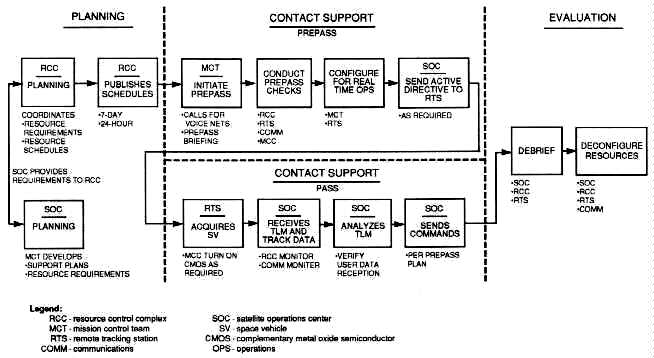
Source: Maj Theodore W. Burgner, "Space Handbook" (Paper provided
as input for revision of
Space Handbook, Operations Training Division, 45th Space Wing , August
1991), 37.
Figure 1. Satellite Support Functional Flow
The planning phase mainly involves activities conducted by the SOC and the RCC. The SOC develops an overall contact support plan (CSP) and identifies what is required to support a particular satellite contact. The CSP includes resource requirements, telemetry parameters, and command and ephemeris data. The SOC may simultaneously prepare multiple satellite support plans. The result of this planning effort is requests by the SOCs and other users to the RCC for AFSCN resources. The RCC then produces a schedule for all AFSCN satellite support based on resources and priorities. There are both long-range and near-term schedules that dictate what resources can support specific satellite passes. Resource scheduling is an ongoing activity. There are opportunities throughout the planning phase to deconflict complex satellite pass support requirements.
The pass support phase includes both prepass and satellite contact time. The SOC, RCC, RTS, and communications elements act in concert to configure all resources, conduct readiness testing, and place the systems into final configuration for the actual satellite support (pass).
The SOC mission control team (MCT) initiates the prepass by requesting that the network communications voice operator establish communications nets. When the operator establishes the nets, the MCT members log on to their respective computer terminals to configure hardware and software. The MCT crew commander provides a briefing over an operations (OPS) communications net and the MCT ground controller (GC) briefs over another communications net, termed the configuration net. The GC briefs the RCC resource controller (RC), the lead communications operator (LCO), the Defense Communications System/Satellite Control Facility Interface System (DSIS) operator, the wideband operator, and the RTS antenna operator on data rates, communications and data channel activity, and overall resource configuration for the particular support. Upon briefing completion, the LCO, DSIS, and wideband operators perform channel checks. The RC then performs commanding, telemetry, and antenna slaving tests. The GC then performs similar readiness testing. During the testing period, all of the above elements are involved in the prepass checks and assist in troubleshooting and reconfiguring, if necessary. The RTS antenna is then positioned in preparation for satellite acquisition. Satellite contact begins when the RTS acquires and tracks the satellite. RTS makes contact by either sending out a turn-on command to activate satellite signals or by simply receiving transmitted satellite signals. The RTS in turn relays satellite telemetry data to the SOC while the RCC and communications elements monitor the operations in progress. The MCT evaluates the telemetry data in real time and verifies user data reception. The MCT may send commands to the satellite via the RTS according to the pass plan. The support ends when the objectives are met and the MCT commander directs the RTS to terminate tracking of the satellite.
The evaluation phase is also the postpass phase. While the communications nets are still operating, the MCT crew commander discusses any support-related problems with the RTS, verifies the next pass time, and calls the network configuration voice operator to terminate the OPS net. The GC discusses any pass-related problems with people on the configuration net and releases the net participants through the RC. When the LCO notifies the RC that resources are normalized, and the MCT crew commander has directed the communications operators (wideband, DSIS, LCO, etc.) to terminate both nets, time-critical postpass activities are concluded, and the RTS and communications links are then available for another support. The MCT may continue such evaluation activities as analyzing payload data, satellite performance, data quality, and orbital parameters.
Remote tracking stations provide the satellite-to-ground interface for satellite command and control; they provide the actual TT&C contact with any space vehicle supported by the AFSCN. The contact is accomplished under the direction of a SOC. The RTS relays satellite telemetry to the control complex, either generates commands for or relays commands to the satellite, and provides tracking data to the control complex. The specific RTS tasks vary depending on the communications interface and the mission. AFSCN RTSs are located worldwide and provide prelaunch, launch and early orbit, and on-orbit TT&C support for assigned US and allied satellites, ballistic missile launches, and the Space Transportation System (STS)--the space shuttle.12
RTSs are strategically located at nine sites with 16 antennas to maximize area coverage for timely and effective use of RTS resources as well as for flexible, multiple support capability (fig. 2). The RTSs are available to control complexes on a time-shared basis for supporting satellite operations and are a scheduled resource. Scheduling is accomplished by the RCC at either Falcon AFB or Onizuka AFB. The RCC allocates time to each RTS for operations, maintenance, and training.
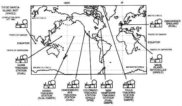
Source: Maj Theodore W. Burgner, "Space Handbook" (Paper provided
as input for revision of
Space Handbook, Operations Training Division, 45th Space Wing , August
1991),24.
Figure 2. Remote Tracking Station Locations
The RTSs within the AFSCN have been modernized as automated remote tracking stations (ARTS). ARTS sites may be a new site, such as the Colorado Tracking Station at Falcon AFB, or a modernized existing RTS site, such as the Vandenberg Tracking Station. All RTSs or ARTSs, while not identical in physical layout, function in approximately the same manner. Some RTSs are configured with additional equipment to support unique missions. We can visualize an RTS's antenna coverage as a cone, widening as the distance from Earth becomes greater. With higher satellite altitudes, a wider selection of RTSs can support a given satellite contact.
RTSs are functionally equivalent to each other and are scheduled for operations based on satellite support needs and the visibility of the satellite to the RTS. Satellite operations events such as TT&C directives, vehicle status and health, and SV commanding data--all pass between the mission control centers and the RTSs over communications links. The RTS uplink transmits satellite command data upload and ranging data. Satellite telemetry and ranging are received in as many as four simultaneous downlinks and transmitted via the communications system to control complexes.
The telemetry function involves tracking in the reception of information on the health, status, and mission payload telemetry of a satellite. An RTS receives satellite telemetry data and transmits this data to a control center. The tracking function involves satellite location and velocity determination. Antenna azimuth and elevation pointing data direct the antenna for satellite acquisition. After acquisition, the RTS transfers range and range-rate data, antenna pointing data, and status information to the control centers, usually via the DSIS. The SOC uses control center tracking data to predict future satellite contacts and to generate antenna pointing data, for real-time acquisition by remote tracking antennas.
The command function includes transmitting coded signals to a satellite to do such things as fire thrusters, start or stop mission tasks, switch power sources, or update sequence programs. The SOC transfers encrypted or clear blocks of command data to the RTS for transmission to the SV. Verification and authentication for each command is normally within the satellite telemetry transmission to the RTS ground antenna and back to the SOC. The SOC then verifies that the satellite properly received the transmitted commands.
Remote Tracking Station Communications. Each RTS has communications capabilities that provide primary and alternate connectivity for data and voice circuits to and from control complexes. One capability is to encrypt and decrypt information and to communicate intrastation via intercom or telephone. Primary communication is accomplished using the DSIS, which links the RTS, via the Defense Satellite Communications System (DSCS) or commercial communication satellites, with either Falcon or Onizuka AFB. Alternate communications links carry digital voice and data, usually on leased commercial telephone circuits, between all AFSCN RTSs and external users. The capabilities of these links vary considerably depending on the support requirements of the different control complexes. An additional communications system used by the AFSCN is called Mission-22 (M-22). It uses DOD host vehicles that are in highly elliptical orbits. Just as the AFSCN is a complex assembly of elements supporting US space assets, the communications links required to carry out the AFSCN mission are a complex suite of networks within and between all elements of the AFSCN and external users. These communications links provide communications security, redundancy, data recording, and interface capability with communications satellites, land lines, fiber optics, and microwave circuits for transmission of data, voice, teletype, and facsimile information.
The wideband communications network provides the primary communications links used in the AFSCN between the control centers and the RTSs. This network uses the DSIS, which links the RTS via DSCS II and DSCS III satellites or commercial communication satellites with either Falcon or Onizuka AFBs. DSIS provides high data rate communications between the RTSs and the control centers. Narrowband communications are an alternative to the wideband system for data and digital voice capability. Additionally, the network uses M-22 communications satellites that provide the capability of minimum essential wideband support in the event of any wideband link outages to any RTS. Some RTSs have a data link terminal (DLT) to specifically utilize M-22. An RTS with two antennas, but no DLT, can still use M-22 for real-time transmission if one antenna tracks, while the other relays data via M-22. The M-22 data rate is limited, but its capability fulfills most present and future vehicle reception requirements.
Remote Tracking Station--Mission Unique Interfaces. RTSs also interface with dedicated elements within the AFSCN in support of specific requirements of the DMSP and GPS programs. Specific mission unique interfaces at the Thule (Greenland), Hawaii, and New Hampshire RTSs provide DMSP support. The RTSs provide an interface for command and telemetry data between the RTSs and the dedicated DMSP elements. The dedicated elements of the DMSP are the Multi-Purpose Satellite Operations Center and the Fairchild Satellite Operations Center. The RTSs provide an interface for primary mission data recovery for transmission to the Air Force Global Weather Central, as well as to the Navy Fleet Numerical Oceanography Center.
A mission unique enhancement at the Colorado Tracking Station (CTS) provides GPS program support. This mission unique interface provides the CTS with a GPS ground antenna command and telemetry processing capability--which allows the GPS SOC at Falcon AFB to directly control the CTS.
There are two command centers in the AFSCN: the Wing Command Post (WCP) located at Falcon AFB and the Group Operations Center (OC) at Onizuka AFB. The WCP exercises operational control over the AFSCN. The OC provides backup functions for the WCP and primary operational control over selected programs specific to Onizuka AFB.13
The Wing Command Post' s primary job is to support the 50th Space Wing commander, providing a command post for the 50th Space Wing and Falcon AFB. The wing commander requires this command post to fulfill responsibilities as the manager and operator of the unique worldwide AFSCN. The WCP also links assigned AFSCN assets into a fully responsive, integrated system supporting multi-service and multi-agency programs and serves as the focal point through which the Air Force Space Command (AFSPACECOM) commander exercises real-time combatant command over AFSCN forces. Some of the functions carried out by the WCP include
1. monitoring and reporting space system health, status, and readiness information of AFSCN elements including dedicated centers and AFSCN mobile resources,2. implementing operations plans and contingency plans,
3. disseminating AFSCN element hostile attack warnings,
4. disseminating intelligence information affecting satellite control operations,
5. maintaining interoperability with the OC, and
6. conducting training exercises, both internally and in conjunction with other elements involved with US space assets.
The 750th Satellite Tracking Group OC, located at Onizuka AFB, serves as a subcenter of the WCP at Falcon AFB. The OC plays an active role in providing downward direction to the RTSs and in channeling information from the RTSs to the WCP. The OC provides a backup capability for command and control of the AFSCN if the WCP cannot sustain its mission. The OC also interfaces with control centers at Onizuka AFB that are dedicated to programs not supported by the AFSCN.
The network control system (NCS) is composed of RCCs located at Falcon AFB and Onizuka AFB. The RCCs provide dual-node resource scheduling capability necessary to support the other elements of the AFSCN. Functional equivalency between the two RCCs allows each complex to perform all AFSCN common-user resource scheduling and resource control functions.14
The NCS mission compromises four different categories: plans and analysis (P&A), resource scheduling (RS), resource control (RC), and inter-range operations (IRO).
The plans and analysis branch collects long-term resource utilization requests for flight preparation and nonflight activities. It then develops long-range forecasts and schedules and distributes them to affected elements. P&A also analyzes resource utilization, system performance, and other associated data.
The resource scheduling branch collects flight resource utilization requests and combines them in a common data base with requests collected by plans and analysis. RS schedules the common-user resources, identifies conflicts, and coordinates conflict resolution in the non-real-time planning period. RS also requests, when necessary, support of internetted resources from appropriate agencies. RS then publishes and distributes the established schedule, performs real-time changes and conflict resolution, and makes data base updates.
The resource control branch configures network common-user resources, conducts prepass and readiness testing, and transfers resource control to the user. RC also monitors resource status and reallocates resources to users in real time as determined by RS. Other RC activities include resuming control of resources released by users, being the focal point for resource outage and restoration status reports, coordinating maintenance activities, and initiating fault localization and isolation testing as required. RC also exercises control over the start, stop, and failure switchover of all scheduled communications link connectivities between the communications control complex (CCC) and AFSCN users.
Interrange operations organizations are located at both Falcon AFB and Onizuka AFB. IRO is the single operational interface through which external space agencies (e.g., NASA) without affiliated SOCs request and obtain support from AFSCN resources. IRO reports operationally to the WCP, but is functionally part of the NCS. IRO obtains early orbit determination and computation of miss-between-orbit data from the Space Defense Operations Center (SPADOC) and provides predictive avoidance data support to SPADOC. The IRO also performs satellite management support and radio frequency interference analyses and predictions.
The NCS consists of hardware, software, personnel, operational procedures, and facilities that interact to provide for scheduling, allocating, configuring, and testing of AFSCN common-user resources. The NCS analyzes resource usage; monitors resource status; conducts fault detection, localization, and isolation for all network resources; and provides the interface for users and resources external to the AFSCN.
The communications control complex is one of the essential control complexes located in the common-user control centers. The CCC performs initiation of circuit connectivity, circuit monitoring, circuit restoration, and fault isolation for AFSCN communications between the common-user control centers and the common-user RTSs. The CCC is also the interface between the AFSCN and external users (for example, NASA). The CCC acts as the interface between the mission and mission support communications services required by the AFSCN.15
Falcon AFB currently does not have primary independent connectivity to the RTSs. An interim configuration called "Backhaul" connects Falcon to the RTSs by going through Onizuka AFB via a domestic satellite link.
The remote communications/telemetry areas (RC/TA) are the remote termination of the mission communications links at the RTSs. The RC/TA performs monitor, circuit restoration, and troubleshooting functions similar to a CCC at a control center.
Primary and alternate communications links internet the AFSCN control centers and the RTSs. These links provide interstation and intrastation communications to common-user elements. Interstation communications consist of primary and alternate communications links connecting control nodes with other AFSCN and external facilities. Intrastation communications distribute data and voice communications within various complexes, control centers, and RTSs.
A number of AFSCN communications functional areas should be highlighted. The recording, storage, and playback area is located at the RTSs and common-user control centers. This area serves as a backup for real-time receive activities and as non-real-time playback for satellite support activities. Types of data involved are primary and backup telemetry, voice, time, and command/control/status signals. The CCC records information by exception; therefore, users must schedule any recording.
The AFSCN communications system provides the necessary interface equipment to permit access between satellite and various terrestrial communications agencies. This area, which includes communications satellite links, interconnect facilities, leased common carrier communications links, and commercial telephone, provides the primary and alternate connectivity between the globally dispersed AFSCN elements.
The Command and Control System (CCS) is the new operating system that was formerly known as Data Systems Modernization. When configured for CCS support, the RTS relays the entire telemetry stream back to a CCS-compatible SOC at either Falcon AFB or Onizuka AFB for telemetry processing. The RTS also relays satellite commands from a CCS SOC to the space vehicle. The Air Force plans to transfer all of its space vehicle operations to the CCS.16
The AFSCN uses two major testing facilities: the Software Development Test Laboratories (SDTL) and the Operational Software Maintenance Complex (OSMC). The OSMC, located at Falcon AFB, provides a software maintenance, testing, and operational support capability for Falcon assets. Capabilities include software maintenance, verification test bed for delivered products, end-to-end system testing, data-base validation, simulation/rehearsal scenario execution, and engineering support. The SDTL located at Onizuka AFB provide similar support functions for the Consolidated Space Test Center (CSTC). This support includes CSTC testing and training support, and software development for newly acquired space vehicle programs to be supported by the AFSCN.17
Force enhancement multiplies combat effectiveness. Space operations contribute directly to the combat effectiveness of our military forces within several mission areas: spacelift, surveillance and reconnaissance, navigation, communications, and meteorology.
Historically, the primary use of United States military space systems has been to support terrestrial forces. From their unique vantage point, satellites can perform and support many military missions more economically, effectively, and efficiently than terrestrial systems. In some cases, satellites are the only feasible means of performing the mission. In addition, the inherent global nature of orbiting satellites makes worldwide support of military operations possible.18
The US military relies extensively on space assets for many critical missions. Force enhancement space systems include capabilities that
Spacelift provides the capability to emplace and replace critical space assets. Spacelift (or launch) operations deliver military space systems to the required operational orbit or location in space. The spacelift mission entails a wide variety of complex activities required to place the satellite into the proper operational orbit.
Spacelift includes preparing the various segments of the space launch vehicle, erecting or stacking the launch vehicle on or near the launchpad, integrating the mission payload(s) with the launch vehicle, conducting a thorough prelaunch checkout of all systems, and conducting the actual operations of countdown, launch, and flight of the space vehicle into orbit.20 Additional detailed information on various spacelift (launch) vehicles is in chapter 4 of this volume.
The following section provides information on two key US space systems that have a long history of success. These systems are only samples of US surveillance and reconnaissance satellite systems. Some of these technologically advanced systems are classified and this volume does not cover them.
Defense Support Program. The Defense Support Program (DSP) is an integral part of the nation's missile warning system operated by the US Air Force Space Command. The satellites report on real-time missile launches, space launches, and nuclear detonations. They have been the spaceborne segment of the North American Aerospace Defense Tactical Warning and Attack Assessment System since 1970.
The vehicle uses infrared detectors that sense the heat from missile plumes against the background of the Earth. The satellite provides secure downlink capabilities to transmit mission data, state-of-health, and other relevant information to the ground data system. The vehicle also provides a secure uplink command receiving, processing, and a distribution capability for both spacecraft and sensor ground-generated commands. The new-generation DSP satellite weighs approximately 5,000 pounds, has a 22-foot diameter, and is 32 feet long with solar paddles deployed. The solar paddles generate 1,485 watts of power. The satellite operates in a geosynchronous orbit, 22,300 nautical miles from Earth. (See annex C [not here] for more DSP information.)
Landsat. Landsat is a civil satellite system developed by NASA to provide land, surface, and ocean data. Initially developed in the late 1960s, the primary Landsat mission was to demonstrate the feasibility of multi-spectral remote sensing from space for practical Earth resources management practical applications. The overall system requirements were acquisition of multi-spectral images (MSI), collection of data from remotely located ground stations, and production of photographic and digital data in quantities and formats most helpful to potential users.21 Another requirement was that Landsat take the data in a specific manner: repetitive observations at the same local time, overlapping images, correct locations of images to within two miles, and periodic coverage of each area at least every three weeks.
Currently, data from Landsat is collected at three US ground stations located in California, Alaska, and Maryland. Through bilateral agreements, ground stations located in Canada, Brazil, Argentina, Japan, India, Italy, Australia, Sweden, and South Africa are also receiving data.22 All data for US consumption is sent to the Goddard Space Flight Center for preprocessing. After preprocessing, the data is transmitted electronically to the Earth Resources Observation System Data Center (EDC) in South Dakota for final processing. The resultant data is then available to users through EDC as photographic imagery or digital data tapes.
Landsat 4 and 5, the second generation of the Landsat series, carry two sensors: a multi-spectral scanner (MSS) and a thematic mapper (TM). The thematic mapper is a new sensor that has a ground resolution of 30 meters for the visible and near-infrared bands.23 The MSS records four images of a scene, each covering a ground area of 185 kilometers (km) by 185 km at a nominal ground resolution of 79 meters.24 The images are produced by reflecting radiance from the Earth's surface to detectors on board the satellite.
Two large applications of Landsat data are mapping land cover and monitoring change, both aquatic and terrestrial. The TM sensor is able to record four times as many radiance levels as the MSS sensor and has better resolution. This enhanced resolution and increased radiance level capability provides greater detail for vegetation absorbance, land/water contrasts, and geological discrimination applications.
The current Landsats take 16 days to cover the Earth (except the poles). Their data is relayed in near real time by using the geostationary Tracking and Data Relay Satellite and the Domestic Communication Satellite systems. This eliminates the need to rely on onboard tape recorders to store data for transmission. As a result, it takes approximately 48 hours from collection of raw sensor data to generation of MSI archival products.25
The Landsat program, originally under NASA, has suffered from a lack of a stable home in the competition between programs for funding. The National Space Council shifted the program to the Commerce Department in 1979 in a commercialization plan that would eventually place it under private ownership and operation. That effort brought in smaller revenues than expected and the program languished. If Landsat 4 and 5, launched in 1982 and 1984 respectively, had not exceeded their three-year-design lifetimes, the US would be without a civil Earth observation spacecraft. Landsat 6, scheduled for launch in mid-1992, should operate for five years, during which time Landsat 7 should be launched.
[Image 36K]
Landsat C
[Image 25K]
Landsat D
The National Space Council decided in December 1991 to build and operate another Landsat after Landsat 6. Landsat 7 will be co-managed by the Department of Defense and NASA. This would mark the first time the Department of Defense has been involved in management of the civilian imaging system. The impetus for this decision can be attributed to the tactical role MSI data played in the Gulf War (see annex A [not here]). Lawmakers, in deciding on this co-management approach, considered the possibility that a data gap could harm global change research, national security applications, and market development.26 The lessons learned concerning MSI data usage during the war will influence the technology for Landsat. Addition of enhanced sensors capable of five-meter stereoscopic images, precise metric data, broad area collection, and a dedicated tracking and data relay antenna would make the Landsat an effective tactical military system for future conflicts.27
[Image 22K]
Global Positioning System Satellite
The Global Positioning System is a space-based radio navigation network operated and controlled from Falcon AFB. The Air Force launched the first research and development satellite in February 1978. As of February 1991, the GPS network consisted of six Block I R&D satellites, and 10 Block II operational satellites. This 16-satellite constellation should grow to 21 satellites plus three on-orbit spares by the mid-1990s.
GPS is a navigation system designed to provide US and allied land, sea, and air forces with worldwide, three-dimensional position and velocity information. The system consists of three segments: a space segment of satellites that transmits radio signals, a control segment of ground-based equipment to monitor the satellites and update their signals, and a user equipment segment of devices to passively receive and convert satellite signals into positioning and navigation information.
When fully operational, GPS will provide 24-hour, all-weather, precise positioning and navigation information from satellites circling the Earth every 12 hours and emitting continuous navigation signals. It will also provide such support to civilian users.
The Air Force launches GPS satellites from Cape Canaveral AFS, Florida, using a Delta II launch vehicle. The satellites are put into 11,000 nautical mile circular orbits. The GPS constellation will have six orbital planes with four satellites in each. Satellites will transmit on two different L-band frequencies. The design life of the operational satellites should be seven and one-half years.
The GPS master control station located at Falcon AFB monitors and controls the GPS constellation. Five widely separated monitor stations passively track the satellites and accumulate navigation signals. Three globally dispersed ground antennas act as the two-way communications link between the MCS and the satellites. Through these links, crews in the MCS update the satellites' computers, allowing them to maintain the health and orbit of GPS satellites, monitor and update navigation signals, and synchronize the satellites' atomic clocks.
GPS data aids land, air, and sea vehicles in navigation, precision weapons delivery, photographic mapping, aerial rendezvous and/or refueling, geodetic surveys, range safety and instrumentation, and search and rescue operations. This system provides military users highly accurate, three-dimensional (longitude, latitude, and altitude) position, velocity, and time information. With proper equipment, authorized users can receive the signals and determine their location within tens of feet, velocity within a fraction of a mile per hour, and the time within a millionth of a second. To obtain this information, the user set will automatically select the four most favorably located satellites, lock onto their navigation signals, and compute the position, velocity, and time.
This section discusses the primary communications satellite systems used by the US Air Force. Communications systems that other services use extensively for specific purposes are not covered in this volume.
[Image 12K]
Defense Satellite Communications System III Satellite
Defense Satellite Communications System. The DSCS provides the DOD, the Department of State, and other US government agencies secure, high-capacity communications that a commercial service or military system cannot provide. The Defense Communications Agency manages operational use of the communications capabilities provided by the network of satellites, ensuring proper allocation of frequency and bandwidth to users based upon their requirements.
In the 1960s the DOD began to build a network of satellites for military communications. This program advanced through three phases incorporating improved technology and enhanced capabilities with each phase.
Between June 1966 and June 1968 in Phase I of the program, the Air Force launched 26 small communications satellites, each weighing about 100 pounds. Each satellite had one channel and relayed voice, imagery, computerized digital data, and teletype transmissions. Designers planned for the satellites to last three years. Phase I satellites operated in a circular orbit 20,930 miles above Earth at a speed that nearly kept each satellite over a point on the equator.
DSCS II launched its first satellites in 1971 and is the second generation military communications satellite program. The 3d Satellite Control Squadron currently flies DSCS II satellites from Falcon AFB. DSCS II has increased communications load capability and transmission strength, and double the lifetime expectancy of the Phase I satellites. DSCS II has an attitude control system for orbital repositioning. Ground command can steer the two-dish antennas on DSCS II satellites and can concentrate the antennas' electronic beams on small areas of the Earth's surface for intensified coverage.
The third generation satellite is the DSCS III satellite. These satellites carry multiple-beam antennas to provide flexible coverage and resist jamming. They last twice as long as DSCS II satellites, have six active communications transmitter channels, and carry an integrated propulsion system for maneuverability. The Air Force launched the first DSCS III satellite in 1982. Antenna design for DSCS III allows users to switch between fixed, Earth coverage, and multiple-beam antennas. The latter provides an Earth coverage beam as well as electrically steerable area and narrow-coverage beams. In addition, a steerable transmit dish antenna provides a spot beam with increased radiated power for users with small receivers. In this way, operators can tailor the communications beams to suit the needs of different size user terminals almost anywhere in the world.28 (See annex A [not here] for more information on DSCS's role in Desert Storm.)
NATO III. The NATO III satellite program is a four-satellite constellation. NATO III satellites are geostationary communications satellites designed to provide real-time voice and data links between members of the North Atlantic Treaty Organization (NATO). The program is directed by the NATO Integrated Communications System Operating Agency (NICSCOA), which is located at Supreme Headquarters Allied Powers Europe, Belgium. The AFSCN performs command and control functions on behalf of NICSCOA.29
NATO III is a cylindrical, spin-stabilized satellite with a design life of seven years. It is 86 inches in diameter, 110 inches in height, and weighs 783 pounds. Solar arrays cover the sides of the satellite body, and there are thermal shields on the top and bottom. The command and control antenna encircles the vehicle, and three communications antennas are atop the satellite on a despun platform. The communications payload is a repeater providing both narrowbeam and widebeam coverage of the North Atlantic region. This payload provides multiple carrier reception, frequency translation, amplification, and retransmission of X-band signals. The apogee kick motor and two axial thrusters are on the bottom of the vehicle. All electronic equipment, the hydrazine tanks, and radial thrusters are on the main equipment platform in the center of the vehicle. The AFSCN launched the NATO III satellites from the Eastern Test Range aboard Delta boosters between April 1976 and November 1984 and placed the four vehicles in elliptical transfer orbits of approximately 23 degree inclination. At approximately fifth apogee, an apogee kick motor fired, circularizing the orbit and reducing the inclination. NATO III will eventually take on a backup mission when NATO IV becomes operational in the early 1990s.
[Image 12K]
Fleet Satellite Communications System Satellite
Fleet Satellite Communications System. The Fleet Satellite Communications System (FLTSATCOM) is a five-satellite constellation. Each satellite has 23 communications channels. The US Navy uses 10 channels for communications among its land, sea, and air forces. The Air Force uses 12 channels as part of the Air Force Satellite Communications System (AFSATCOM) for command and control of nuclear forces. AFSATCOM is not a separate satellite system, but is a functional system imbedded within FLTSATCOM. The last channel is reserved for the NCA.30
The ground segment of the system consists of communication terminals on most US Navy ships and submarines, selected Air Force and Navy aircraft, global ground stations, and presidential networks. Individual users acquire and manage these terminals.
The FLTSATCOM satellites launch from Cape Canaveral AFS, aboard Atlas-Centaur rockets. They are three-axis stabilized in geosynchronous orbit approximately 22,250 nautical miles above the equator. The latest version of the FLTSATCOM satellite and its solid propellant apogee kick motor weighs approximately 4,100 pounds. The vehicle's body is approximately 8 feet in diameter and 65 inches high. The parabolic ultra high frequency (UHF) transmit antenna is 16 feet in diameter when extended; ground command deploys the screen portion of the antenna from its folded launch configuration. A 14-foot long, helical UHF receive antenna, 13 inches in diameter, is mounted outside the edge of the transmit antenna. It is also folded to fit inside the Centaur booster fairing during launch and is deployed by separate ground command. (See annex A [not here] for more information on FLTSATCOM's role in Desert Storm.)
Two deployable solar array panels, which supply approximately 1,500 watts of power, provide the primary electrical power for the satellite. The span of the deployed solar array panels is 43 feet. In addition, three nickel-cadmium batteries provide power during eclipse operations at the spring and autumnal equinoxes. The design life of the satellite is five years.
[Image 20K]
Defense Meteorological Satellite Program Satellite
The Defense Meteorological Satellite Program has been operational since July 1965. Its military mission is to generate weather data for operational forces worldwide. The Air Force is the DOD executive agent for this program. The Department of Commerce's National Oceanic and Atmospheric Administration furnishes meteorological data to the civilian community.
Satellites in the DMSP meet unique military requirements for worldwide weather information. DMSP satellites provide meteorological data in real time to Air Force, Navy, and Marine Corps tactical ground stations and Navy ships. Through these satellites, military weather forecasters can detect developing patterns of weather and track existing weather systems over remote areas.
Data from these satellites can help identify, locate, and determine the intensity of such severe weather as thunderstorms, hurricanes, and typhoons. Agencies can also use the data to form three-dimensional cloud analyses, which are the basis for computer simulation of various weather conditions.
All of this quickly available information aids the military commander in making decisions. For example, data obtained through this program is especially valuable in supporting the launch, en route, target, and recovery portions of a wide variety of strategic and tactical missions. Air Force Space Command's 6th Space Operations Squadron (SOPS) at Offutt AFB, Nebraska, and Detachment 1 of the 6 SOPS at Fairchild AFB, Washington, provide command and control of DMSP satellites.
Current satellites in the DMSP are designated as the Block SD-2 integrated spacecraft system because the functions of the launch vehicle's upper stage and the orbital satellite have been integrated into a single system. This system navigates from lift-off and provides guidance for the spacecraft from booster separation through orbit insertion, as well as electrical power, telemetry, attitude control, and propulsion for the second stage. Block SD-2 has many improvements over earlier DMSP satellites, including more sensors with increased capability and increased life span. The satellites circle the Earth at an altitude of about 450 NM in a near-polar, Sun-synchronous orbit. Each satellite scans an area 1,600 NM wide and can cover the entire Earth in about 12 hours. Three reaction wheel assemblies, which provide three-axis stabilization, maintain pointing accuracy of the satellites. The SD-2 spacecraft has five major sections: a precision mounting platform for sensors and other equipment requiring precise alignment, an equipment support module that encloses the major portion of the electronics, a reaction-control equipment support structure that contains the spent second-stage rocket motor and supports the ascent-phase reaction-control equipment, a solar cell array, and the booster adapter. The Sun-tracking, deployable solar array is covered with 12,500 silicon cells that produce 1,000 watts of power for operating the spacecraft systems. The booster adapter provides electrical interfaces between the satellite and ground test equipment and is the structural interface between the satellite and the booster.
The primary sensor on board the satellite is the operational linescan system that "sees" visible and infrared cloud cover imagery used in analyzing cloud patterns. Also, the spacecraft can carry secondary payload sensors. For example, one sensor measures temperature and moisture; another accurately measures the location and intensity of the aurora to aid radar operations and long-range ground communications in the northern hemisphere, a third measures the precipitating electrons that cause the aurora; a fourth sensor measures X rays, and a fifth sensor measures soil moisture, atmospheric moisture, and sea state.
The normal on-orbit DMSP constellation currently consists of two operational satellites. To date, the DMSP has placed six Block SD-2 satellites on-orbit. Block SD-2 satellites are launched on Atlas-E boosters from Vandenberg AFB, California.
In 1988 Gen Larry D. Welch stated that "spacepower will assume as decisive a role in future combat operations as airpower has today.''31 Aerospace control includes the ability to control the combat environment. Aerospace control is the ability to assure the use of space systems during conflict while denying the enemy the use of his space systems.32 The mission is called counterspace and embodies the idea of space superiority over the battlefield. The ability to achieve and maintain aerospace control has been and continues to be a critical mission of the US Space Command.
Aerospace control is comprised of three mission elements:
Space surveillance is essential to the space control mission and involves the functions and ability to monitor, assess, and inform. The nerve center of United States Space Command's (USSPACECOM) space surveillance mission is the Space Surveillance Center (SSC) located deep inside Cheyenne Mountain AFB, Colorado. A computer network in the SSC keeps a constant record of the movements of thousands of man-made objects orbiting the Earth. These objects include satellites (active and inactive) and pieces of space debris. The SSC computers receive a steady flow of information from the elements of the space surveillance network (SSN). The SSN consists of radars and optical tracking devices located around the world. Specific SSC responsibilities include:
1. Providing operational command and control of the SSN. These activities include tasking of sensors to provide tracking support for routine space catalog maintenance, space object identification, and special events monitoring.2. Maintaining a catalog of orbital characteristics of all observable man-made space objects for position prediction.
3. Providing routine space operations information.
4. Providing orbital data to many users and informing the Space Defense Operations Center of any contributing factors affecting any degradation of performance within the SSN.34
When a sensor acquires a piece of orbiting hardware, it sends the information to the SSC computers. The SSC tracks the present position of these objects and predicts their future orbital paths. The SSC compares the observation with the predicted location of cataloged objects. Observed information which the SSC cannot verify or match with a known object may be an indication of a new or previously uncataloged object in space. It often takes several hours to accumulate enough information to form an accurate mathematical description of an object' s orbit. Orbital elements describe this mathematical model. This set of figures includes the period, inclination, eccentricity, and orientation of the satellite's orbital plane about the equator.35
The SSC generates a Project TIP (tracking and impact prediction) to predict when and where a larger decaying satellite or object will reenter the Earth's atmosphere and then forwards this information to several users. The Missile Warning Center, inside Cheyenne Mountain AFB, uses this information along with other sensor information to assess the potential threat from the object. Many factors make it difficult to predict precisely where and when a satellite or other object will come down. Gaps in the space surveillance network's coverage prevent total surveillance coverage, while atmospheric drag and solar radiation can also influence both the speed and course of an object returning to Earth.36
The center's catalog dates back to 1957 with the Soviet Union's launch of Sputnik I. Since that time, the center has cataloged more than 21,000 objects. Currently, over 7,000 of these objects remain in Earth orbit.37 While the SSC is primarily interested in satellite vehicles (or payloads), it also keeps track of space debris. This includes items such as spent rocket bodies, launch hardware, and other objects from operating satellites. It also includes fragments resulting from in-space breakups of larger objects. In fact, the vast majority of objects now in space are pieces of debris. Although the SSC has the ability to track and monitor thousands of pieces of debris, many go undetected because of their minute size. It is possible that tiny pieces of debris, the size of paint flecks, may actually number in the millions.
The SSC also has a backup operations center, the Alternate SSC or ASSC. The ASSC is part of the Naval Space Surveillance (NAVSPASUR) system in Dahlgren, Virginia. The ASSC maintains the satellite catalog when the computational capability or the command and control capability of the SSC fails to function properly.
The USSPACECOM uses a worldwide network of sensors, collectively called the SSN, to perform the mission of keeping track of space objects orbiting the Earth. (The SSN is a network separate from the AFSCN. The SSN supports the space control mission, while the AFSCN supports the space support mission.) The SSN reports to the Space Defense Operations Center and is comprised of three different types of sensor systems: dedicated sensors, collateral sensors, and contributing sensors.38
Dedicated Sensors. Dedicated sensors support the space surveillance mission. They include three unique optical systems, a combined radio frequency (RF) and optical system, a phased array system, a mechanical tracker radar, and a "radar fence" operated by the Navy.
The ground-based electro-optical deep space surveillance system (GEODSS) is an optical system that uses a low-light-level TV camera, computers, and large telescopes. GEODSS tracks objects in deep space, or from about 3,000 NM out to beyond geosynchronous altitudes. GEODSS requires nighttime and clear weather tracking because of the inherent limitations of an optical system. There are currently four operational GEODSS sites with coverage areas as follows: Socorro, New Mexico (165W-050W); Maui, Hawaii (140E-010W); ChoeJong San, South Korea (070E-178E); and Diego Garcia, Indian Ocean (010E-130E). Each site has three telescopes, allowing GEODSS to track three objects simultaneously. All three telescopes are linked to video cameras. Two of the three telescopes are 40-inch aperture main telescopes, which are used primarily to search the deep sky for faint, slow-moving objects. The other, a 15-inch telescope, does wide searches of lower altitudes where objects travel at higher relative speeds. The only exception to this configuration is the Diego Garcia site, which has three 40-inch telescopes. The television cameras feed their space pictures into a computer that drives a display device. The computer automatically filters stars from the night sky backdrop, and the satellites appear on the display screen as streaks of light. GEODSS can transmit position and identification signature data to the SSC (in Cheyenne Mountain) in seconds. GEODSS sensors are responsible for over 65 percent of all deep space object tracking and surveillance, and provide almost worldwide coverage of the equator. Any sustained loss of a GEODSS sensor would have dramatic impact on the deep space surveillance mission and maintenance of the space catalog.39
The second optical system is the Maui Optical Tracking and Identification Facility (MOTIF) in Hawaii. MOTIF is a dual 1.2-meter telescope system on a single mount. One telescope primarily does infrared and photometric collection. The other performs low-level light tracking and imagery. MOTIF can track space objects in near-space and deep-space orbits and represents AFSPACECOM's sole long-wave infrared imaging capability. Like GEODSS, MOTIF is limited to night operations. MOTIF is also hindered by high winds, high humidity, cloud cover, and a bright Moon.40
The third and final optical system under the dedicated sensors of space surveillance is the combined RF/optical surveillance system (CROSS). CROSS is located at San Vito, Italy, and replaced the previous Baker-Nunn system. CROSS improves eastern hemisphere deep space coverage. Like its optical counterparts, CROSS is a passive sensor and is constrained by weather, field of view, and daylight. However, unlike its optical counterparts, it benefits from its capability to use radio frequencies to search out active satellites in deep space. (For additional information on CROSS and other passive RF sensors, such as the deep-space tracking system and the low-altitude surveillance system, see annex B. [not here])
The remaining dedicated sensors are all radars: a phased array system and a continental United States (CONUS) radar fence operated by the US Navy. The Air Force has one phased array radar (UHF, FPS-85) located at Eglin AFB, Florida. This radar operates in the 437-447 megahertz (MHz) frequency range and has the capability to track both near-earth and deep-space objects simultaneously with extreme sensitivity. In fact, the Eglin AFB radar can provide 10,000 observations per day on space objects--the equivalent of 14 mechanical trackers or three PAVE PAWS sensors. Eglin AFB also maintains the radar cross section catalog for the SSN. The four PAVE PAWS sensors use the Eglin radar's observations to assist in tracking space objects.41
The final dedicated sensor is the NAVSPASUR system. Operated by the Navy, NAVSPASUR is an electronic "fence" stretching 3,000 miles across the southern United States from Georgia to California and extending 1,000 miles off each coast. The fence consists of three powerful transmitters and six receivers. The transmitters are located at Lake Kickapoo, Texas; Gila River, Arizona; and Lake Jordan, Alabama. The receivers are in San Diego, California; Elephant Butte, New Mexico; Red River, Arizona; Silver Lake, Mississippi; and Hawkinsville and Tattnall, Georgia. Each transmitter station sends out a continuous wave of radio energy in a fan-shaped pattern, with a very narrow north-south dimension and a wide east-west spread. This creates the fence, an overall vertical east-west fan of radio energy extending thousands of miles into space. An object passing through the beam reflects energy back to the receivers. The receiver stations then measure the reflected satellite signal and send their data to the NAVSPASUR Operations Center at Dahlgren. The center processes the data to determine the object's precise location and relays this information to the SSC.42
[Image 13K]
PAVE PAWS
Collateral Sensors. Collateral sensors have a primary mission other than space surveillance, but still provide support to the space surveillance mission. Collateral sensors include the following systems:
System |
Type |
Site |
| BMEWS
|
Phased Array Radar
Phased Array Radar Mechanical Tracking Radar |
Thule AB, Greenland
RAF Fylingdales Moor, Clear AFB, Alaska |
| PAVE PAWS
|
Phased Array Radar
|
Cape Cod, Massachusetts
Robins AFB, Georgia Eldorado, Texas Beale AFB, California |
| PARCS | Phased Array Radar | Cavalier AFS, North Dakota |
| RADINT
|
Phased Array Radar (Cobra Dane) Mechanical Tracking Radar |
Shemya, Alaska Pirinclik, Turkey |
The ballistic missile early warning system (BMEWS) sensors contribute to the space surveillance mission. These sensors are somewhat limited in the performance of the space surveillance mission since planners designed each radar primarily to perform a missile warning mission as opposed to the spacetrack and identification mission. Each radar is unique in its ability to contribute to the space surveillance mission. For example, the perimeter acquisition radar attack characterization system (PARCS) sensor currently contributes over 15 percent of the observations used to maintain the spacetrack catalog. However, due to the geographic location and positioning of its one-face phased array radar, PARCS does not play a significant role in new foreign launch (NFL) processing, nor is it able to track a significant portion of deep-space objects.
Unlike the other collateral sensors, Cobra Dane and Pirinclik have primary missions of intelligence data collection. Cobra Dane is a single-faced phased array radar (AN/FPS-108) at Shemya AFB, Alaska. Located on the far end of the Aleutian Island chain and less than 500 miles from Kamchatka Peninsula, Cobra Dane is perfectly situated for its primary mission of collecting technical radar intelligence (RADINT) data on intercontinental ballistic missile (ICBM)/submarine-launched ballistic missile (SLBM) test launches into the Kamchatka Peninsula and the Pacific Broad Ocean Area. Cobra Dane's corollary mission is to provide tactical warning and attack assessment of ICBM/SLBM attacks on the CONUS and southern Canada. As a space surveillance sensor, Cobra Dane is the most important NFL ground sensor and is usually the first US radar to track Soviet space launches. Operating in the L-band range, Cobra Dane uses both a wideband (1,175-1,375 MHz) and a narrowband (1,215-1,250 MHz) frequency to provide better accuracy and sensitivity than PAVE PAWS sensors. Its wideband capability is well suited for mission payload assessment. Cobra Dane is currently undergoing a system modernization program to update its hardware and software. Scheduled for completion in the fall of 1993, this upgrade will improve its data collection and replace aging data processing equipment.43
The Pirinclik, Turkey, RADINT site operates both a detection radar (AN/FPS- 17) and a mechanical tracking radar (AN/FPS-79). Both radars operate at an UHF (432 MHz) frequency. Although limited by their mechanical technology, Pirinclik's two radars give the advantage of tracking two objects simultaneously in real time. Its location close to the southern Soviet Union makes it the only ground sensor capable of tracking actual deorbits of Soviet space hardware. In addition, the Pirinclik radar is the only 24-hour-per-day eastern hemisphere deep-space sensor.
Finally, another set of collateral sensors include three mechanical tracking C-band radars: Antigua, British West Indies, Kaena Point, Hawaii, and Ascension Island in the Atlantic Ocean. These radars are located on islands and primarily support test and evaluation of US ICBM and space launches. The three radars spend approximately 128 hours per week supporting the space surveillance mission. Antigua's position in the northern hemisphere near the equator allows accurate coverage of all low-Earth orbits; however, as a tracking radar, Antigua's FPQ-14 radar (operating between 5,400-5,900 MHz) has a limited search capability. Kaena Point's radar is nearly identical to Antigua's (operating in the same frequency range with a narrow beam width) providing accurate data with limited search capability. The final C-band radar, a TPQ-18, located on Ascension Island in the southern hemisphere near the equator, provides accurate coverage of all low-Earth orbits. In addition to this radar on Ascension, the US Navy is currently upgrading an FPQ-15 radar. When completed, this new radar will function in the X-band (8,000-12,500 MHz) frequency range and provide more accurate coverage.44
Contributing Sensors. The final group of sensors are referred to as contributing sensors. These sensors are not under USSPACECOM's operational control; however, they provide observation data on satellites to USSPACECOM on a contributing basis. There is a total of five contributing sensors: four mechanical tracker radars and one electro-optical sensor. One mechanical C-band tracker, located at Kwajalein Atoll, Marshall Islands, tests and evaluates US ICBMs. The ALCOR radar, one of two radars located on Kwajalein Atoll, provides wideband imagery data at 5,672 MHz and can be used for near-Earth surveillance to meet USSPACECOM requirements. Also located on Kwajalein Atoll, is the ALTAIR A-B band radar (4l5-450 MHz). USSPACECOM uses this radar about 128 hours per week.45
There are two contributing sensors located at Tyngsboro, Massachusetts. The Haystack radar, an X-band radar, operates at 10 gigahertz and is the only wideband radar in the western hemisphere able to image in deep space. Haystack operates eight scheduled five-day sessions and two recalls per year. (A recall requires four to eight hours to reconfigure equipment.) The other contributing sensor at Tyngsboro, is the Milistone L-band radar, operating at 1,295 MHz. Milistone is contracted by the USAF for about 80 hours per week.
The final contributing sensor is the Air Force Maui Optical Station (AMOS). AMOS has an electro-optical system collocated with MOTIF and GEODSS on Maui, Hawaii. AMOS, with a 63-inch telescope, is a test bed for new surveillance systems and provides an infrared signature data base for space objects. Like other optical systems, AMOS is limited to night operations and is hindered by adverse weather conditions.46
In addition to the ability to protect friendly space assets, often referred to as space defense, is another mission--defensive counterspace. Currently, such passive means as electronic hardening of satellites and addition of fuel for potential avoidance maneuvering are used to protect space-based assets. The mission is characterized by an extensive battle management (BM)/command, control, and communications (C3) capability to direct the space defense of friendly space assets and thereby achieve space control. The principal component of the BM/C3 capability is the Space Defense Operations Center.47
The Space Defense Operations Center (SPADOC) is located in Cheyenne Mountain and serves as a fusion center for the space control mission. SPADOC is responsible for protecting DOD, US civilian, and allied nation space systems. SPADOC fulfills its mission responsibilities primarily through monitoring space and space-related activities, informing members of the space community of unique space-related events, and planning possible defensive countermeasures.48 To achieve its objectives, SPADOC specifically monitors and reports abnormal or unusual space activity, and recommends the necessary follow-on steps to specific organizations. SPADOC also analyzes possible threat attack information, determines the time and location of the attack, and identifies both the space system under attack as well as the method and type of attack taking place. Finally, SPADOC advises specific organizations of which US space systems are vulnerable to attack or are likely to be targeted for attack.
SPADOC communicates with organizations owning or operating space-based systems through various secure and unsecure communications means. SPADOC, a key center of operations under USSPACECOM, routinely communicates with other USSPACECOM operations centers and component commands for routine status information. In the event of a space threat, SPADOC will communicate directly with specific satellite system owners/operators to preclude delay in transmission of critical warning messages.49
The primary method of secure connectivity between SPADOC and all space system owners/operators is the Space Defense Command and Control System (SPADCCS). SPADCCS is a communications network using hard copy messages to and from SPADOC and space system owners/operators.
The final space control mission--offensive counterspace--is categorized by the term negation. The ability to negate or destroy any hostile space system includes the use of an antisatellite (ASAT) system. The US does not currently operate a functional ASAT system. Any future system will serve as an integral part of USSPACECOM's plan to achieve total space control.
An operational ASAT force would fulfill many objectives of space control. Operational ASATs would encourage the right of free passage through space, increase the options available to US commanders--especially during major war-fighting operations--and provide the capability, if required, to attack enemy military space assets to ensure space superiority and control of the high frontier. A comprehensive ASAT system would most likely consist of directed energy weapons, kinetic energy weapons, and possibly electronic warfare systems.50
This section provides a broad overview of ballistic missile defense (BMD) planning as outlined by the Strategic Defense Initiative Organization (SDIO). The discussion includes a review of BMD concepts, an overview of the global protection against limited strikes (GPALS) concept, and a look at a potential GPALS architecture. The section concludes with a discussion of follow-on systems showing how a GPALS system could evolve into a stronger form of ballistic missile defense.
In the 1980s a technologies study (Fletcher study) concluded that the most effective strategic defensive systems would have multiple layers. The concept of multilayered defense continues to be the conceptual cornerstone of GPALS. Specifically, the GPALS system consists of layers referred to as boost/postboost, midcourse, and terminal.
These layers exist when considering defense against strategic and theater ballistic missiles with ranges greater than a few hundred miles. Some shorter range missiles may have trajectories that remain in the atmosphere and are too low to permit intercept from space. Such missiles would be susceptible to ground-based defenses, including anti-tactical ballistic missile defenses.52
The phenomenology and required technologies for defense differ from layer to layer. However, the basic BMD system functions remain the same:
1. detection, acquisition, tracking and discrimination;2. interception and destruction of threatening objects; and
3. communications, battle management, command, and control.53
As new technologies emerge, they can provide better ways to accomplish the essential functions in defensive layers without changing the overall system concept. These technologies involve both space- and surface-based defensive weapons along with their associated sensors and command and control capabilities.54
For multiple ballistic missiles with multiple RVs, the region that potentially has the highest defense payoffs is the boost/postboost layer. Viable technical approaches now exist for intercepting from space a ballistic missile during the boost portion of its flight. Inclusion of boost-layer defense would substantially discount the value of ballistic missiles with multiple independently targetable reentry vehicles (MIRV) and provide the threatening forces with incentives to accomplish the long-standing arms control objective of reducing MIRVed ICBMs. Intercepts in the boost phase also offer multiple engagement opportunities to ensure high levels of defense effectiveness. The synergism provided by layers of the defense significantly increases the task of designing and deploying effective offensive countermeasures.55
If missiles have fast-burn boosters to counter initial boost-layer defenses, the task of releasing decoys is more complicated, mitigating the requirement to design means of discrimination in the midcourse layer. Furthermore, follow-on defensive system concepts could block the fast-burn approach. Intercepts in the boost/postboost layer can also destroy the post-boost vehicle (PBV) before it releases decoys and other penetration aids designed to confuse the defenses, should such decoys and penetration aids be present.56
The major technical challenge in the midcourse layer is to develop a capability to discriminate RVs from accompanying decoys or other penetration aids. For example, using sensors in space to observe the operation of a PBV as it starts to release its payload could permit early identification of RVs among the clouds of decoys. This early identification in turn, could mitigate the problems associated with tracking and intercepting RVs from either space or the surface.57
In the terminal layer, the atmosphere helps the defense discriminate because atmospheric drag would decelerate heavy RVs less than their accompanying lighter penetration aids. The key technical challenges for endoatmospheric interceptors are accommodating the severe heating caused by friction with the atmosphere and achieving a high degree of maneuverability.58
In his State of the Union Address on 29 January 1991 President Bush stated:
Now, with remarkable technological advances like the Patriot missile, we can defend against ballistic missile attacks aimed at innocent civilians. Looking forward, I have directed that the SDI [Strategic Defense Initiative] program be refocused on providing protection from limited ballistic missile strikes, whatever their source. Let us pursue an SDI program that can deal with any future threat to the United States, to our forces overseas, and to our friends and allies.59
The president's remarks provide the basis for the GPALS mission objective. This objective is to provide protection against accidental, unauthorized, or limited ballistic missile strikes by third world countries or the Commonwealth of Independent States directed against US power projection or forward deployed forces, US friends and allies, and the United States itself.60
Accidental and Unauthorized Strikes. While the requirement for the US to deter a strategic nuclear attack remains, the evolving world situation also leads to a requirement for protection against limited strikes by ballistic missiles. BMD planning and any design of a GPALS system must take into account the possibility of unauthorized or accidental launches, whatever the cause or source.61
The concern for accidental and unauthorized launch increases with the proliferation of ballistic missiles. Concern that loss of positive control over ballistic missile forces might occur in third world countries is real due to their lack of experience with weapon systems, nonexistent or inadequate weapon release procedures, absence of adequate physical and organizational safeguards, and the possibility of political instability.62
The spread of missile technology of increasing sophistication and destructiveness is a trend that the US must consider as it develops military forces to be fielded in the 1990s. A prime example of this spread is the proliferation of ballistic missiles and weapons of mass destruction, including the capability to design, test, and fabricate chemical, biological, and nuclear weapons. One of the factors that mandated refocusing of the Strategic Defense Initiative program is the increased threat posed by the spread of ballistic missile capabilities around the world.63
These technologies pose a threat today that is regional in character (e.g., shorter-range missile systems). However, the trend is clearly in the direction of systems of increasing range, lethality, and sophistication.64 The SDIO has assessed the proliferation of ballistic missiles and found that by the year 2000, some 24 nations will have a ballistic missile launch capability. Figure 3 represents an illustrative look at ballistic missile proliferation.65
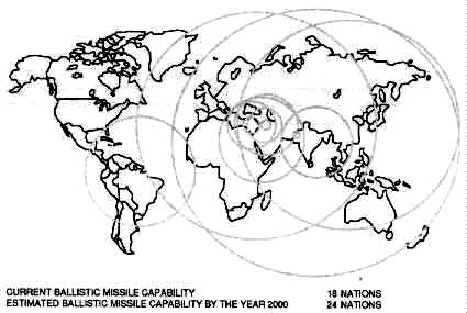
Source: Strategic Defense Initiative Organization,
1991 Report to the Congress on the Strategic Defense Initiative (May
1991), 1-5
Figure 3. Current Third Country Ballistic Missile Capability
It is clear that some third world countries are striving to acquire or develop missiles capable of delivering payloads primarily at short and medium ranges, although a few countries could achieve intercontinental ranges through the conversion of space launch vehicles. This is a matter of concern in a world that may be increasingly affected by diverse geopolitical considerations.66
According to the SDIO, the US cannot accept a situation in which these capabilities are allowed to constrain US national objectives, including US global and regional interests and responsibilities. Proliferation of ballistic missiles is a growing threat to the United States, its armed forces, and allied nations around the world.67
Elements of Global Protection against Limited Strikes. GPALS would consist of surface- and space-based elements to ensure continuous global detection, tracking, and intercepting of ballistic missiles and their associated warheads, including theater missile threats. The defensive elements that would comprise GPALS could be deployed sequentially and need not await the deployment of an entire system. Nor would the deployment of a GPALS system be contingent on the technical maturity of potential follow-on systems.
A GPALS system would consist of surface- and space-based sensors capable of providing continuous, global surveillance and tracking from launch to intercept or impact of ballistic missiles of all ranges. The use of space-based sensors would allow for a reduction in the size, cost, and number of surface-based weapons and sensors, while increasing their performance. In combination, the sensors would provide information to US forces and potentially to those of allies as well.
A GPALS system would also contain interceptors, based both in space and on the surface, capable of providing high-confidence protection to areas under attack. Space-based interceptors could provide a continuous, global interdiction capability against missiles with ranges in excess of 600 kilometers. The surface-based interceptors (located in the US, deployed with US forces, and potentially deployed by US allies) would provide local point and area defense.68
To illustrate the GPALS concept, figure 4 depicts an integrated system consisting of three interlocking pieces.69 The size of each piece reflects the relative investment projected for the three main parts of the GPALS. Specific elements are discussed under the section on GPALS architecture.
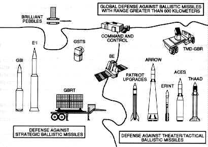
Source: Strategic Defense Initiative Organization,
1991 Report to the Congress on the Strategic Defense Initiative (May
1991), 1-8
Figure 4. GPALS Integrated System and Key Elements
Common to all GPALS interceptors is the use of non-nuclear, hit-to-kill interceptor technology for destruction of all types of warheads--nuclear, chemical, biological, and conventional. These interceptors permit destruction of both the missile and the warheads well away from the targets being defended. The employment of multilayered defense will ensure multiple opportunities to engage hostile ballistic missiles, thereby providing a high level of defense effectiveness.70
The theater/tactical element of GPALS will be able to be deployed globally by the United States. These forward elements of our ballistic missile defense will be transportable and could deploy with ground- or sea-based units. Friends or allies may also choose to deploy theater defenses that could be interoperable with those of the US. It is important to note that the space-based ballistic missile defense sensors will support theater as well as strategic defense operations.71
The discussion in this section addresses the complete GPALS architecture to defend against limited ballistic missile attacks regardless of their source. Both surface- and space-based elements are included in the GPALS architecture.72
Given US experience with theater ballistic missile threats in the Persian Gulf War and the fact that these threats will become more sophisticated in the future, the US is pursuing development and deployment of advanced theater defenses by the mid-1990s as an urgent priority. These ground-based theater defense interceptor systems would provide midcourse and terminal defense capability. Interceptors could be based in-theater continuously (or moved to hot spots as needed), on ships, or on aircraft.
These interceptor systems would be cued and supported by space-, air-, and ground-based sensors.73
Brilliant Pebbles. The space-based Brilliant Pebbles (BP) element in combination with a ground-based command center is illustrated in figure 5. Brilliant Pebbles, after receiving weapon-release authority, would be an autonomous space-based kinetic energy interceptor. BP would provide global detection of an attack and means to destroy ballistic missiles with ranges greater than 600 kilometers. In the GPALS architecture, BP would operate against both strategic and theater ballistic missiles. Current plans call for about l,000 BPs to support a GPALS architecture.74
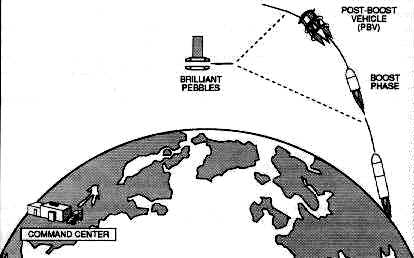
Source: Strategic Defense Initiative Organization,
1991 Report to the Congress on the Strategic Defense Initiative (May
1991), 2-5
Figure 5. GPALS Architecture: Space-Based Protection against Ballistic
Missiles with a Range Greater than 600 Kilometers
Developing space-based BP interceptors as part of GPALS is important for the following reasons:
1. BP interceptors would have the potential for continuous worldwide coverage.2. The sensing capability of BP will provide additional tactical warning information to the national command authorities in the event of a ballistic missile attack, as well as provide cueing to elements of the GPALS system and to the Brilliant Eyes (BE) satellites.
3. BP would exploit US technological strengths and would provide leverage both against proliferation of theater ballistic missiles of longer ranges and in arms control negotiations (e.g., to provide incentives for a nation to move away from MIRVed strategic forces).75
BP would obtain its greatest leverage as a boost/postboost interceptor. It would be designed to detect a launch with its infrared sensor, track the hot plume, compute the trajectory, then home in on the heat signature. BP also has the potential to engage theater ballistic missiles, depending on the characteristics of such missiles (e.g., their burn time and apogee of ballistic flight) and on the BP design, basing, and operations concept.76
However, BP would not be able to reach some theater and tactical ballistic missiles during boost because their burn time is too short and their burnout altitude is too low. For these and other single-warhead missiles, BP would be able to use precise tracking of the booster trajectory during powered flight to project ahead to an intercept point in space. The BP could fly toward this point and with currently planned sensor capability, acquire the target from sufficient range, even when dark, and home in to intercept.77
The US is studying the role of BP in the midcourse layer. BP could have a greater midcourse capability against limited attack than against a massive strike. First, a limited strike is not anticipated to include preemptive antisatellite strikes. This means that survivability requirements would differ significantly between the two situations. Second, because the number of threat objects in a limited strike scenario is anticipated to be a fraction of what would be included in an all-out mass strike, the need for discrimination of RVs from penetration aids would be less acute.78
US Ground-Based Defense. Figure 6 depicts the architecture for ground-based defense against strategic ballistic missiles. The ground-based architecture consists of a command center and a combination of Brilliant Eyes satellites, terminal phase ground-based radar trackers (GBRT), and high-speed accurate interceptors. These interceptors would be terminal phase endo-exoatmospheric interceptors (E2I) and/or midcourse phase exoatmospheric ground-based interceptors (GBI). An option also exists to add the ground-based surveillance and tracking system (GSTS) to the architecture. BE satellites are derivatives of the previously planned space-based surveillance and tracking system satellites. The E2I is a derivative of the previous high-endoatmospheric defense interceptor.79
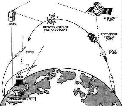
Source: Strategic Defense Initiative Organization,
1991 Report to the Congress on the Strategic Defense Initiative (May
1991), 2-7
Figure 6. GPALS Architecture: Ground-Based Protection
against Strategic Ballistic Missiles
For planning purposes, the ground-based defense tier of a GPALS system includes the following:
1. approximately 750 ground-based interceptors,2. six ground-based radars,
3. approximately 60 BE satellites, and
4. the appropriate command and control for the ground-based tier.80
If E2Is are used, BE would provide postboost and midcourse surveillance and GBRTs would support terminal intercepts. The BE satellite would track the PBVs, clusters of RVs, and, in some cases, individual RVs to provide the data to commit the E2I. The GBRT would acquire, track, and discriminate between RVs and decoys in the late midcourse and terminal portions of their trajectories, providing kill assessment and additional target selections to the E2I.81 If GBIs are used, either BE, GSTS, or some combination of each will be used to provide cluster tracks for the GBIs. GBIs may require GBRT for commitment against short time of flight SLBM, but this requirement remains to be validated as the program matures.82
The choice between E2I and GBI, or possibly whether to continue with both, will be made before full-scale development and will depend on the resolution of several issues at that time. Terminal defense could benefit from the easier discrimination of RVs from decoys by atmospheric slowdown, but only, at the expense of requiring a more complicated interceptor that could withstand the heating and mechanical stress caused by operating in the upper atmosphere. Midcourse interceptors are inherently simpler and could be used much more flexibly throughout the long midcourse portion of the RVs' flight trajectory. However, the defense must have confidence in its ability to discriminate RVs in midcourse in the expected threat environment.83
The same elements discussed above would counter SLBM attacks. The functions of the elements would be very similar to those performed in defending against ICBMs. This capability is shown in figure 7. However, an SLBM attack launched from a submarine very close to the US coast would constitute a more stressing threat, especially if flown on a depressed trajectory. Although BP would be effective against such an attack, those RVs not engaged by BP would have to be intercepted by ground-based interceptors to completely counter such an attack.84
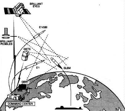
Source: Strategic Defense Initiative Organization,
1991 Report to the Congress on the Strategic Defense Initiative (May
1991), 2-8
Figure 7. GPALS Architecture: Protection against SLBMs
The complete GPALS system is portrayed in figure 8. The effectiveness, survivability, and testability of this architecture are possible in large part because of the autonomy of its constituent parts.85
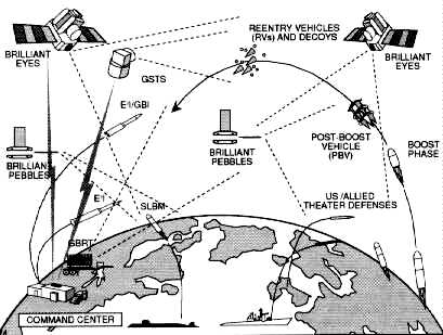
Source: Strategic Defense Initiative Organization,
1991 Report to the Congress on the Strategic Defense Initiative (May
1991), 2-9
Figure 8. Complete GPALS Architecture
The selection of an evolutionary path towards building and deploying the GPALS architecture is critical. In the future, more capable defenses will also require the selection of an evolutionary approach. This advanced defense capability depends heavily on how the threat may change, the mission desired, and the technologies available and their costs.86
The SDI program has examined a variety of concepts for advanced weapon and sensor elements, is developing the required technologies to support them, and has analyzed possible follow-on architectures. Preliminary observations suggest that if the US makes a decision to expand defense objectives beyond GPALS it could:
GPALS would add these two improvements, either sequentially or concurrently, to provide the capability to interactively discriminate RVs from decoys and other penetration aids during the midcourse phase of ballistic missile flight. They could also provide multiple capabilities to destroy boosters, PBVs, and RVs. Choices for missions, directed energy development timing, and directed energy types depend on the nature and timing of threat changes that require expansion beyond GPALS.87
Another promising element under investigation is the hypervelocity gun for situations that require high firepower. Also under study is the possibility of combining the inherent sensor capabilities of different weapon platforms. Such combinations could yield a more complete picture of the battle, thereby enhancing the effectiveness of the architecture and possibly reducing certain technical requirements for the weapons.88
1. "Space Operations Functions," vol. 10, course materials for ACSC (Maxwell AFB, Ala.: Air Command and Staff College, 1991), 60; and Lt Col Steve Malutich and Maj Jim Dill, "Space Support," vol. 10 (Maxwell AFB, Ala.: Air Command and Staff College, 1991), 61-64, 67.
2. Maj Theodore W. Burgner, "Space Handbook" (Paper presented as input for revision of Space Handbook, 45th Space Wing Operations Training Division, August 1991), 12.
3. Ibid., 14.
4. Ibid., 12.
5. Ibid., 13.
6. Ibid., 14.
7. Ibid., 12-14.
8. Ibid., 34-35.
9. Ibid., 16-18.
10. Ibid., 36-39.
11. Ibid., 23-29.
12. Ibid., 15.
13. Ibid., 18-20.
14. Ibid., 29-33.
15. Ibid., 22.
16. Ibid., 21.
17. Ibid.
18. AFM 1-6, Military Space Doctrine, 15 October 1982, 63.
19. Burgner, 44-45.
20. Ibid., 46.
21. Nicholas M. Short, The Landsat Tutorial Workbook (Washington, D.C.: NASA, 1982), 409.
22. House Committee on Science and Technology, Civil Land Remote Sensing System, 97th Cong., 1st sess., 1982, Committee Print, 9.
23. H. S. Chen, Space Remote Sensing Systems (San Diego, Calif.: Academic Press, Inc., 1985), 216.
24. Paul J. Curran, Principles of Remote Sensing (New York: Longman, 1985),141.
25. Short, 417.
26. Patricia A. Gilmartin, "France's Spot Satellite Images Helped U.S. Air Force Rehearse Gulf War Missions," Aviation Week & Space Technology, 1 July 1991, 22.
27. Ibid.
28. Burgner, 46.
29. Ibid., 48.
30. Ibid., 46 47.
31. James W. Canan, "Normalizing Space," in Space the Fourth Military Arena, ed. Connie Sessions and Gwen Story (Maxwell AFB, Ala.: Air University, 1992), 239.
32. AFM 1-1, Basic Aerospace Doctrine of the United States Air Force, vol. 1, March 1992, 9.
33. Ibid.
34. Capt Larry Jacks, "Space Surveillance Network," 1 SWG/DOOS paper, June 1991,1.
35. Ibid., 2.
36. Ibid.
37. Ibid., 3.
38. Ibid., 4.
39. Ibid., 5.
40. Ibid., 6.
41. Ibid., 7.
42. Ibid., 8.
43. Ibid., 8-9.
44. Ibid., 10.
45. Ibid.
46. Ibid., 11.
47. Maj Steven R. Petersen, Space Control and the Role of Antisatellite Weapons (Maxwell AFB, Ala.: Air University Press, May 1991), 63.
48. Ibid., 66-67.
49. Ibid., 67.
50. Ibid., 69-70.
51. Strategic Defense Initiative Organization, 1991 Report to the Congress on the Strategic Defense Initiative (May 1991), 2-1.
52. Ibid.
53. Ibid.
54. Ibid.
55. Ibid.
56. Ibid., 2-1, 2-2.
57. Ibid., 2-2.
58. Ibid.
59. Ibid., 1-1.
60. Ibid., 2-2.
61. Ibid., 1-4.
62. Ibid.
63. Ibid.
64. Ibid.
65. Strategic Defense Initiative Organization, The President 's New Focus for SDI: Global Protection against Limited Strikes (10 April 1991), 2.
66. SDIO, Report to Congress, 1-5.
67. Ibid.
68. Ibid., 1-7, 1-8.
69. Ibid., 1-8.
70. Ibid.
71. Ibid.
72. Ibid., 2-2.
73. Ibid., 2-3.
74. Ibid., 2-6.
75 . Ibid., 2-5 .
76. Ibid., 2-6.
77. Ibid.
78. Ibid.
79. Ibid.
80. Ibid.
81. Ibid.
82. Ibid.
83. Ibid., 2-7.
84. Ibid.
85. Ibid.. 2-8.
86. Ibid.
87. Ibid., 2-9.
88. Ibid., 2-10.
_____________________________________________________
Spacelift, assigned to Air Force Space Command (AFSPACECOM) in October 1990, is the command's newest operational mission. To get a clearer idea of what spacelift is, we must first look at a definition of the mission. Air Force Manual 1-1, Basic Aerospace Doctrine of the United States Air Force, states that "spacelift projects power by transporting people and materiel to and through space.''1 Therefore, spacelift's objective is to launch and deploy new and replenishment space forces at any level of conflict.2 Spacelift is accomplished by a joint ensemble of military, civil service, and civilian contractor personnel. They process, integrate, assemble, analyze, and launch today's space launch vehicles. These vehicles and the launch bases used today were, for the most part, developed in the 1950s and 1960s. But, as Vice President Dan Quayle stated in his fall 1991 announcement of the new National Launch Strategy:
The current systems are not obsolete. Systems like the Atlas, Delta, Titan, and the Space Shuttle will continue to provide the nation's primary launch capabilities at least through the end of the decade and into the 21st century.3
This chapter presents the major areas of spacelift. The discussion includes an overview of major launch vehicles and a short look at the launch process.
US launch bases consist of two major facilities operated by Air Force Space Command. Cape Canaveral Air Force Station (AFS), Florida, and Vandenberg Air Force Base (VAFB), California. The Department of Defense established the 45th Space Wing at Cape Canaveral Air Force Station and the 30th Space Wing at Vandenberg Air Force Base, also known as the Eastern and Western Ranges respectively. These national assets provide the space, facilities, equipment, and systems required to develop and test aeronautical, space launch, missile, and other technical and scientific programs and activities. Both ranges share similar responsibilities. With their vast arrays of radar, telemetry receivers, optical trackers, and command transmitters, the ranges track missile flight and destroy those that deviate off course. The consequences of failing in this task are so potentially disastrous that this job takes on great significance. In addition to performing important missile safety functions, the ranges provide valuable telemetry relay and analysis for space, ballistic, and aeronautical operations. Telemetry information allows quick failure analysis and aids in the development of future aerospace systems.
The Eastern Range consists of a series of stations, including Cape Canaveral Air Force Station, and the Jonathan Dickinson Tracking Annexes on the Florida mainland. Also part of the Eastern Range are Antigua Air Station (AS) in the West Indies and the British-owned Ascension Auxiliary Air Field in the south Atlantic Ocean. Range instrumentation ships, such as the USNS Redstone and a fleet of advanced range instrumentation aircraft from the 4950th Wing at Wright-Patterson Air Force Base, Ohio, can augment these stations. In addition, the Eastern Range may use other DOD and/or National Aeronautics and Space Administration (NASA) facilities to meet the requirements of any mission or operation.
The Western Range provides multifaceted research and development test capability and management of a network of test facilities throughout California, Hawaii, and the south Pacific Ocean area. The range uses radar, optic, telemetry, and communication instrumentation to acquire critical data that serves as the basis for improvements in US ballistic, space, and aeronautical systems.
In the process of facilitating access to space and space operations as directed by the chief of staff of the Air Force, AFSPACECOM assumed command and control of the Air Force launch bases, ranges, and associated facilities. As current and planned launch systems complete development, they will transition to AFSPACECOM operational elements, which will assume responsibility for providing all required launch services.
Vandenberg AFB can trace its heritage to the beginning of World War II when it was a major US Army training base. Construction of the 90,000-acre Army installation started in September 1941. The Army designated the installation Camp Cooke in honor of Maj Gen Philip St. George Cooke, a cavalry officer during the Mexican-American war. From its activation on 5 October 1941 to the end of World War II, armored and infantry divisions trained at the camp. In 1944 the Army established a prisoner of war camp there, which eventually accommodated over 8,700 German and Italian prisoners. Additionally, a maximum security Army Disciplinary Barracks (now the US Penitentiary, Lompoc) was constructed on the camp. The Army deactivated Camp Cooke in June 1946, only to reactivate it from 1950 through 1953, after the outbreak of the Korean conflict.
While engaged in intercontinental ballistic missile (ICBM) studies coupled with advancements in rocket design and thermonuclear research, the Air Force transformed Camp Cooke to an ICBM training base and on 7 June 1957 renamed it Cooke Air Force Base. The Air Force revamped the old Army training camp to a modern missile launch and control complex and renamed it Vandenberg AFB in October 1958 to honor Gen Hoyt S. Vandenberg, second Air Force chief of staff and an aerospace advocate. Two months later, the launch of a Thor intermediate range ballistic missile marked the first major operation from the Western Test Range.
Over the years, launch, ballistic, and aeronautical activity at Vandenberg has steadily increased, and VAFB continues to be the primary launch location for polar-orbiting satellites and operational ICBMs. The base is ideally suited for polar and retrograde launches with inclinations from 70 to 104 degrees. Currently, there are five active space launch complexes at Vandenberg AFB (table 2). Space Launch Complex 6, built for the space shuttle, is in mothball status.
Table 2
Launch Capability in California
Location |
Type of Missile |
| Space Launch Complex 2W | Delta |
| Space Launch Complex 3W | Atlas E |
| Space Launch Complex 4W | Titan II |
| Space Launch Complex 4E | Titan IV |
| Space Launch Complex 5 | SCOUT |
Source: Maj Dale Madison, USAF, interview with the editor, December 1991.
As with Vandenberg AFB and the Western Range, the origins and development of Cape Canaveral and the Eastern Range date back to the beginning of World War II. Work began in December 1942 on the Banana River Naval Air Station in response to public and military recognition of the vulnerability of the Florida east coast to enemy attack. The Navy originally established the station as an auxiliary operating base of the Atlantic Coast Defense System, but it rapidly grew with the arrival of World War II and the need for antisubmarine capability. The Navy inactivated the station and placed it in caretaker status on 1 August 1947.4
Meanwhile, Joint Chiefs of Staff (JCS) committee on guided missiles recommended that a committee be formed to find a location for a long-range missile proving ground. In October 1946, the JCS created the committee on Long-Range Proving Ground to study possible locations, and in June 1947, the committee selected two candidate sites. The first choice was located at El Centro, California, and extended to Baja California. Initial negotiations with the Mexican government proved fruitless, and the US soon abandoned this choice. The second choice was the Banana River-Bahama Island range with the launch site located at Cape Canaveral. This area was ideal because the nearby river offered a security and safety buffer, and the site had an unlimited overwater test area in the south Atlantic Ocean. The British proved accommodating to negotiations for the establishment of instrumentation stations in the Bahamas, and the US and Great Britain signed a preliminary agreement in February 1949. They signed the final document, known as the Bahamian Agreement, 21 July 1950.5
The Navy, in anticipation of these developments, transferred the Banana River Naval Air Station to the newly independent Air Force. The nucleus of what became the Air Force Missile Test Center and eventually the Eastern Space and Missile Center was formed with the establishment of the Advance Headquarters, Joint Long-Range Proving Ground on 1 October 1949.6
On 16 May 1950, the Air Force redesignated this organization the Long-Range Proving Ground Division and assigned to it the functions and responsibilities of a major air command. This redesignation marked the end of the joint service proving ground as the Air Force took sole responsibility. The Long-Range Proving Ground lost its major air command status with assignment to the newly organized Air Research and Development Command, the predecessor of Air Force Systems Command. The division acquired the status of a numbered Air Force and in June 1951 became the Air Force Missile Test Center. In May 1954, the Air Force designated the organization the Air Force Eastern Test Range, and on 1February 1977 it became Detachment 1, Space and Missile Test Center. On 1 October 1979, the organization became the Eastern Space and Missile Center. Most recently, on 1 October 1990, Air Force Space Command took over launch operations from Space Systems Division establishing the 45th Space Wing and the 1st Space Launch Squadron (SLS). The 1st SLS assumed launch responsibility for the Delta II booster.7
The Eastern Range and its predecessors have been involved in testing and development of missiles for the nation's defense. Since the late 1950s, the Eastern Range has played a crucial role in the development of the national space program. The first launch from the site occurred on 24 July 1950 when the Eastern Range successfully launched a Bumper 8, a German V-2 with a modified second stage. Then on 31 January 1958, in response to the launch of sputnik, the Eastern Range launched the Explorer I from the cape. This launch also marked the beginning of partnership with NASA in manned and unmanned space programs.8
Cape Canaveral Air Force Station (CCAFS) is adjacent to NASA's Kennedy Space Center. Range safety limitations restrict launches from the cape to orbital inclinations from 28.5 to 57 degrees to prevent overflights of Newfoundland and the Bahamas.9 Currently, there are eight active space launch pads at CCAFS and the Kennedy Space Center (table 3).
Table 3
Launch Capability in Florida
Location |
Type of Missile |
| Space Launch Complex 17A/B | Delta II |
| Space Launch Complex 36A | Atlas II |
| Space Launch Complex 36B | Atlas I |
| Space Launch Complex 40 | Titan IV/IUS |
| Space Launch Complex 41 |
Titan IV/IUS and Titan IV/Centaur |
| Space Launch Complex 39A/B | Space Shuttle |
Source: Maj Dale Madison, USAF, interview with the editor, December 1991.
There are three categories of today's launch vehicles. The first category contains the small launch vehicles, the solid controlled orbital utility test (SCOUT) and the Pegasus which are capable of carrying from 500 to 1,000 pounds into low-earth orbit.
The medium class of the Delta II, the Titan II, and the Atlas I and II is next. The Delta II can boost approximately 4,010 pounds to geostationary transfer orbit (GTO). The Titan II can boost about 4,200 pounds to a 100-nautical-mile polar orbit, and the Atlas II can carry about 5,800 pounds to GTO.
Lastly, the heavy lift vehicles include the Titan IV and the Space Transportation System (STS). The Titan IV inertial upper stage (IUS) can carry 5,350 pounds to geosynchronous earth orbit (GEO) and with a Centaur upper stage it can deliver approximately 10,000 pounds to GEO. The Titan IV can carry 32,000 pounds into a low-Earth polar orbit. The space shuttle carries approximately 53,000 pounds into low-Earth orbit.10
Vought Astronautics (now Ling-Temco-Vought) developed the SCOUT from a requirement of the National Advisory Committee on Aeronautics (NACA) (the forerunner of NASA) for a small space launch vehicle. Paralleling this effort was the Air Force's interest in advanced solid rocket motors. Thus, the Air Force and NACA agreed to a joint development program--the SCOUT--to be based at Langley Field, Virginia, in 1958.
Vought Astronautics was given a contract in 1959 to design and develop structural elements of the SCOUT vehicle and launch tower. In 1960, NASA increased Vought's responsibilities as sole integrator. This role included responsibilities from design and fabrication to payload integration and launch. The SCOUT has had a flight success rate of 95.5 percent since its first launch in December 1963.
The SCOUT was the first US launch vehicle to use solid fuel exclusively in all stages. The standard SCOUT is a four-stage vehicle approximately 75 feet in length, with an optional fifth stage available for launching smaller payloads into higher elliptical orbits.
The SCOUT employs a dual-purpose launcher/transporter combination that permits checkout of the vehicle in the horizontal position and launching in the vertical position. The launcher has a movable base which permits azimuth control up to 140 degrees. A cantilevered elevating launch boom provides pitch control to the 90-degree vertical position.
Vought based the original first-stage Algol I rocket on an early version of the Polaris missile. This rocket provided 86,000 pounds of thrust and had a length of 31 feet. Next came the Algol IIA, Algol IIB, and the current Algol IIIA, which produces 104,500 pounds of thrust. A system featuring a combination of jet vanes and control surfaces guides the first stage during the thrust phase and during the coast phase after engine burnout.12
As the first stage evolved from the Polaris missile, Vought derived the second stage from the Sergeant missile. The Sergeant stage, more commonly known as the Castor, has been a part of many different sounding rockets and space launch vehicles. The SCOUT has used the Castor I and Castor II motors. It currently uses the Castor IIA motor, which measures 20.7 feet and provides 60,000 pounds of thrust.13
The third stage of the SCOUT is the Antares IIIA motor, which is 11.2 feet long and provides 18,200 pounds of thrust. It uses a thrust system similar to stages one and two, but has hydrogen peroxide reaction jet motors for control. The fourth stage includes the payload and an Altair IIIA motor producing 5,800 pounds of thrust.14
There are two active launch sites for the SCOUT--NASA's Wallops Flight Facility on Wallops Island, Virginia, used for eastern launches, and Space Launch Complex 5 at Vandenberg AFB, California, used for high inclination missions. The Wallops Flight Facility, developed after World War II to launch sounding rockets, is located on an island in northeast Virginia. In the past three decades, the Wallops complex has launched more than 14,000 rockets and missiles. Its first orbital launch took place in 1960 using the SCOUT. Since then 20 SCOUTs have orbited from this site.15 There are two SCOUT boosters remaining. One is reserved for a space test program payload and the other for a SDIO experiment. Both are expected to be launched in 1993.
[Image 6K]
Pegasus
The second of the small launch vehicles is the Pegasus, which is a three-stage, solid-propellant, all-composite, winged rocket. The Pegasus provides a cost-effective, reliable, and flexible means of placing small payloads into suborbital or orbital trajectories. This air-launched space booster is the product of the privately funded, joint venture of Orbital Sciences Corporation and the Hercules Aerospace Company.
The Defense Advanced Research Projects Agency conducted the first two Pegasus launches as part of its Advanced Space Technology Program to test and evaluate the vehicle for future military operations. The maiden flight of the Pegasus air-launched space booster on 5 April 1990 marked the first time an air-launched rocket placed a payload in orbit. This first flight began over the Pacific Ocean at an altitude of 43,200 feet. NASA's NB-52 aircraft, the same aircraft that launched the X-15, released the Pegasus.16 First stage ignition occurred after it had fallen five seconds to clear the host aircraft. Pegasus then lifted itself to a trajectory that successfully carried its 423-pound payload to a 273 x 370 nautical mile, 94-degree inclination orbit.17
Pegasus is comprised of seven major elements: three solid rocket motors, a payload fairing, a delta-shaped lifting wing, an avionics assembly, and an aft skirt assembly that includes three movable control fins. A modified conventional transport/bomber class aircraft (B-52, L-1011, etc.) can carry Pegasus to a nominal flight level of 40,000 feet and a speed of Mach 0.8.18 After release, the vehicle free falls with active guidance to clear the carrier aircraft while executing a pitch-up maneuver to place it in the proper attitude for motor ignition. After stage one ignition, the vehicle follows a lifting-ascent trajectory to orbit. The Pegasus is 50 feet long and 50 inches in diameter with a gross weight (excluding payload) of 41,000 pounds. A delta wing with a 22-foot span and three eight-foot movable control fins are mounted on the first stage.19
Several factors contribute to the performance of the Pegasus. First, there is the potential and kinetic energy contributed by the carrier aircraft. Next is reduced drag due to lower air density at the higher altitudes at which it is launched. Also, higher nozzle expansion ratios provide for improved propulsion efficiency in addition to the reduced gravity losses due to its unique flat trajectory and wing-generated lift.
Pegasus can deliver payloads up to 900 pounds to low-Earth orbits or payloads up to 1,500 pounds on suborbital, high-Mach-number cruise, or ballistic flights. Payloads as large as 72 inches long and 46 inches in diameter can fit within the standard payload fairing.20 Through a choice of launch points and azimuths, Pegasus can achieve a complete range of circular and elliptical orbits, with a wide variety of prograde and retrograde inclinations.
Advantages over conventional pad-launched boosters include an increased range of orbital inclinations achievable without energy wasting maneuvering during the launch phase and extended launch windows resulting from the flexibility of launch point selection. Additionally, ascent profiles generate lower acceleration, dynamics pressure, and structural and thermal stress providing the payload a gentler ride into orbit.
One of the most significant advantages of the Pegasus system is the elimination of the ground launch pad and the need for lengthy launch pad refurbishment. The carrier aircraft requires only routine aircraft maintenance after each flight and standard periodic maintenance. Also, as already noted, air launch allows flexibility in selecting the launch point. This flexibility can be used to optimize the mission trajectory, improve range support coverage, provide a greater range of available launch azimuths, heighten operational security, and minimize environmental impacts via remote over-water launching. Furthermore, this flexibility provides the ability to choose a launch point anywhere in the world, which allows first pass orbit coverage over any point on the Earth's surface.
Pegasus also offers flexibility in other areas. The launch location can be chosen to, in some cases, double the standard 10-20 minute Sun-synchronous launch window. Air launching provides greater launch availability since the carrier aircraft can launch the vehicle above most weather systems. Unlike vehicles requiring fixed launch sites, the Pegasus can deliver payloads to any desired inclination, from equatorial to beyond Sun-synchronous from a single base of operations. Since the vehicle and payload are integrated in a processing facility and not on the launchpad, separate missions can be readied for launch simultaneously.
The first medium-class launch vehicle to be discussed is the Delta. The Delta space launch vehicle has been the workhorse of the US booster inventory. Since 1960, it has been launched over 200 times with an impressive success rate of 98.4 percent.21 The family of Delta launch vehicles originated in 1959 when NASA's Goddard Space Flight Center awarded a contract to Douglas Aircraft Corporation (now McDonnell Douglas Corporation) to produce and integrate 12 launch vehicles capable of carrying medium-class payloads. The baseline Delta (launched in 1960) used a modified Air Force Thor-Able intermediate range ballistic missile configuration as the first stage. Its second and third stages came from the Vanguard.
The Delta has evolved to meet the needs of its users. It serves both Cape Canaveral and Vandenberg and has shown its reliability while launching a variety of payloads. Its lift capacity to geosynchronous transfer orbit has grown from 100 pounds in 1960 to approximately 4,500 pounds with the current Delta II.22
[Image 9K]
Delta II
The 1960s saw performance increase with the use of more powerful motors, enlarged fuel tanks, and strap-on solid rocket motors to supplement thrust. A major change in the rocket came in 1968 with the development of the Long Tank Thor. Modifications occurring from this development included the expansion of the diameter to eight feet and increased tankage in both stages of the vehicle. In addition, designers increased the number of the solid rocket strap-on motors from three to six, improving performance by 27 percent.23
The 1970s and 1980s saw further major improvements to the Delta vehicle. The 3990 series was the culmination of the improvements. The 3990 was the first rocket to make use of the powerful Castor IV solid motor.24 Each Castor IV produced 85,000 pounds of thrust compared to 52,200 pounds for the Castor II motors. An optional third stage called the payload assist module (PAM) accompanied this series. The PAM originally supplemented the space shuttle by transferring satellites from low-Earth parking orbit to their final operational orbits.
An unprecedented string of US launch vehicle failures occurred in 1985 through 1987, seriously impeding the US's ability to place payloads in space. The Delta II (6925 and 7925 series), which resulted from the USAF medium launch vehicle I (MLV I) competition, revitalized the nation's launch capability. This new generation of Delta vehicles primarily launch Global Positioning System (GPS) satellites and provides for the needs of domestic and international commercial communication satellite users.
A Rocketdyne RS-27 engine provides power to the Delta IIs' first stage. The RS-27 is a single start, liquid bi-propellant (RP-1 and liquid oxygen engine). The first stage also has two vernier engines to provide roll control during main engine burn and attitude control after cutoff and before second stage separation. Stretching the first stage by 12 feet over earlier versions (to accommodate a 4.7-foot and 7.3-foot lengthening of the fuel and oxidizer tanks) increased lift capability.25
The second stage has a restartable Aerojet AJ 10-11 8K engine developed for the USAF. It uses nitrogen tetroxide and Aerozine-50 for propellants. The forward section of the second stage houses guidance and control equipment that provides guidance sequencing and stabilization signals for both the first and second stages.
The Delta's third stage (used if dictated by the mission profile) is the Star-48B solid rocket motor. The Star-48B is supported at the base of the motor in a spin table that mates to the top of the second stage guidance section. Before third stage deployment, the Star-48B and payload are spun-up using rockets. This stabilizes the third stage during deployment.26
Nine Castor IVA solid rocket motors provide liftoff thrust augmentation for Delta II 6925 series. The Castor IVA uses new propellant and a new exit cone to increase thrust.
The Delta II 7925 series fulfills the launch needs of GPS and commercial satellites. Basically, it is the same as the 6925 with the following differences. Nine Hercules graphite epoxy motors (GEM) replace the Castor IVA motors. The GEMs are six feet longer, provide more thrust, and are lighter than the Castor motors. Additionally, designers increased the RS-27 first stage engine's exhaust expansion ratio from 8:1 to 12:1 to boost performance. Depending on the payload requirements, the 7925 can use the 6925's 9.5-foot payload fairing or a larger 10-foot fairing.27
[Image 18K]
Atlas
The Atlas intercontinental ballistic missile development project began in 1945 as Air Force Project MX-774 with Convair (now part of General Dynamics) as contractor. The Air Force cancelled the program in 1 947 for lack of funds only to reinstate it in 1951. The basic one-and-a-half stage design has changed little in over 40 years and 500 ICBM and space launches. Significant advances in its capability and adaptability are reasons the Atlas has become the "DC-3" of space launch vehicles.
The Atlas is unique in the space launch vehicle world because its propellant tanks serve as the primary structure. The rocket is of thin stainless steel construction and uses internal pressure to stabilize itself, thus creating a "steel balloon." The original Atlases had skin gages ranging from 0.016 to 0.040 inches. The newest version, the Atlas IIAS will be 2.06 times longer and 2.07 times heavier than the original and will have skin gages of between 0.015 and 0.048 inches.28
As a sidelight, during development, designers determined that the Atlas needed corrosion protection from the salt-laden Cape Canaveral air. Convair chemists worked on many formulas to provide a wipe-on protection. This endeavor led to the development of WD-40, (water displacement formula, trail number 40) which now has worldwide applications.
From 1957 to 1959, development efforts led to the first three versions of the Atlas. A total of 23 developmental flights led to the first operational flight of the Atlas D in 1959. The Atlas D launched more times (123 launches) than any other version of the Atlas. The Atlas D used a cluster of three engines (two boosters and one sustainer) to comprise its one-and-a-half stages. This staging scheme has served on all subsequent Atlas vehicles.
The Atlas D was the foundation of two different branches of the Atlas vehicle. First, the Air Force used the Atlas E and F ICBMs along with Atlas Ds in US missile silos. From the early to mid-1960s, as many as 159 Atlases served as operational ICBMs until they were replaced by the Minuteman missile. The Atlas E was refurbished for use as a space launch vehicle. Currently, it boosts the Defense Meteorological Satellite Program and National Oceanographic and Atmospheric Administration satellites to low-Earth polar orbit. As of December 1992, four Atlas E vehicles remain.29
The second branch of the Atlas legacy was the LV-3. Versions of this rocket included the LV-3B, modified and man-rated to support the Mercury missions. In addition, the LV-3A (with an Agena upper stage) and the LV-3C (with a Centaur upper stage) were used extensively in the early years of the space program. Throughout the 1970s and 1980s, designers improved the Atlas to support the US space effort. This effort led to the Atlas G. This vehicle was a stretched booster designed for use with the Centaur upper stage. Improvements on the Atlas G included permitting all three engines to gimbal for thrust vector control and using the Centaur guidance system to control the entire vehicle in flight.
Currently, the Atlas comes in two versions: the Atlas I and II. General Dynamics developed these versions after the decision was made to remove commercial payloads from the space shuttle. The Atlas I is identical to the Atlas G/Centaur with the addition of a metal payload fairing (PLF) available in 11- or 14-foot diameter configurations.
[Image 14K]
Atlas-Centaur
In May 1988, the Air Force awarded a contract to General Dynamics to develop and produce the Atlas II as a new medium launch vehicle. Its primary mission is to launch the Defense Satellite Communication System III satellites.30 General Dynamics stretched the Atlas stage nine feet to increase the amount of propellant (liquid oxygen and RP-1) the booster could carry. Engine improvements have increased launch thrust to almost 500,000 pounds. Additionally, the Centaur was stretched by three feet to accommodate more fuel (liquid oxygen and liquid hydrogen). The Atlas II can use either the 11- or 14-foot PLF. As in earlier versions, tank structural integrity is maintained at all times by either internal pressurization or, while on the ground, the application of a mechanical stretch.31
Two additional planned versions of the Atlas II are the Atlas IIA and the Atlas IIAS. Atlas IIA and IIAS will have upgraded RL-10 Centaur engines with extendable nozzles. The Atlas IIAS will have four Castor IVA solid rocket motors to augment thrust at lift-off.
[Image 11K]
Titan II
The Titan family of rockets spans the medium and heavy lift categories. The Titan is one of the most successful and the largest space launch vehicle in the US inventory. Today's Titan family can trace its legacy back to the Titan I ICBM developed in the mid-1950s by the Martin Company (now Martin Marietta Astronautics Group). Development of the Titan I ICBM began in 1955 as a follow-on to the Atlas. The Titan I was the nation's first two-stage liquid propellant rocket and was the first underground silo-based ICBM. The next generation, the Titan II, was the first to use storable hypergolic fuel (Aerozine-50 and nitrogen tetroxide) and an inertial guidance system. The Titan II was man-rated for NASA's Gemini program and had 12 successful launches between April 1964 and November 1966.32
The third generation of Titan rockets, developed in 1961, was from the outset a space launch system under the management of the Air Force. The program objective was to design a set of building blocks to cover a comprehensive spectrum of future missions without the inherent problems of a tailored launch vehicle. The common core is basically a Titan ICBM with structural modifications to support larger payloads. There were eight versions of the Titan III. Each version was a combination of the core vehicle either with a specific upper stage or no upper stage. Six versions had various sized strap-on solid rocket motors.
Currently, there are two versions of the Titan in the DOD inventory. The first is the Titan II. Fourteen Titan IIs have been converted for space launch missions from the ICBMs deactivated by the Air Force in 1987. Potential modifications of the refurbished Titan II include adding either Castor IVA or GEM solid rocket motors, stretching the first stage, and adding two Titan first stages as strap-ons for additional thrust.
[Image 10K]
Titan IV
The largest space launch vehicle in the US inventory is the Titan IV (originally designated the Titan 34D-7). This program started as a short-term project to complement the space shuttle in assuring DOD access to space. However, after the Challenger accident in 1986 and the subsequent space shuttle fleet stand-down, it quickly became the DOD's main access to orbit for many heavy payloads. The first Titan IV launch occurred on 14 June 1989.
The Titan IV is made up of a two-stage core vehicle, two seven-segment solid rocket motors, and either an inertial upper stage--a Centaur--or no upper stage. The two seven-segment solid rocket motors attach alongside the 10-foot diameter core vehicle. The payload is encased within a 16.7-foot diameter PLF available in lengths of 56 to 86 feet. 3 A solid rocket motor upgrade (SRMU) program will allow the Titan IV to grow with the needs of its users. The SRMU program goals are to increase reliability, performance, and productibility. The Titan IV provides STS equivalent and greater payload lift capability enabling it to meet DOD unique requirements.
[Image 17K]
Space Transportation System
The Space Transportation System is a reusable system capable of deploying a wide variety of scientific and application satellites. Since it can carry payloads weighing up to 53,000 pounds, it can augment most of the expendable space launch vehicles currently in use. NASA can use it to retrieve satellites from Earth orbit, service or repair and then redeploy them, or bring them back to Earth for refurbishment and reuse. Scientists and technicians can use it to conduct experiments in Earth orbit. Thus, the STS is an effective means for use of current and future capabilities of space.34
The launch vehicle consists of an orbiter, two solid rocket boosters (SRB). and an expendable liquid propellant tank. The SRBs and three liquid propellant engines on the orbiter launch the system to an altitude of approximately 27 miles. The SRBs separate from the system and parachute to the ocean for recovery, refurbishment, and reuse. The orbiter continues the flight with the liquid propellant tank until main engine cutoff. Then the orbiter jettisons the external tank so that the tank reenters the atmosphere and falls into the ocean. The orbiter fires the engines of its orbital maneuvering system for a short period to gain power for insertion into Earth orbit. It can remain in orbit with a crew and payload for a period ranging from five to 20 days. It then returns to Earth and land like an airplane.
NASA launches the space shuttle from the Kennedy Space Center on Merritt Island, Florida. From the Kennedy Space Center, NASA can launch payloads into orbits of 28 to 57 degrees inclination. Landing operations are conducted at Edwards Air Force Base, California, and Kennedy Space Center, Florida, with backup at White Sands Missile Range, New Mexico.
The process of placing a payload into Earth orbit is not a simple or speedy task. Lt Col David E. Lupton in his book, On Space Warfare: A Space Power Doctrine, describes the launch process as similar to building an ocean liner from scratch, sailing it from Europe to the United States, and when within site of land using a rowboat to reach the shore while scuttling the ocean liner.35 The requirement to place a satellite in orbit takes a long road through the administrative (manifesting and documentation) and the physical (integration) phases. The following paragraphs describe this total process using the Delta II booster and Global Positioning System satellite as an example.
The process starts at the Launch Services Office (LSO) at Air Force Space Command. The LSO collects and documents space launch user requirements, coordinates expendable and manned launch system manifests, identifies launch conflicts and recommends options for resolution, and provides space launch support plans for all Air Force operated extraterrestrial launch vehicles and for DOD use of the space shuttle.
The LSO collects and consolidates user requirements to create three basic documents. The AFSPACECOM National Mission Model (ANMM) identifies needed upgrades to current launch systems and requirements for new or follow-on launch systems.37 The ANMM identifies launch requirements for up to 20 years in the future, is solely requirement driven, and is not encumbered by launch capability constraints. The second document is the DOD Spacelift Mission Model (DSMM) which comprises the first 13 years of the ANMM. The Space Launch Advisory Group uses the DSMM to advise the secretary of the Air Force on launch planning activities. Drafters of the president' s budget and the future years' defense plan use the DSMM (once the Space Launch Advisory Group approves it) and the ANMM.38
The first three years of the DSMM is known as the spacelift manifest. The manifest is an executable spacelift plan and is capacity constrained. It establishes the order or sequence of launches based on user requirements for each system, and it attempts to find the optimum mix of users and existing launch capabilities. The space launch wings use the manifest to generate their operations schedules.39
The paperwork trail for launching a satellite can be a long one. But, once authorities have approved the requirements and the launch is on the operations schedule, the launch base processing flow can begin (fig. 9). The processing flow for a Delta II booster and a GPS satellite nominally runs about 60 days. This schedule involves a five-day workweek at 1.5 shifts per day.40
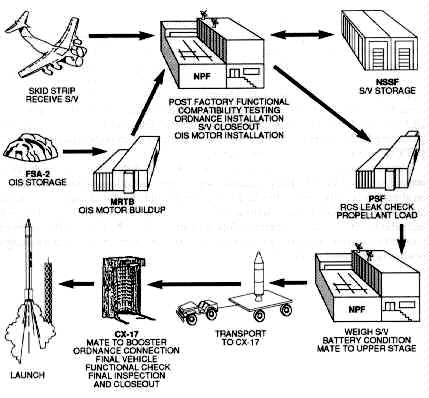
Source: 6555th Aerospace Test Group Briefing,Cape Canaveral AFS, May 1991.
Figure 9. Launch Base Processing Flow
The delivery of the satellite via air transport to Cape Canaveral Air Force Station initiates the flow. The satellite either awaits processing in the Navstar Satellite Storage Facility or goes directly to the Navstar Processing Facility (NPF). In the NPF, the satellite undergoes post-factory functional testing, compatibility testing, ordnance installation, and installation of the apogee kick motor or orbit insertion system that will place the satellite in its final operational orbit. From the NPF, the GPS satellite proceeds to the payload servicing facility for the hazardous operations of reaction control system (RCS) leak checks and loading the hydrazine (the RCS propellant).
Preparation of the booster takes place concurrently. The McDonnell Douglas Space Systems Company plant in Pueblo, Colorado, delivers the two stages of the Delta II. The stages are off-loaded and prepared for Delta mission checkout (DMCO). DMCO tests the entire two-stage booster to include an integrated functional test (preflight off the launch complex), electrical and hydraulic tests, and a composite check putting both stages through the entire flight program.41
Once the initial ground testing is complete, the second stage proceeds to the High Pressure Test Facility to test tank and system integrity. The facility uses high pressure nitrogen and helium to verify the system. Additionally, crews install the stage II range safety destruct harness. The second stage then continues to the launch complex to await the completion of processing of stage I.42
At the completion of DMCO, stage I goes to the Horizontal Processing Facility for the installation of the range safety destruct harness. Next, stage I continues to the launch complex and is erected. This usually takes one day and is followed by the installation of the solid rocket motors. The nine graphite epoxy motors are in sets of three with each set requiring one day for installation. Launch complex personnel pressure check the GEMs and install the ordnance. The interstage or "beer can" (a spacer between stage I and stage II) is installed, followed the next day by stage II installation. The simulated flight test is the culmination of the booster erection.43
Now, the launch is within days. The satellite, which has been waiting in the NPF, is transported to the launch complex and erected on the booster. Next is the final flight program verification, ordnance hookup, and installation of the payload fairing. At launch minus two days, the hypergolic fuels (nitrogen tetroxide and Aerozine-50) are loaded aboard stage II. On launch minus one day, all final checks in addition to the range safety destruct tests are complete. The terminal countdown runs approximately eight hours. Four hours prior to launch, the fuels (RP- l and liquid oxygen) are loaded aboard stage I.44
The main engine and six of the GEMs ignite at T-O. Early after launch, a roll program turns the booster to the appropriate flight azimuth. Before launch plus 60 seconds, the six GEMs burnout, the three remaining light, and the craft jettisons the depleted motors. The remaining GEMs burnout and separate at launch plus 122 seconds. Main engine cutoff (MECO) occurs at launch plus 264 seconds.45
Stage I separation occurs eight seconds after MECO, followed five seconds later by stage II ignition (fig. 10). The payload fairing is jettisoned at launch plus 298 seconds at an altitude where the free molecular heating rate is within tolerance. Stage II burns until launch plus 687 seconds followed by a 10-minute coast period. Stage II/stage III (satellite and orbit insertion system) separation follows a short 20-second burn. At the appropriate equatorial crossing, stage III ignites placing the satellite in its proper orbit awaiting the beginning of system checkout.46
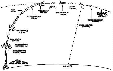
Source: 6555th Aerospace Test Group Briefing,Cape Canaveral AFS, May 1991.
Figure 10. Typical Delta II Mission Profile
1. AFM 1-1, Basic Aerospace Doctrine of the United States Air Force, vol. 1, March 1992, 7.
2. AFM 2-25, Space Operations, 29 March 1991, 18.
3. MSgt Warren Wright, "Quayle Announces New Launch Strategy," Space Trace, September 1991, 4.
4. TSgt Dennis Sanchez, "Eastern and Western Ranges" (Unpublished paper, AFSPACECOM/DOS, May 1992), 2.
5. Ibid.
6. Ibid., 3.
7. Ibid.
8. Ibid.
9. Ibid.
10. Defense Science Board, 1989 Summer Study on National Space Launch Strategy (Washington, D.C.: Office of the Under Secretary of Defense for Acquisition, March 1990), 13.
11. "Air Force Space Command Paper" (AFSPACECOM/DOSL, 16 September 1991), 13.
12. Ibid.
13. Ibid.
14. Ibid., 14.
15. Ibid., 10.
16. Ibid.
17. Ibid.
18. Ibid.
19. Ibid.
20. Ibid., 11.
21. Ibid. , 2.
22. Ibid., 3.
23. Ibid., 2.
24. Ibid., 3.
25. Ibid., 4.
26. Ibid.
27. Ibid.
28. Ibid., 6.
29. Ibid., 8.
30. Ibid.
31. Ibid.
32. Ibid., 15.
33. Ibid., 18.
34. Air Command and Staff College, Space Handbook (Maxwell AFB, Ala.: Air University Press, 1985), 13-1 through 13-14.
35. Lt Col David E. Lupton, On Space Warfare: A Space Power Doctrine (Maxwell Air Force Base, Ala.: Air University Press, June 1988), 23.
36. Sanchez, 3.
37. Ibid., 4.
38. Ibid.
39. Ibid., 5.
40. Maj Andrew Kraska, Director of Operations, 1st Space Launch Squadron, Cape Canaveral Air Force Station, telephone interview with the editor, May 1992.
41. Ibid.
42. Ibid.
43. Ibid.
44. Ibid
45. TSgt Dennis Sanchez, "Delta" (Unpublished paper, AFSPACECOM/DOS, May 1992), 4.
46. Ibid.
_____________________________________________________
Military strategy for space follows from the four distinct aerospace roles and missions: force support, force enhancement, force application, and aerospace control. Space strategy includes coordination of these missions in pursuit of national objectives and as directed by policy.1 Countries usually employ military forces consistently with basic doctrine. The 1992 version of AFM 1-1, Basic Aerospace Doctrine of the United States Air Force, implies that space forces are most effective when integrated with air forces.
The aerospace environment can be most fully exploited when considered as an indivisible whole.... Aerospace consists of the entire expanse above the earth's surface.... Its lower limit is the earth's surface ... and its upper limit reaches toward infinity.2
The function space forces are to perform drives their deployment. The USAF usually deploys communications satellites in geosynchronous orbits and weather satellites in Sun-synchronous orbits. Likewise, the Air Force usually deploys missile warning satellites in geostationary orbits and reconnaissance satellites in orbits optimizing resolution or collection time. Thus since two of the above space missions (force application and aerospace control) are constant regarding assets employed, it follows that we need only to discuss space missions: force support and force enhancement, in the context of space strategy as currently pursued by the US Air Force.
The space segment begins at an altitude where the principles of orbital mechanics replace the principles of aerodynamic lift. Space forces, like electronic warfare forces and mobility forces, support war fighters on land, on the sea, and in the air through all levels of conflict: low, mid, and high intensity. In addition, like air forces, space forces cannot be characterized as being solely strategic or tactical. Rather, space forces support multiple users and can simultaneously support strategic and tactical objectives. A good example of such support was the use of Defense Support Program satellites to provide theater/tactical warning during Operation Desert Storm while the satellites were also performing their strategic mission: attack assessment/warning of intercontinental ballistic missiles and submarine-launched ballistic missiles.
The first mission priority of Air Force space strategy, consistent with basic aerospace doctrine, is aerospace control. AFM l-1 states that
aerospace control normally should be the first priority of aerospace forces. Aerospace control permits aerospace and surface forces to operate more effectively and denies these advantages to the enemy. As the degree of control increases, all aerospace and surface efforts gain effectiveness. Conversely, any reduction in control threatens every mission, campaign, and type of force. Control is an enabling means rather than an end in itself....Absolute control of the environment is the ideal aim of aerospace control operations. Airmen must be particularly aware that aerospace control is generally a matter of degree. Absolute control of the air (air supremacy) or of space [space supremacy] is not possible as long as the enemy possesses any aerospace forces capable of effective interference.3
Controlling the space environment involves ensuring access to space, defense of friendly space forces, and offensive actions to deny the enemy's use of its space forces. Forces can achieve space supremacy by conducting offensive counterspace operations or defensive counterspace operations. The objective of offensive counterspace operations is to disrupt, disable, or destroy the enemy's access and ability to operate in space. Forces can attain these objectives through such hard-kill means as the employment of an antisatellite interceptor or ground-based laser and also by employing such nontraditional means as jamming, blinding, or spoofing. The objectives of defensive counterspace operations include active defense of friendly satellites and passive defense measures, such as frequency hopping, hardening, and maneuvering that reduce vulnerability and increase survivability.
US space supremacy was the key to the tactical deception operations carried out during Operation Desert Storm. Iraq's lack of space reconnaissance and surveillance capability allowed allied terrestrial forces to maneuver undetected and achieve surprise, thus saving lives and accelerating the termination of hostilities. The US cannot achieve the same level of success against an enemy possessing space forces without first achieving and maintaining space supremacy.
After achieving space supremacy, space forces can enhance ground forces. The force enhancement value space forces contribute to terrestrial operations in peacetime and during conflict is difficult to measure. However, Operation Desert Storm demonstrated that space forces are essential to overall US force posturing. Desert Storm was the first major combat operation where space was integrated into operations. Communication, navigation, weather, and space-based surveillance and warning satellites all supported theater forces and were directly responsible for the high degree of success achieved in combat. The lack of a communications infrastructure in Saudi Arabia forced ground commanders to use space-based communication assets (normally used for long-haul, intertheater communications) for intratheater communications. "Over 90 percent of all communication in theater was carried on satellite communications."4
Exaggerating the importance that the Global Positioning System (GPS) played in Desert Shield and Desert Storm is inconceivable. GPS, a space-based navigation system, provided ground forces, tactical air forces, and naval forces three-dimensional positional accuracy within 16 meters, velocity accuracy within 0.1 meters per second, and time accuracy to within 0.1 microsecond. In addition, GPS receivers are passive and do not emit a targetable signature like traditional navigation systems. Aircraft equipped with GPS receivers achieved great success finding targets and had greater bomb-on-target accuracies than platforms without GPS receivers. Ground forces were equipped with the GPS hand-held receiver. These receivers, small enough to fit m a trouser pocket, provided soldiers with an all-weather, day/night capability to find their way in terrain characterized by few landmarks. The hand-held receiver proved so versatile and indispensable that many were duct-tape mounted in vehicle panels and helicopter cockpits. At the conclusion of Desert Storm, in excess of ten thousand hand-held GPS receivers were in the theater. (See classified annex A for more information on GPS's role in Desert Storm.)
The Defense Meteorological Satellite Program (DMSP) also contributed significantly to combat operations during Desert Storm (see annex A). DMSP satellites and land- and sea-based transportable tactical ground terminals provided near-real-time infrared and high-resolution visual weather imagery of the area of operations. By providing current data on cloud cover and such atmospheric disturbances as dust storms, DMSP directly influenced target and weapon selection for interdiction sorties. In addition, the Army and Navy used DMSP data for planning aerial assaults and to warn ground and naval forces to "button up" during storms. The availability of DMSP prevented aborted sorties due to weather and saved lives and equipment.
While force support is concerned with what is to be done, how it is done, and where it needs to be done, force enhancement is concerned with the resources for multiplying combat effectiveness.5 In the book, Making Strategy, Col Dennis Drew and Dr Donald Snow identified the need for strategists to achieve balance between technology and mass when developing forces. Drew and Snow offered several reasons underlying the problems associated with achieving balance:
First, it is difficult, if not impossible, to calculate what degree of technological sophistication (quality) offsets what amount of mass (quantity).... Second, technology changes rapidly and the military advantages it offers are almost always temporary. Third, new technology is not battle tested before one is forced to rely on it. Fourth, possession of superior technology is no guarantee that the technology will be employed effectively or, in fact, that it will be employed at all.... Finally, clever operational strategy can offset an advantage whether that advantage is in quality or quantity.6
The Commander in Chief United States Space Command (USCINCSPACE) Gen Donald J. Kutyna, in testimony before the Senate Armed Services Committee on 23 April 1991, identified several high-priority space systems needed to implement the current military space strategy. First, to achieve space supremacy, General Kutyna identified the need to develop an antisatellite system. "The need for an antisatellite capability is simple: deny the enemy use of space systems integral to warfighting capability."7 The USCINCSPACE requirement to employ space forces for offensive counterspace activities is established in doctrine and supported by national space policy.
Second, existing tactical warning and attack assessment systems require improvements. As an increasing number of third world nations are acquiring tactical ballistic missile technology, the need for reliable and unambiguous warning is essential.8 In addition, the USAF needs to continue upgrading command center processing and display systems and survivable integrated communications and to replace the Cheyenne Mountain Air Force Base Communications System Segment.9
Third, spacelift infrastructure, including lift vehicles and supporting facilities, requires upgrading. As the cornerstone of US space force enhancement capability (note that spacelift is defined as a force enhancement mission in AFM 1-1), existing spacelift capability is degraded by
capacity constraints at the lift operations support elements: limited resiliency.for recovery from catastrophic failures; lack of flexibility caused by lift schedules driven primarily by hardware availability and long payload preparation timeliness; and today's high lift and integration costs.10
Fourth, the US needs the deployment of the Milstar communications system. As the major element of US war-fighting communications architecture, Milstar will provide anti-jam, interoperable communications and flexibility to adjust capacity in response to most operational requirements.11
This section provides an overview of satellite systems and launch vehicles to which General Kutyna referred. A few of the high-priority space systems needed in support of US military space strategy include space-based wide area surveillance (SBWAS) to provide warning information on global air and maritime threats; multispectral imagery to provide broad area change detection, terrain analysis, mapping support, and concealment information; Milstar to provide survivable communications for strategic and theater users; tactical satellites to augment existing space force structure quickly in crises or war; and the National Launch System to provide a robust capability to access space.12 These emerging space systems will enhance strategic and tactical warfare.
[Image 15K]
Space-Based Wide Area Surveillance Satellite
Space-based wide area surveillance is a proposed space-based, near-real-time, all-weather global surveillance, target acquisition, and tracking system for Air Force, Navy, and Army war fighters. General Kutyna told the Senate Armed Services Committee that an effective space-based wide area surveillance system has the potential to revolutionize tactics and to deny an adversary the element of surprise.13
SBWAS would employ one or both of two basic sensor phenomenologies--radar or infrared (IR). The radar concept would use an array antenna; the IR system would have either a staring or scanning sensor.
The phased array radar concept uses radio-frequency energy radiated through an array of transmit/receive (T/R) modules distributed across the face of a planar antenna.14 These modules allow phased arrays to instantaneously point the radar beam anywhere in its field of view. The drawbacks with a phased array system are the power requirements and the large number of electronic components required for a single antenna. Array integration and the number of T/R modules required pose significant challenges in cost and construction of a space-based system.
Infrared sensor concepts are promising because of their passive nature. The advantage of an IR sensor is its ability to provide better resolution through the use of small instantaneous fields of view. The primary disadvantage of IR is its susceptibility to degradation by weather.15
Regardless of the technology chosen for SBWAS, it has the potential to serve both strategic and tactical users. Strategic users of SBWAS data would be found at the level of data fusion centers, commanders in chief headquarters, carrier battle groups, and national decision makers. Tactical users of SBWAS data could be squadrons, wings, and battalions.
SBWAS data would include information on aircraft, ship, and ground target locations. The system would provide forward users longitude, latitude, azimuth, elevation, speed, direction, and classification type (i.e., aircraft, ship).16 The SBWAS system is intended to allow users to task the satellite constellation, assure timely distribution of detection and track data, and provide survivable surveillance support during conflict. Multiple-user communication paths and ground site transportability will provide enhanced survivability against ground attacks.
Track data would be disseminated in near real time to decision nodes and data fusion centers. The timeliness and quality of this data are critical to operational commanders because such data maximizes warning time and increases options in military response.
Multispectral imagery (MSI) is not a new technology; the civilian community uses it to study the Earth's landmass and oceans. MSI systems collect multiple, discrete bands of digital electro-optical imagery in the visible and reflected/emitted infrared regions of the spectrum.17 Current civil applications include estimate of nutrient content, identification of geologic structures, estimates of crop yields, location of transportation infrastructures, identification of pollution, and support of water management.
MSI data can provide terrain analysis, indicate surface conditions that can affect mobility, and provide tactically useful broad area surveillance as well as detailed image maps and charts useful to sustained ground campaigns. Combining MSI data with terrain elevation data allows aircrews to simulate flying a mission profile visually and choose optimum target approaches. Comparing MSI data of the same scene over time allows automated detection of changes in an area of interest. Combinations of visible and infrared imagery can make man-made efforts to conceal personnel and equipment stand out from the background.18 MSI data was used extensively during the Gulf conflict, but future MSI systems will need to be enhanced to meet the Department of Defense's tactical requirements. (Classified annex A provides more information on the role of MSI during Desert Storm.[Not here])
Primarily, DOD uses two space sensors for MSI data, Landsat and Satellite pour L'Observation de la Terre (SPOT). The original Landsat was a civil satellite system managed by NASA, then by the Department of Commerce. The current Landsat program is an integrated NASA/DOD program. SPOT is a French civil MSI program that sells imagery data. The US used SPOT imagery extensively for tactical planning, map updates, and terrain analysis during the Gulf crisis because SPOT features finer resolution than Landsat. However, neither of these systems meet timeliness, accuracy, resolution, wide-area coverage, or responsiveness criteria for current US tactical requirements.19
Requirements to make MSI a more productive system for future air, land, and sea campaigns are improved spectral and spatial resolution, stereo imaging, and wide-area coverage.20 If these requirements are met, MSI could play a major role in tactical decision making.
The military, strategic, and tactical relay satellite (Milstar) is the next generation military satellite communications system designed to serve the nation's strategic and tactical forces. The system will provide a worldwide, highly jam-resistant, survivable, and enduring satellite communications capability. Its design meets the minimum essential command and control communications requirements of the national command authorities and armed forces well into the next century. Use of extremely high frequency (EHF) and other advanced techniques will enable the system to achieve a high degree of survivability under both electronic warfare and physical attack. Unlike systems dependent on lower frequencies, EHF satellite communications recover quickly from the scintillation caused by a high-altitude nuclear detonation.21
The Milstar system will serve the strategic needs of US nuclear-capable forces and the priority needs of mobile tactical forces.22 Milstar has been specifically designed to overcome the shortfall characteristics of existing satellite communications systems. Concepts for survivability in a hostile space environment have shaped the design of this military communication system. Milstar will be the first major space-based communications effort using EHF technology (30-300 gigahertz) to overcome crowding and interference in other frequencies.23
The system will use a variety of new technologies, onboard signal processing, adaptive antennas, uplink nulling, steerable downlinks, and cross-links to provide satellite-to-satellite interconnectivity.24 Milstar will be capable of both EHF and ultra high frequency (UHF) transmissions to take advantage of existing air- and ground-based terminals. The use of higher frequencies offers a number of advantages--assurance of reliable communications in a nuclear environment, minimal susceptibility to enemy jamming and eavesdropping, and the ability to achieve smaller secure beams with modest-sized antennas.25 Milstar will be the first defense communication satellite system to use frequency hopping on the uplink to frustrate enemy eavesdropping and jamming. Additional protection against jammers will be obtained by using a phased-array antenna on the satellite that can minimize sensitivity in the direction of a jamming signal.26
The Milstar space segment will consist of a constellation of six satellites in a mixture of low- and high-inclination orbits. A low-inclination orbit would place the satellites in positions to cover the Atlantic, Pacific, and Indian Ocean areas and North and South America. Satellites in the high-inclination orbit would cover the polar regions, Europe, Africa, and western Asia.27 Satellite-to-satellite cross-link capability will assure global coverage. The cross-link network will route the appropriate communication traffic from terminals in view of one satellite to another terminal located at other parts of the world not covered by that satellite's field of view.28 The cross-link capability will provide near-real-time connectivity without extensive relay and circuit patching.
The Milstar space segment will serve priority users in all the services through a variety of ground terminals. Although each service manages a program to develop terminals suited to its unique operational needs, channelization and standardized signal formats will ensure system integrity and control.29 Two requirements for these terminals are mobility and compatibility. Rapid movement of communication terminals to the operational area, rapid setup, and quick circuit configuration are essential for timely support of the initial stages of deployment.30
The Ultra High Frequency Follow-on (UFO) Satellite Program will provide communications for airborne, ship, submarine, and ground forces. The UFO constellation will replace the current Fleet Satellite Communications System (FLTSATCOM) constellation and will consist of eight satellites and one on-orbit spare. The ground terminal segment will consist of equipment and resident personnel at existing satellite communication stations.31
Its UHF satellites will primarily serve tactical users. UFO will provide almost twice as many channels as FLTSATCOM and has about 10 percent more power per channel.32 The EHF package on satellites four through nine will have an Earth coverage beam and a steerable five-degree spot beam that enhances its tactical use. The EHF capability also allows the UFO network to connect to the strategic Milstar system.
First launch of the UFO is scheduled for the near future, with constellation completion dependent on replacement needs for the aging FLTSATCOM constellation. The Atlas II is the current launch vehicle of choice; however, space shuttle compatibility will exist. The UFO bus and payload will weigh 2,300 pounds. The solar array spans 60.5 feet and will produce 2,500 watts at the end of the planned 14-year lifetime.
Tactical satellites (tacsat) are an initiative to provide responsive and dedicated space-based, space combat support to the combatant commander. Concerns about availability of existing satellite to tactical commanders in an emergency and the ability to reconstitute satellite services in a conflict drive this concept. Tacsats would be a family of satellite systems designed to provide essential surveillance, warning, reconnaissance, communications, environment, and airspace control information.33
The tacsats are intended to provide an alternative to complex multi-mission space systems. Current plans include design features that would use standard interfaces to provide mission flexibility, responsive launch, simplified support, common training, and lower cost. The system would either launch on schedule or demand, using responsive vehicles or prepositioned assets in orbit.34 Built for simplicity, tacsats do not carry the redundant systems necessary to keep conventional satellites operational.35 They do not need these redundancies because less is expected of them in terms of mission and lifespan.
Tacsats would be smaller than conventional satellites by design (500 to 1,500 pounds in weight and only 38 inches in diameter). The smaller, simplified systems would cost less and could be readily produced. With few exceptions, the long development cycle time between requirement identification and launch date for advanced systems limits US ability to react quickly to fast-changing or newly emerging threat situations. Small, less complex space vehicles produced at lower costs would allow the US the ability to deploy quickly against specific threats.
The Air Force currently tailors constellations of large space vehicles for coverage of selected geographic areas based upon historical requirements. Thus, a change in coverage is at the expense of other geographic areas. Tacsats could fill geographic gaps for selected theaters of operation or other areas of interest. Using tacsats could not only provide dedicated battlefield support in wartime but also could help to reduce tasking conflicts for larger assets required for higher priority actions.
The current force structure emphasizes large multipurpose satellites which serve many users. Tacsats could give users who require dedicated support a space asset totally responsive to their needs. The use of these small satellites strategically planned in advance could also offer additional surge capability in time of war.
A benefit of tacsats is the relative ease with which boosters can place them in orbit. For example, Pegasus (an air-launched vehicle that can be strapped onto a B-52 or other aircraft and can boost approximately 400-700 pounds to low-Earth orbit36) could launch the lighter tactical satellite. This launch tool would give the theater or component commander the flexibility and responsiveness needed in a low-intensity conflict. The air-launched booster also offers more survivable access to space.
Tacsats could also augment the Defense Satellite Communications System and the future Milstar system. Desert Storm is a prime example of a situation in which tactical communications satellites could serve a significant role as a force multiplier.
The US Defense Advanced Research Projects Agency (DARPA) is the lead organization for tacsat experimentation. DARPA hopes to demonstrate a quick-reaction space capability for operational forces, learn about operational constraints and utility of small satellites, and establish baseline parameters for future small satellite systems.37 Tacsats would provide a capability to reconstitute and augment space systems during a period of high attrition and crisis situations. A tacsat system would give payload control to component commanders, allowing them to allocate system capability commensurate with the tactical situation.
In April 1991 the president's National Space Council (NSpC) directed a joint DOD/NASA program to develop and procure a family of launch vehicles and supporting infrastructure to meet civil, commercial, and national security needs. The national launch system (NLS) effort is aimed at providing NASA and DOD with a capability to deliver a wide range of payloads to low-Earth orbit at a low cost and with improved reliability.
Gen John L. Piotrowski, commander in chief United States Space Command, described the US military launch infrastructure as lacking characteristics key to other military forces: combat readiness, sustainability, and force structure.38 In recent years, a series of unfortunate events highlighted the fragile nature of the US launch infrastructure (the Challenger tragedy and the explosion at a solid motor propellant plant that destroyed more than half the nation's space and tactical missile propellant production capability).39 As a result of these problems, the NSpC outlined a national recovery plan. This plan rejects sole dependence on the shuttle for access to space and places emphasis on basic technology by calling for designing and building a new booster to meet the needs of US launch activities. This new booster will have to be cost-effective and efficient for peacetime launch, as well as survivable and responsive to the needs of combat forces.
The NLS is aimed at achieving a reliability of 98 percent or higher with a launch-on-schedule probability of at least 95 percent, vehicle availability of 90 percent or better, a 30 day or less launch response time, and a surge capability that will accommodate seven payloads within a five-day period.40 The NLS family of launch vehicles is based upon a set of common building blocks that can combine into different vehicles. The Air Force is currently reviewing three vehicle specifications (fig. 11). Designing common modules and using existing launch system elements will minimize NLS costs. The modules will be usable on different vehicles in the family without changing subsystems or redoing major qualification tests. This feature lowers production and operation costs. High-value avionics, control subsystems, and the main engines are integrated into a propulsion module that represents the large majority of the launch vehicle' s total cost. This module also allows recovery and reuse of the high-cost hardware.
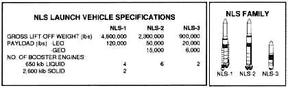
Source: Boeing Defense and Space Group,
"National Launch Systems" (Seattle, Wash. n.d.), 2.
Figure 11. National Launch System Vehicle Specifications
To achieve NLS cost, operational flexibility, responsiveness, and reliability goals, contractors are looking closely at both the technology and process involved in launch vehicles.41 Area contractors are reviewing on-site assembly of vehicles, launchpads (repairs and numbers), automation of vehicle/payload integration, adaptive guidance and control systems, and ground flow operations and analysis.42
On-site assembly of vehicles before they are positioned on a launchpad would reduce pad time, enable a multiprocessing capability, and facilitate the exploitation of built-in autonomous testing and processing.43 Months of final assembly and payload integration, all done on pad, inhibit rapid response to operational requirements.
Prelaunch preparation and post-launch refurbishment time requirements dictate a large number of pads. Adding flexibility to launch scheduling and allowing faster launch responsiveness in a crisis requires more launchpads and simplified launch structures. Pad redundancy would alleviate the risk of being denied access to space for certain payload/booster combinations and cover a launch catastrophe that could disable a pad for months.
Launch vehicle processing has historically employed large numbers of analysts for data monitoring, diagnostic interpretation, maintenance repair, mission planning, and real-time problem solving. The entire process of booster and payload testing, processing, and launch is lengthy, manpower intensive, and inflexible. An automated monitoring and testing system that can calibrate, process, store, and notify the user of which subsystem has failed and needs replacement could reduce the lengthy integration process time considerably.
Building in more software sophistication for launch guidance and control systems would enable a vehicle to adapt to changes it senses in flight without human intervention. In addition, design of a redundant, multi-string guidance and control package using lower cost components would reduce the expense associated with the current single string guidance package, which requires tightly screened electronic components.44
Low-cost ground operations require an automated system to document and manage ground operations, monitor health status, and perform fault isolation down to the lowest repairable unit. A set of automated test hardware embedded within the vehicle would be needed. The goal would be to develop systems that allow subsystem monitoring and diagnostics on a continuous basis and subsequent unit replacement with minimal time lost.
The long-term goal as seen by military leaders is to develop a launch system designed to function under an operational commander and responsive to operational requirements. Assured access to space has become an essential element of national security. Access to space through all levels of conflict is a must as it will contribute directly to US ability to deter war and to provide its forces with the support they need to resolve armed conflict on favorable terms.
[Image 18K]
National Aerospace Plane
The objective of the national aerospace plane (NASP), or X-30 program, is to develop and demonstrate the technology for hypersonic-to-orbital flight vehicles that have technical, cost, and operational advantages over existing military and commercial aircraft and space launch systems.45 Development of hypersonic-to-orbital velocity test equipment, new materials and fabrication methods, and advanced combustion technology is a major technological challenge.46
Five prime contractors, represented by a national program office and the government-led USAF/NASA/Navy joint program offices at Wright-Patterson AFB, Ohio, are leading the NASP effort. Designers plan for the X-30 to demonstrate sustained hypersonic cruise at velocities of Mach 5 to 14 at altitudes between 80,000 and 150,000 feet.47 It also is to demonstrate single stage to orbit speeds of Mach 25. Designers expect propulsion for the vehicle to be provided by three to five supersonic combustion ramjet (scramjet) engines and by a single 50,000- to 70,000-pound thrust rocket integrated into the airframe.48 Early reports depict four different types of engines working together to get the plane rolling and up to hypersonic-orbital velocity. The craft will rely on turbojets, which use a spinning turbine to draw air into a combustion chamber and compress it, to reach Mach 2. At that speed, air is rushing into the engine so fast that it compresses itself, and the turbine's blades become a hindrance. The turbojets will shut down, and ramjets kick in. Ramjets work like turbojets except they have no blades. The front of the ramjet simply gulps in air, and the high speed of the plane helps squeeze a maximum amount of air into the combustion chamber, compensating for the lower oxygen levels found at higher altitudes. The ramjets will operate until the plane reaches between Mach 6 and 8 when scramjets take over. The scramjets will carry the plane to Mach 20 and lift it to the edge of space. At that nearly airless altitude, hydrogen-fueled rocket engines will push the plane to Mach 25 and send it into orbit.49
More innovative than the space plane's engine scheme will be its skin. With the space plane, temperatures will rise not only when the plane is coming down but also when it is going up. The heating is due to the plane's speed and the trajectory it will follow during its climb. The NASP program has been a catalyst for significant advances in metal and metal-matrix technologies. The objective of the materials work by the NASP contractors is to reduce the X-30's weight as much as possible to cut the amount of fuel and thrust required by the engines in addition to solving the heat management problems.
In October 1990 the NASP program selected the lifting body design because it provides propulsion advantages over a winged aircraft. The directionally stable lifting body incorporates short wings, dual stabilizers, and a two-man, dorsal crew compartment.50 The plane will probably be 150 to 200 feet long and have a wingspan of about 50 feet.51 The formal teaming of the contractors and selection of a single design will allow program resources to be concentrated and technical problems and solutions to be more sharply defined.
The focus of the program is to get to orbit using a single-stage vehicle and to stretch the limits of air-breathing propulsion technology. NASP is a stimulus to new technology and can provide space launch flexibility and cheaper access to space. The fundamental barrier to reducing the costs of space launch with rockets is technical--the need to carry both fuel and oxygen. Development of NASP can lighten this inescapable weight burden and associated cost per pound.
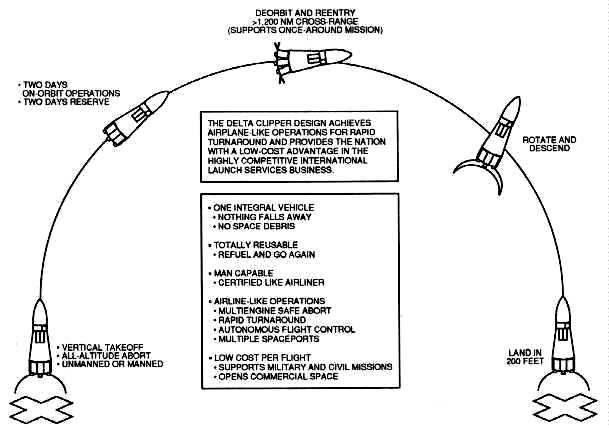
Source: McDonnell Douglas Space Systems Company,
"Single Stage Rocket Technology" (Huntington Beach, Calif., n.d.), 1-2.
Figure 12. Simple Stage to Orbit
The single stage to orbit (SSTO) program basically has the same objectives as the NASP program--to develop a cheap and reliable spacecraft that will have widespread military, commercial, and scientific applications. SSTO differs from NASP in that it is a vertical takeoff and landing orbiter. The benefits of SSTO also mirror that of NASP: recoverable, reusable, low cost, and flexible as to its launch capability.
Many technologies critical to the development of this single stage vehicle (known as the Delta Clipper) have been derived from the related national aerospace plane and the national launch system programs. Research and development of lightweight composite aeroshell structures, fabrication of modular reusable engines, and manufacturing knowledge for graphite-epoxy composite cryogenic fuel tanks are available for use on the Delta Clipper project.52
Designed to meet the requirements of a broad set of commercial and military missions, the Delta Clipper offers a path to vastly improved space transportation where rocket performance combines with routine airline safety and reliability. The ship has the capability for vertical takeoff and landing, for which operational feasibility has already been demonstrated both on Earth and the Moon.53 It would launch like an everyday expendable launch vehicle and land like a lunar module. Navigation and guidance would be accomplished via global positioning satellites.
The vehicle would be able to operate independently of complex launch ranges and mission controls, as it can launch on demand from any base and in any direction. Vehicle and ground servicing techniques are derived from those used for commercial aircraft. Automated ground flight operations would reduce the number of support personnel needed and associated costs.
The planned versatility of the spacecraft is impressive. The spacecraft could operate with or without a crew. It will launch with an acceleration of 1.3g, far less than the 3g force astronauts experience on the shuttle.54 The Delta Clipper could remain in orbit for missions lasting seven to 14 days and with on-orbit fueling could serve as a transfer vehicle to geostationary orbit. The craft reenters the atmosphere nose first, then rotates for a vertical landing (fig. 12). In powered descent, half the engines operate at 20 percent power, while the others remain in reserve for contingencies.55
Congress has approved funding for a one-third scale model flight demonstration scheduled in 1993. A full-scale Delta Clipper is scheduled to make a first orbital flight by the late summer of 1996. The full-scale spacecraft will be 127 feet high, have a gross weight of just over one million pounds, and a payload capacity of 10,000 pounds.56
The Strategic Defense Initiative Organization is acquiring and managing the global protection against limited strikes (GPALS) system. GPALS consists of multilayered ground and space-based sensors and weapons that will provide the capabilities for global surveillance and destruction of ballistic missiles.
GPALS is comprised of three segments: theater missile defense, national missile defense, and global missile defense. These segments and the GPALS architecture are discussed in chapter 3. In operation, GPALS will give the US and allied nations high-confidence protection against limited ballistic missile attacks, including accidental or unauthorized launches from any source.
The role of space in future conflicts will be limited only by failures to develop new technologies and enhancements to current space systems and to provide access to war fighters. Space and launch systems of tomorrow must focus on requirements to provide improved tactical warning and attack assessment. Upgrades to the ground- and space-based surveillance assets, improved launch capacity, support needs, flexibility, and responsiveness of space systems are a necessity to ensure continued support of US air, land, sea, and space forces.
1. Col Dennis M. Drew and Dr Donald M. Snow, Making Strategy: An Introduction to National Security Processes and Problems (Maxwell AFB, Ala.: Air University Press, 1988), 83.
2. AFM I-1, Basic Aerospace Doctrine of the United States Air Force, vol. I, March 1992, 5.
3. Ibid., 10 11.
4. Gen Donald J. Kutyna, "Testimony Before Senate Armed Services Committee," manuscript briefing, 23 April 1991, 19.
5. Drew and Snow, 85.
6. Ibid., 86-87.
7. Kutyna, 3 1.
8. Ibid., 29.
9. Ibid., 30.
10. Ibid., 32.
11. Ibid., 34.
12. Ibid., 35-37.
13. Ibid., 35.
14. Capt Paul J. Helt, "Space Based Wide Area Surveillance System" (Unpublished paper, AFSPACECOM/XRFT, undated), 3.
15. William L. Wolfe and George J. Zissis, eds., The Infrared Handbook (Ann Arbor, Mich.: Environmental Research Institute of Michigan, 1985), 22.46.
16. Helt, 3.
17. Capt David Dingle, "Multispectral Imagery Capability" (Unpublished paper, AFSPACECOM/XRFT, 17 May 1991),1.
18. Ibid.
19. Ibid.
20. Ibid.
21. Maj Theodore W. Burgner, "Space Handbook" (Paper presented as input for revision of Air University Space Handbook, 2d Space Wing/DOT, Falcon AFB, Colo., August 1991),12.
22. C. Richard Whelan, Guide to Military Space Programs (Arlington, Va.: Pasha Publications Inc., 1984), 58.
23. Dr Kostas Liopiros and Dr Edward Lam, "Extremely High Frequency Satellites Offer Flexibility," Signal 44, no. 11 (July 1990): 77.
24. James W. Rawles, "Milstar Fights for Survival," Defense Electronics 22, no. 3 (March 1990): 51.
25. Philip J. Klass, "First Milstar Satellite to Undergo Final Integration Tests in 1990," Aviation Week & Space Technology, 3 April 1989, 61.
26. Ibid.
27. Whelan, 61.
28. Liopiros and Lam, 79.
29. Whelan, 64.
30. Liopiros and Lam, 78.
31. Burgner, 51.
32. Michael A. Dornheim, "Navy Likely to Add New Capability to UHF Follow-on Communications Satellites," Aviation Week & Space Technology, 4 June 1990, 69.
33. Capt Mark Tyson, "Tactical Satellites Initiative" (Unpublished paper, AFSPACECOM/XRFT, 20 August 1991), 1.
34. Ibid.
35. Holly Porteous, "Satellites Made Simple--Lightsats," Jane's Defence Weekly 15, no. 22 (1 June 1991): 926.
36. Capt Mark J. Deves, "Light Satellites Capture Military Planner Interest," Signal 45, no. 10 (June 1991): 54.
37. Barry Miller, "Lightsats to Boost Survivable Access to Space," Armed Forces Journal International 127, no. 11 (June 1990): 54.
38. Gen John L. Piotrowski, "Military Space Launch: The Path to a More Responsive System (Part 1)," Aerospace & Defense Science 9, no. 7 (July 1990): 43.
39. Ibid.
40. William B. Scott, "ALS Cost, Efficiency to Depend Heavily on Process Improvements," Aviation Week & Space Technology, 23 October 1989, 41.
41. Ibid.
42. Ibid., 43.
43. Piotrowski, 40.
44. Scott, 43.
45. Edward H. Kolcum, "Contractors Pursue NASP Technology Despite Possible Funding Cutbacks," Aviation Week & Space Technology, 22 May 1989, 96.
46. Ibid.
47. Ibid., 97.
48. Stanley W. Kandebo, "Lifting Body Design is Key to Single-Stage-to-Orbit," Aviation Week & Space Technology, 29 October 1990, 36.
49. Jeffrey Kluger, "Space Plane," Discover, November 1989, 82.
50. Kandebo, 36.
51. Ibid., 23.
52. "Single Stage To Orbit Gains New Momentum, Adherents," Signal, June 1991, 37.
53. Ibid., 38.
54. A. Royce Dalby, "The Delta Clipper," Ad Astra, October 1991, 25.
55. Ibid.
56. Edward H. Kolcum, "Delta Clipper Partners Set Goal for Single-Stage-to-Orbit Vehicle," Aviation Week & Space Technology, 3 February 1992, 56.
_____________________________________________________
ABM             antiballistic missile
ADCOM           Aerospace Defense Command
ADTV            Agena docking target vehicle
AEC             Atomic Energy Commission
AFB             Air Force base
AFEWC           Air Force Electronic Warfare Center
AFGWC           Air Force Global Weather Central
AFIC            Air Force Intelligence Command
AFS             Air Force station
AFSATCOM        Air Force Satellite Communications System
AFSCN           Air Force Satellite Control Network
AFSPACECOM      Air Force Space Command
AIS             American Interplanetary Society
AMOS            Air Force Maui Optical Station
ANMM            AFSPACECOM National Mission Model
AO              area of operations
ARDC            Air Research and Development Command
ARPA            Advanced Research Projects Agency
ARS             American Rocket Society
ARTS            automated remote tracking station
ASAT            antisatellite
ASSC            Alternate Space Surveillance Center
ATBM            antitactical ballistic missile
AWACS           Airborne Warning and Control System

BDA             battle damage assessment
BE              Brilliant Eyes
BM              battle management
BMD             ballistic missile defense
BMEWS           Ballistic Missile Early Warning System
BoMi            bomber missile
BP              Brilliant Pebbles

C3              command, control, and communications
CACS            command and control squadron
CCAFS           Cape Canaveral Air Force Station
CCC             communications control complex
CCS             command and control system
CENTCOM         Central Command
CGS             CONUS ground station
CIA             Central Intelligence Agency
CIC             Combat Intelligence Center
CMAFB           Cheyenne Mountain Air Force Base
CONUS           continental United States
CROSS           Combined RF/Optical Surveillance System
CS              Constant Source
CSP             contact support plan
CSTC            Consolidated Space Test Center
CTS             Colorado Tracking Station

DARPA           Defense Advanced Research Projects Agency
DDC             Data Distribution Center
DE              directed energy
DEW             directed energy weapons
DLT             data link terminal
DMA             Defense Mapping Agency
DMCO            Delta mission checkout
DMSP            Defense Meteorological Satellite Program
DOD             Department of Defense
DSCS            Defense Satellite Communications System
DSIS            Defense Communications System/Satellite Control Facility
                Interface System
DSMM            DOD Spacelift Mission Model
DSP             Defense Support Program
DSTS            deep-space tracking system

E2I             endo-exoatmospheric interceptors
EDC             Earth Resources Observation System Data Center
EGS             European ground station
EHF             extremely high frequency
ER              Eastern Range
EROS            Earth Resources Observation System
EVA             extra-vehicular activity
EW              electronic warfare

FEWS            Follow-on Early Warning System
FLTSATCOM       Fleet Satellite Communications System
FNOC            Navy Fleet Numerical Oceanography Center
FOBS            fractional orbit bombardment system
FSOC            Fairchild Satellite Operations Center

GAO             General Accounting Office
GBI             ground-based interceptors
GBRT            ground-based radar trackers
GC              ground controller
GEM             graphite epoxy motors
GEODSS          ground-based electro-optical deep space surveillance
GHz             gigahertz
GPALS           global protection against limited strikes
GPS             Global Positioning System
GSTS            ground-based surveillance and tracking system
GT              Gemini Titan
GTO             geostationary transfer orbit

HEDI            high-endoatmospheric defense interceptor
HPF             horizontal processing facility
HPTF            high pressure test facility

IA              interim agreement
ICBM            intercontinental ballistic missile
IDSCS           Initial Defense Satellite Communications System
IGY             International Geophysical Year
IOC             initial operational capability
IR              infrared
IRBM            intermediate range ballistic missile
IRO             interrange operations

JCS             Joint Chiefs of Staff
J-STARS         Joint Surveillance Target Attack Radar System

KE              kinetic energy
KMR             Kwajalein Missile Range
KSC             Kennedy Space Center

LASS            low-altitude surveillance system
LCO             lead communications operator
LEASAT          Leased Satellite Communications System
LSO             Launch Services Office
LWIR            long wavelength infrared

MA              Mercury Atlas
MCS             master control station
MCT             mission control team
MECO            main engine cutoff
MHV             miniature homing vehicle
MILSATCOM       military satellite communications
Milstar         military, strategic, and tactical relay satellite
MIRV            multiple independently targetable reentry vehicle
MLV             medium launch vehicle
MOL             Manned Orbital Laboratory
MOTIF           Maui Optical Tracking and Identification Facility
MPF             multi-purpose facility
MPSOC           Multi-Purpose Satellite Operations Center
MR              Mercury Redstone
MSI             multispectral imagery
MSR             missile site radar
MSS             multispectral scanner
MWS             missile warning squadron

NACA            National Advisory Committee on Aeronautics
NASA            National Aeronautics and Space Administration
NASP            national aerospace plane
NATO            North Atlantic Treaty Organization
NAVSPASUR       Naval Space Surveillance
NAVSTAR         Navigation Satellite Timing and Ranging
NCA             National Command Authorities
NCS             network control system
NFL             new foreign launch
NICSCOA         NATO Integrated Communications System Operating Agency
NLS             national launch system
NMCC            National Military Command Center
NORAD           North American Aerospace Defense Command
NPF             Navstar Processing Facility
NRL             Naval Research Laboratory
NRT             near real time
NSC             National Security Council
NSD             National Security Directive
NSDD            National Security Decision Directive
NSDM            National Security Decision Memorandum
NSpC            National Space Council
NSSF            Navstar Satellite Storage Facility
NSPD            national space policy directives
NUDET           nuclear detonation

OC              operations center
OGS             overseas ground station
OIS             orbit insertion system
OLS             operational linescan system
OPS             operations
OSMC            Operational Software Maintenance Complex

P&A             plans and analysis
PAR             perimeter acquisition radar
PARCS           Perimeter Acquisition Radar Attack Characterization System
PASS            Passive Surveillance System
PBV             post-boost vehicle
PD              presidential directive
PMALS           prototype miniature air launched system
PSF             payload servicing facility

RADINT          radar intelligence
RC              resource controller
RCC             resource control complex
RCS             radar cross section
                reaction control system
RC/TA           remote communications/telemetry areas
R&D             research and development
RF              radio frequency
RS              resource scheduling
RTS             remote tracking station
RV              reentry vehicle

SA              selective availability
SAC             Strategic Air Command
SAINT           Air Force satellite interceptor
SALT            Strategic Arms Limitation Talks
SAM             surface-to-air missile
SATCOM          satellite communications
SBWAS           space-based wide area surveillance
SCOUT           Solid Controlled Orbital Utility Test
SCS             satellite control squadron
SDIO            Strategic Defense Initiative Organization
SDTL            Software Development Test Laboratories
SHAPE           Supreme Headquarters Allied Powers Europe
SLAG            Space Launch Advisory Group
SLBM            submarine-launched ballistic missile
SOC             satellite operations center
SOG             satellite operations group
SOI             space object identification
SPADOC          Space Defense Operations Center
SRB             solid rocket booster
SRM             solid rocket motor
SRMU            solid rocket motor upgrade
SSC             Space Surveillance Center
SSN             space surveillance network
SSTO            single stage to orbit
SSTS            space-based surveillance and tracking system
STG             Space Task Group
STS             space transportation system
SV              space vehicles

TACELINT        tactical electronic intelligence
tacsat          tactical satellite
TAF             tactical air force
TBM             tactical ballistic missile
TENCAP          Tactical Exploitation of National Capabilities Program
TEOB            tactical elint order of battle
TERS            Tactical Event Reporting System
TIP             tracking impact prediction
TM              thematic mapper
T/R             transmit/receive
TRAP            tactical and related applications
TRW             Thompson-Ramo-Wooldridge
TT&C            telemetry, tracking, and commanding
TW/AA           tactical warning/attack assessment

UFO             ultra high frequency follow-on
UHF             ultra high frequency
UN              United Nations
USCENTCOM       United States Central Command
USCINCSPACE     United States commander in chief Space Command
USSPACECOM      United States Space Command

VAFB            Vandenberg Air Force Base
VTS             Vandenberg Tracking Station

WCP             wing command post
WR              Western Range
WSMR            White Sands Missile Test Range
[End Space Handbook, Volume I]
Thanks to the author and AU Press.
Transcription and hypertext by JYA/Urban Deadline.